transboundary diagnostic analysis of the
binational basin of the bermejo river
Binational Commission for the Development of the Upper
transboundary diagnostic analysis of the binational basin of the bermejo river
Bermejo River and Grande de Tarija River Basins
www.cbbermejo.org.ar
Global Environment Facility
www.gefweb.org
United Nations Environment Program
www.unep.org
Organization of the American States
www.oas.org
Binational Commission for the Development of the Upper
Bermejo and Grande de Tarija River Basins
www.cbbermejo.org.ar
Global Environment Facility
www.gefweb.org
United Nations Environment Programme
www.unep.org
Organization of American States
www.oas.org
TRANSBOUNDARY
DIAGNOSTIC ANALYSIS
FOR THE BINATIONAL BASIN
OF THE BERMEJO RIVER
FINAL VERSION
Republic of Argentina
Republic of Bolivia
MAY 2000
TABLE OF CONTENTS
1. INTRODUCTION
1.1. The Strategic Action Program for the Bermejo River Basin
1.2. Location and Political Structure
1.3. Contents of the Transboundary Diagnostic Analysis
1.3.1. Background
1.3.2. Structure of the Transboundary Diagnostic Analysis
1.4. The Environmental Profile of the Basin
1.4.1. Natural environment
1.4.2. Legal and institutional framework
1.4.3. Socioeconomic aspects
1.4.4. Environmental forecast of the Basin
2. ENVIRONMENTAL PROBLEMS AND TRANSBOUNDARY MANIFESTATIONS
2.1. Introduction
2.2. Characterization of the major environmental problems
2.2.1. Soil degradation. Intense erosion and desertification processes
2.2.2. Water scarcity and availability restrictions
2.2.3. Degradation of water quality
2.2.4. Destruction of habitats, loss of biodiversity and deterioration of
biotic resources
2.2.5. Conflicts from flooding and other natural disasters
2.2.6. Deteriorating human living conditions and loss of cultural
resources
2.3. Identification of Common Basic Causes
2.3.1. Inadequate political, legal and institutional framework
2.3.2. Poor planning and coordination between and within jurisdictions
2.3.3. Insufficient knowledge, commitment and participation by the
community and failure to encourage such participation
2.3.4. Inadequate financing and support mechanisms
2.3.5. Inadequate access to and application of sustainable technologies
2.4. Causal Chain
2.5. Synthesis of Environmental Problems
3. ENVIRONMENTAL PROBLEMS AND ITS RELATIONSHIP WITH STRATEGIC
ACTIONS
3.1. Introduction
3.2. Strategic Action Framework
3.3. Priority Environmental Problems, their Causes and Strategic Actions
3.4. Priority Actions, Scope of application and Basic Diagnostic Aspects
4. BIBLIOGRAPHIC REFERENCES PRODUCED BY THE SAP
5. LIST OF ACRONYMS
6. CARTOGRAPHIC FIGURES
Aspects of the natural environment
Figure Nş 1
Location of the Bermejo River Basin
Figure Nş 2
The Bermejo River Basin
Figure Nş 3
Base Map
Figure Nş 4
Hydrology
Figure Nş 5
Climate: Rainfall
Figure Nş 6
Soil Use Capacity
Figure Nş 7
Vegetation
Figure Nş 8
Nature Protected Areas
Figure Nş 9
Eco-regions, Sub-regions, and Major Units
Socioeconomic aspects
Figure Nş 10
Political division
Figure Nş 11
Total population density
Figure Nş 12
Total population with basic needs unmet
Figure Nş 13
Soil use
Figure Nş 14
Soil use with agroindustrial crops
Figure Nş 15
Generation of industrial jobs
Indicators of environmental problems at the level of the Major Units
Figure Nş 16
Deforestation
Figure Nş 17
Erosion
Figure Nş 18
Desertification
Figure Nş 19
Flooding and potential flooding
Figure Nş 20
Risk of loss of biodiversity
Figure Nş 21
Indicators of environmental zoning
Figure Nş 22
Indicators of environmental zoning
Indicators of environmental problems at the sub-regional level
Figure Nş 23
Illiterate population
Figure Nş 24
Subdivision of the land
7. ANNEXES
Annex I
SAP Work Elements
Annex II
Basic Environmental Information
Annex III Definition of Ecological Regions
Annex IV Environmental Zoning
Annex V
Quantification, location and assessment of Environmental Problems
2
INDEX OF TABLES
Table Nş 1
Territorial distribution of the Basin
Table N° 2
Population characteristics of the Basin. Estimated data
Table Nş 3
Total areas affected by soil degradation, erosion and desertification
Table Nş 4
Deforestation and threats to biodiversity
Table Nş 5
Nature Protected Areas
Table Nş 6
Size of Protected Areas, by Eco-region
Table N° 7
Number of endangered flora and fauna species by Eco-region
Table Nş 8
Conflicts from flooding and waterlogging, by Large Ecological Units
Table Nş 9
Geographic gross product of the Basin
Table Nş 10
Environmental Problems, symptoms, effects and transboundary
manifestations
Table Nş 11
Strategic Actions
Table Nş 12
Environmental Problems, Causes and Strategic Actions
Table Nş 13
Strategic Actions as they relate to fundamental concepts of the
Diagnosis
INDEX OF SKETCHES
Sketch N° 1 Methodological sketch: Identification of Causal Relationships
Sketch N° 2 Causal Relationship Chain for the Main Environmental Problems
3
1. INTRODUCTION
This Transboundary Diagnostic Analisys (TDA) is one of the principal results of the
Project to formulate a Strategic Action Program (SAP) for the Bermejo River Basin
and is intended to provide technical support and a strategic framework for that
Program.
1.1. The Strategic Action Program for the River Bermejo Basin
The Strategic Action for the Bermejo River Basin (SAP) was prepared as a joint effort
by the governments of Argentina and Bolivia, through the Binational Commission for
the Development of the Upper Bermejo River Basin and Grande de Tarija River Basins.
The work was carried out in both countries, beginning in August 1997, and was
completed in December 1999. The executing agency was the Organization of American
States (OAS), which is responsible for administering the funds supplied for the project
the Global Environment Facility (GEF) through the United Nations Environment
Program (UNEP).
The principal objective of the Strategic Action Program is to promote sustainable
development in the binational and inter-jurisdictional basin of the Bermejo River by: (i)
incorporating environmental concerns into the development policies, plans and
programs of the various jurisdictions, (ii) fostering an integrated management vision of
the basin and its natural resources, (iii) promoting the establishment of mechanisms for
regional articulation and coordination and public participation in consultation, through
(iv) implementation of programs, projects and actions that will (v) prevent or overcome
unsustainable use and environmental degradation of natural resources and (vi)
stimulate the adoption of sustainable practices for managing natural resources.
1.2. Location and Political Structure
The Bermejo River basin is located in the extreme southern portion of Bolivia, in the
department of Tarija, and in northern Argentina, where it embraces portions of the
provinces of Chaco, Formosa, Jujuy and Salta. Figure Nş 1 shows the location of the
basin with respect to the South American continent, and Figure Nş 2 shows its political
and administrative boundaries within the regional context.
The political and administrative structure in the two countries is different (Figure Nş
10). In Argentina, the system is that of a federal government, based on a confederation
of states known as Provinces. Bolivia has a centralized government system, under
which the country is divided into Departments.
The binational nature of the Bermejo River, and the federal system of organization
prevailing in Argentina, gives the basin an inter-jurisdictional character that makes the
institutional setting of this project particularly complex. The following levels of
government are involved:
Binational:
Binational Commission for Development of the Upper
Bermejo River and the Rio Grande the Tarija Basin
1
Regional:
Argentina:
Regional Commission for the Bermejo River1 (COREBE)1
Bolivia:
National Commission for the Pilcomayo and Bermejo
River (CONAPIBE)
Provincial level: Argentina:
Provinces of Chaco, Formosa, Jujuy and Salta
Departmental level: Bolivia: Department of Tarija
1.3. Contents of the Transboundary Diagnostic Analysis
1.3.1. Background
Preparation of a Transboundary Diagnosis was a specific objective of one of the three
major areas of work undertaken by the project to formulate the SAP, namely: (i)
transboundary diagnosis, (ii) public participation and pilot demonstrations projects, and
(iii) formulation of the Strategic Action Program. The work involved analysis of a local
and regional character, as well as sector studies, that served to update and supplement
the regional and transboundary diagnosis by addressing issues such as the generation
and transportation of sediments, water quality, environmental zoning, integrated water
resource management, the legal and institutional framework, and transboundary
migration, among others. As well, pilot demonstration projects were carried out in
different representative zones of the basin. On the basis of the studies and
consultations undertaken during the project, it was possible to incorporate additional
valuable information on various aspects (natural and social) of the basin, its major
regional and transboundary problems, their basic causes and the strategic areas for
action that make up this diagnosis and provide a foundation and context for the
Strategic Action Program.
In addition to generating information for the project itself, with the participation of more
than 30 institutions and more than 260 experts in different disciplines (Annex I lists the
completed SAP work elements. Chapter 4 of this report presents the documents and
reports produced by those Elements between 1997 and 1999) who helped in preparing
this environmental diagnosis, we drew upon available information from primary and
secondary sources and input from experts, government agencies and NGOs, including
the following, among others:
· A great number of sector and environmental studies, at the local or regional scale
throughout the Bermejo River basin, that have been produced over the last few
decades. Several bibliographic compilations, such as those produced in Argentina
in 1986 by the Federal Investment Council (CFI), with nearly 800 entries, and the
one produced by COREBE in 1991, are typical of the many efforts that have been
made at both the central and provincial level in this regard2. Similarly, the National
Commission for the Pilcomayo and Bermejo Rivers (CONAPIBE) and other
1 Federal agency created in Argentina by representatives of the national government, the riparian
provinces of Chaco, Formosa, Jujuy and Salta and the provinces of Santa Fe and Santiago del Estero.
2 Much background material was also compiled by central institutions such as the National Agricultural
Technology Institute, local universities and provincial agencies.
2
institutions in Bolivia have made an important effort to develop a greater
understanding of the basin.
· Among the studies, we wish to note in particular those that were produced with the
support of the Organization of American States on the Bermejo River (OAS 1971-
1973. Water Resources Study of BermejoRiver Basin) and La Plata River Basin
(OAS 1981. Río de la Plata: Basin; Study for the Planning and Development.
Bermejo River Basin. I Upper Basin; II Lower Basin), and those sponsored in
Argentina by COREBE, particularly those relating to the various stages and
components of the Study on the Development of Water Resources conducted
between 1993 and 1998, the latter within the context of the Binational Commission
for the Upper Bermejo River and the Rio Grande the Tarija Basin.
· Reports produced during the previous stage of preparation of the SAP project
(PDF Block B)3 condensing the most representative information from the various
background sources.
· The results and conclusions of the Workshops that were conducted in both
countries as part of the public participation program. In Argentina, there were three
workshops in the cities of Salta, Formosa and Jujuy (see bibliographic references
39, 40 and 41, in Chapter 4) and in Bolivia six seminars and workshops were held
in the city of Tarija, involving a total of more than 1000 participants.
Constant contact has been maintained with various stakeholders (governmental and
nongovernmental) in the basin. Through their various activities under the SAP, they
have contributed their knowledge and opinions on many different issues to this
diagnosis. Of special importance were the contributions to meetings of the
Governmental Working Group (GTG SAP)4 in Argentina.
1.3.2. Structure of the Transboundary Diagnostic Analysis
On the basis of existing knowledge about the basin (see in Chapter 4 the bibliography
generated by the various activities and work elements of the SAP between 1997 and
1999) a summary Environmental Profile has been prepared (an expanded version is
found in Annex II), covering the most significant aspects of the basin's natural
environment, its socioeconomic aspects and its legal and institutional setting. The
environmental characteristics are frequently geo-referenced in terms of a series of
Ecological Regions5 (Annexes II and III). This categorization identifies and delimits
homogeneous areas that are hierarchically related, as a tool for analyzing the principal
ecological processes and their associated environmental restrictions and conflicts. The
information provided by the various Work Elements (Annex I) makes it possible to
dimension and locate geographically the problems and symptoms that were detected
during the regional workshops in both countries.
3 PDF-Project Preparation and Development Facility, Block B
4 The Working Group in Argentina consisted of representatives of the provinces of Chaco, Formosa,
Jujuy and Salta, the Argentine delegation to the Binational Commission for the Upper Basin and
COREBE
5 The relationship between these Eco-regions and those identified in Dinerstein et al (1995) is explained in
Annex II.
3
The Transboundary Diagnostic Analysis (TDA) presents a characterization of the
environmental problems and their transboundary manifestations under the following
headings:
· Soil degradation. Intense erosion and desertification processes
· Water scarcity and availability restrictions.
· Degradation of water quality.
· Destruction of habitat, loss of biodiversity and deterioration of biotic resources.
· Conflicts from flooding and other natural disasters.
· Deteriorating human living conditions and loss of cultural resources
These major environmental problems show up in the water, the natural resources, the
land and the societies within the basin, as a consequence of various processes and
human activities, together with pre-existing or human-induced environmental
limitations. In other words, they reflect the approach to development and
environmental management followed in both the distant and recent past. These
problems now make themselves felt as constraints on sustainable development.
Each environmental problem has been analyzed on the basis of the following factors:
· Symptoms and Effects.
· Transboundary
Manifestations
· Direct
Causes.
· Common and Specific Basic Causes.
The most significant symptoms and effects are assessed by means of ecological and
socioeconomic indicators, either qualitative or quantitative, for dimensioning and
assessing the severity of the environmental problems identified in the Bermejo River
basin
Focusing on the watershed as the object of study and action, reveals more clearly the
trans-border manifestations of existing problems, acting through the dynamic
processes and components of the natural and social systems. The Bermejo river
crosses the border between Bolivia and Argentina, passes through 4 federal states of
the latter country and upon leaving the basin empties into the Paraguay River,
influencing downstream in the Paraguay-Parana system and the Rio de la Plata estuary
(shared by Argentina and Uruguay) (Figures 1, 2 and 10).
In turn, the explicit identification of these components underlines and confirms the need
to induce society to take a comprehensive vision of the basin as the starting point for
integrated and sustainable management of shared resources.
A series of causes have been identified and differentiated as the most significant
determinants of specific problems. Direct Causes are the immediate causes
determining the problem and are the result of a complex system of underlying factors;
they may be of natural as well as of human origin.
Basic Causes are the root causes or origin of the identified problems; they generate
4
the Direct Causes of human origin; therefore they are object of the interventions.
Taking in account the characteristics of the Bermejo river basin , the Basic Causes
were in turn divided into:
· Specific Basic Causes, defined in direct relation to each problem. The
intervention on this kind of causes contribute to the solution of the specific
problem.
· Common Basic Causes, are those of structural character originating in the
political, social, economic and institutional framework; they determine to various
degrees the existence of all the environmental problems and, therefore, they lye
at the origin of the chain of causal relationships. The interventions on this kind
of causes contribute to the solution of all the environmental problems.
During the various activities related to the SAP, and especially as a result of public
participation in the workshops held in both countries and meetings with the Government
Working Group in Argentina, a series of Strategic Action Areas, with their major
component Strategic Actions, were defined to respond to each of the environmental
problems identified. Table 13 offers a summary of the relationships between
environmental problems, causes and strategic actions.
Sketch Nş 1, methodologic framework, shows the relationships between the
environmental problems, their causes, the strategic actions and projects.
1.4. The environmental profile of the basin
This Binacional Basin (Figures Nş 1, 2 y 3), is characterized by the active and intense
interplay of hydrological, geomorphologic and ecological processes. It has significant
potential in terms of natural resources, the variety of its ecosystems and its biodiversity,
but is also subject to sharp constraints and environmental risks, biogeophysical as much
as social. In this context, the study identifies policy shortcomings and proposes
instruments for management and development that will take due account of the basin as
a whole.
1.4.1. The natural environment
The Bermejo river basin, shared by Argentina and Bolivia (Figure Nş 4), is an important
part of the macro-region of the del Plata Basin. It embraces a surface area of 123,162
km2 (Table Nş 1) and its principal watercourse has a length of more than 1,300 km.
Because of its characteristics it is divided into the Upper Basin (Superior) and the Lower
Basin (Inferior).
In Bolivia, the upper basin of the Bermejo is located entirely in the Department of Tarija.
The remainder of the upper basin, and all of the lower basin, is located in Argentina. The
hydrographic system is formed by four major tributaries: the Grande de Tarija River, the
Upper Bermejo River, which after Juntas de San Antonio is known as the Bermejo, the
Pescado River and the San Francisco River.
Of the surface area of the basin, 50,191 km2 belongs to the upper basin (shared by
both countries) and 72,971 km2 in the lower basin (entirely within Argentina).
5
Sketch N° 1 METHODOLOGICAL SKETCH: IDENTIFICATION OF CAUSAL RELATIONSHIPS
EFFECTS
AND
TRANSBOUNDARY
SYMPTOMS
MANIFESTATIONS
S
T
R
A
ENVIRONMENTAL
T
PROBLEMS
P
E
R
G
O
I
J
C
E
C
A
T
C
S
DIRECT CAUSES
T
I
O
N
SPECIFIC BASIC
COMMON BASIC
S
CAUSES
CAUSES
TDA
SAP
Represents the intervention of SAP on the Basics and Directs Causes. SAP actions will results in the mitigation of the
environmental problems and their consequences.
6
Table Nş 1
TERRITORIAL DISTRIBUTION OF THE BASIN
JURISDICTION
AREA (km2)
PROPORTION(%)
COUNTRY
BOLIVIA
11,896
10
Department
Tarija
11,896
10
COUNTRY
ARGENTINA
111,266
90
Provinces
Chaco
19,247
16
Formosa
26,445
21
Jujuy
21,053
17
Salta
44,521
36
TOTAL
123,162
100
Environmental information on the basin was integrated and synthetized on the basis of
a series of Ecological Regions (31), which provided the geographic basis for analyzing
a set of natural and socioeconomic indicators and their associated constraints. The
territory was divided into hierarchically related spatial units, on the basis of different
natural attributes, homogenous at each level of detail. This work relied essentially on
the Thematic Mapping (1, 13 and Figure Nş 9) generated through the interpretation of
satellite images and other information sources. In this way 5 Eco-regions, 17
Subregions and 68 Large Ecological Units were identified, as listed in Table Nş 15 of
Annex II.
From the viewpoint of its Geology, three large structural units may be identified in the
Basin: the Eastern Range of the Andes (Eastern Andes), the Subandean Ridge and the
Chaco Plain. In Bolivian the first unit is reflected in the ranges of Sama and Condor,
which border the central valley of Tarija reaching heights of 3,000 to 4,600 meters
respectively. The Central Valley bottom is formed by a fluvio-lacustrine plain. In
Argentina, there is the Santa Victoria Sierra, which in the south is divided by the
Quebrada de Humahuaca. It is a rugged, rocky range with maximum elevations of
6,200 m a.s.l like in Chani mountain. The Sub-Andean ridge, which has the Eastern
Andes on the west and the Chaco Plain on the east, are formed mainly by narrow
extended parallel ranges running in a north-south direction with an elevation of about
2,000 m.a.s.l. Lastly, the Chaco Plain, where the Lower Basin is located, presents a
relief associated mainly to fluviomorpholigical dynamics.
From the viewpoint of its Geomorphology, the region has sectors that are very active
in generating sediments, and these affect large areas, especially in the upper basin.
Simulation models were applied to estimate the rate of sediment generation through
surface erosion (Figure I of Annex II). Figure II of that Annex shows in qualitative
terms the areas that are most susceptible to the generation of mass-movement
processes in the upper basin. Such processes not only contribute greatly to the
creation of sediments but also constitute a natural hazard for the local population, many
of whom are highly socially vulnerable. The major volume of material mobilized in the
6
upper basin is carried by the river system into the lower basin, where the plain serves
as the principal receptor for medium and course material, while the finer sediment is
transported downstream out of the basin.
The study of transboundary sediment transport was a focus of interest of the TDA in
both countries (2 and 14). In terms of sediment production per unit area, the San
Francisco river carries about 700 t/km2 year and the Bermejo river about 3,050 t/km2
year upstream of the confluence with said river. Bermejo basin comprises sub basins
with highly variable sediment production; for example, 1,400 and 1,700 t/km2 year the
Grande de Tarija and Bermejo sub basins respectively, upstream of the Juntas de San
Antonio junction and over 14,800 t/km2 year the Iruya river subbasin up to El Angosto.
It is estimated that on average about 100 million tons of suspended sediment a year
are carried from the Bermejo river into the Paraguay-Parana system. The National
Water and Environment Institute of Argentina (2 and 14) and other specialists (3)
analyzed the incidence of sediments carried by the Bermejo river in shaping the Delta
of the Parana and the Rio de la Plata. The studies indicate that the contribution of sand
from the Bermejo river to the Paraguay-Parana Rivers is not significant. On the other
hand, silt and clay constitute 90 percent of suspended sediments carried by the
Parana, which are deposited primarily in the Rio de la Plata. The annual amount of fine
materials (silt and clay) dredged from the navigation channels in the Rio de la Plata is
equal to 23 percent of the total contribution of the Bermejo River.
The climate presents a sharp rainfall gradient (1), from 2,200 to 200 mm annually
(Figure Nş 5), and large portions of the territory suffer water shortages, including
periods of extreme precipitation and drought (Figure III of Annex II).
The hydrology of the rivers is rain-controlled, with sharply defined seasonal variations:
volumes are highest during the rainy season (January to March, which accounts for up
to 75% of annual flow (it amounts up to 85% considering the whole summer period),
and are lowest during the dry season (April to September).
The mean discharge of the Upper Bermejo river at Aguas Blancas is about 92 m3/s and
that of the Grande de Tarija river at Algarrobito-San Telmo reaches 127 m3/s, with
specific discharges ranging between 18 and 12 l/s.km2, respectively. Thus the mean
annual discharge at the Juntas de San Antonio junction amounts to 219 m3/s. After the
confluence of Pescado river, the average flow is 347 m3/s escalating to 448 m3/s
downstream of the junction of the Bermejo with San Francisco river, which constitutes
the contribution of the Upper into the Lower Basin. The average specific flow of the
various rivers in the Basin ranges between 2.0 and 30 l/s.km2.
The scale of these basins and the heterogeneity of their environmental conditions, and
especially their use, produces wide variations in water quality: some stretches are unfit
for human consumption, because of bacteriological contamination, the discharge of
semi-treated or raw urban sewage, the dumping of industrial wastewater, or excess
salinity (Tables Nş 2 and 3 of Annex II)
The physiography, genesis, climate and fluvial shaping, among other factors forming
the soil, have generated a high degree of taxonomic heterogeneity of soils, which also
shows up in their capacity for use (Figure 6). Against this variability, there is a wide
7
diversity of uses, current and past, that have determined a mosaic of conditions from
the viewpoint of soil conservation. Table 5, in Annex II, shows the relative importance
of each class of soil use capacity. It highlights the absence (at the working scale
adopted) of soils of class I, which have the greatest agricultural potential (no limitations
on use), and the dominance of soils of class VI (42 percent), which present severe
limitations and are generally not suitable for growing crops. Only 27.3 percent of the
surface area of the basin has soils of class II to IV.
The heterogeneity of environment, climate and relief makes itself felt in a great diversity
of biomes and vegetation physiognomies (Figure 7 and Tables Nş 6 and 7 of Annex
II). The dominant typologies in the basin, accounting for more than 47 percent (58,186
km2) of the surface, are forests and rainforests, which include montane and piedmont
cloud forests, dry forests, sub-humid or humid forests, evergreen forests, semi-
deciduous or deciduous forests, accompanied by grasslands, shrubby and grass
steppes.
The principal risk factors for wildlife fauna are modifications to habitat, especially
through deforestation (massive or selective), and the advancing agricultural frontier. In
some cases of species with economic value, legal or illegal hunting has been an
important source of pressure. Table Nş 8 of Annex II shows the number of species of
reptiles, birds and mammals at varying degrees of conservation risk. It will be noted
that the Sub-Andean and the Sub-Humid Chaco and Humid Chaco Eco-regions are
those where said risks are relatively highest. Mammals are the group at greatest risk.
Conservation of Natural Heritage is examined from three complementary points of
view: Nature Protected Areas, Wetlands, and Biodiversity. Both countries have special
provisions for land use in Nature Protected Areas (NPA), although within different legal
frameworks (24 y 25). Table Nş 9 of Annex II contains full information on those NPAs
that are wholly or partially included in the basin, NPAs in surrounding areas, and
wetlands of importance from conservation viewpoint. Considering the basin as a whole,
6489 km2 is under some form of conservation cathegory, representing more than five
percent of the total area. While the number of these areas throughout the basin, and
the surface area in the Bolivian sector, are numerically important indicators, the
protection of biodiversity and natural heritage is not assured. This reflects the fact that
these NPAs are not fully representative in terms of bio-geography, there is discontinuity
of habitats and ecological corridors, frequent occupancy with incompatible uses, and an
insufficient degree of control and surveillance.
The Bermejo River basin, thanks to its hydrographic network and associated wetlands,
acts as a complex system of bio-geographic corridors connecting, from west to east,
the ecosystems of the Eastern Andes and the Yungas with the ecosystems of the
Chaco and the Paraguay-Parana.
1.4.2. Legal and Institutional Framework
The political and administrative structure (Figure 10) of Argentina is federal, based on
a confederation of provinces subdivided into departments, within which the
municipalities are defined. From the political and administrative viewpoint, Bolivia is a
centralized country, structured into Departments, formed territorially by the integration
8
of Provinces which are divided into Municipalities.
The strengths and weaknesses of this political and institutional framework are dealt
with in detail by studies (24 y 25). The legal framework in both countries is shown in a
simplified form in Table 10, Annex II.
1.4.3. Socioeconomic aspects
The socioeconomic aspects of the basin have been analyzed in the following studies
listed in the bibliography in Chapter 4: (6, 10, 12, 19, 20, 27, 28, 29, 30, 33, 36 y 37).
The total population of the basin was 1,063,285 inhabitants, according to the most
recent census data available, and is estimated at about 1,200,000 at the end of 1999. It
is distributed heterogeneously, including both heavily populated areas and relatively
empty spaces. The total population of the Argentine sector is 874,980, according to the
1991 Census, and that of the Bolivian sector is 188,305 according to the 1992 Census
(Table Nş 2 and Figure Nş 11). For the basin as a whole (Figure Nş 12), about 41
percent of the population suffers from Unmet Basic Needs (UBN), illustrative of the
high poverty level in the region.
Illiteracy amounts to about 9.9 percent among the total population (older than 10 years
for Argentina, and older than 15 years for Bolivia). The proportion of the population
without health coverage in the Argentine provinces was 53 percent; these people are
dependent on public health services. The same indicator reaches 37 percent in Tarija.
This indicator reflects critical conditions from the socioeconomic viewpoint in major
sectors of the population, conditions that become even more acute in certain sectors of
both Argentina and Bolivia.
An analysis of major social indicators, carried out with the studies indicated in the
bibliography (10, 28, 29, 33 y 37), shows that in much of the basin living conditions are
extremely precarious for a large portion of the population.
The socioeconomic changes that have occurred in recent decades have accentuated
the vulnerability of broad sectors of the population, and of their economic livelihood, in
the face of natural threats such as floods, landslides, and drought and other extreme
climatic events.
Land use, in relation to economic activities, is shown in Table Nş 12 of Annex II and in
Figure Nş 13. Extensive agricultural uses dominate, covering about 14 percent of the
total area. Figure Nş 24 shows a high degree of land subdivision in the upper basin,
and in a band that includes the provinces of Salta, Chaco and Formosa in Argentina.
The area occupied by agro-industrial crops (sugar cane, cotton, tobacco and others) is
still relatively restricted, as can be seen in Figure Nş 14, but has been growing in
recent years. Figure Nş 15 shows values for industrial employment, which are high in
only a few areas of the basin. Table Nş 14 of Annex II describes these aspects in
further detail.
9
TABLE N° 2
POPULATION CHARACTERISTICS OF THE BASIN: ESTIMATED DATA
POPULATION CHARACTERISTICS
POPULATION
UNMET BASIC NEEDS
ILLITERACY
OF THE BASIN
DISTRIBUTION IN THE
(UBN) IN THE BASIN
BASIN
IN THE BASIN
POLITICAL/
Total
Total
Total
ADMINISTRATIVE
Total
Populati
Total
surface
Rural
Populatio
Rural
Ratio to
DIVISION
Population
on
Rural
IN THE BASIN
area of
Population
n with
Population school-age
of Basin
Density Population
Basin
Density
UBN
with UBN
population
(Persons)
P/km2
(persons)
km2
P/km2
48,449*
37% of
65.6% of
874,980
111,266
illiterate
ARGENTINA
(83%)
216,977
total
rural
90%
8
24.8 %
1.9
population
7.5%
population
PROVINCE CHACO
87,708
19,247
5
37,583
1.9
53%
66%
17.9%
FORMOSA
111,330
26,445
4
42,474
1.6
37%
60%
8.0%
JUJUY
472,653
21,053
71,397
3.4
34%
59%
6.3%
24
SALTA
203,289
44,521
5
65,523
1.5
35%
70%
6.5%
64.1% of
90.2% of
188,305
11,896
74,967
BOLIVIA
total
rural
18.5%**
(17%)
10%
15.8
39.8%
6.3
population population
DEPART
34,836
TARIJA
188,305
11,896
15.8
74,967
6.3
64.1%
90.2%
MENT
illiterate
1,063,285
123,162
41.7 % of
73.5%
BINATIONAL
291,944
total
of rural
BASIN
8.6
27.5%
2.4
9.9%
100%
100%
population population
References: * % of illiterate population, in Argentina, older than 10 years
** % of illiterate population, in Bolivia, older than 15 years
10
Socioeconomic conditions in the basin have historically led to transboundary migration. In the
sub-basin of the Bermejo River within Bolivia, 42 percent of the population surveyed (rural
population) had left at some time for Argentina. Of these, 69.9 percent declared as their reason
the search for work, in most cases related with agriculture. Nevertheless, such migrations
appear to have little impact on natural resources and infrastructure in destination areas within
the Argentine portion of the basin, when compared with the pressures of the local population
and migratory movements within Argentina.
Broad sectors of the basin have a precarious economic existence (32, 36, 37). While in many
cases output has been growing, farming has been expanding, and exports have been rising
during the 1990s, these figures have not translated into improved welfare of the population.
Gross income is growing but is not being redistributed, compounded by the fact that Argentina
has suffered a steady deterioration of its fiscal situation, which has left provincial governments
short of financial resources.
The high degree of social vulnerability identified within the basin and its region makes it
essential to strengthen the institutional framework and the organization of the various sectors of
civil society.
1.4.5 Environmental forecast on the Basin
The predictable scenarios for the region´s future (32) show at present the existence of weak
markets in the context of a restricted supply of and demand for natural resources, and of a
society generally characterized by extensive poverty in which economic and social processes
falter and the natural and human habitat is degraded. This undeniably indicates vulnerability,
both environmental and social, upon which the effects of MERCOSUR and world-wide economic
globalization become apparent.
Therefore, the probable scenario is that:
· Local and regional stakeholders will continue to show a lack of vision, understanding,
and sense of belonging to the Basin.
· Regional and local planning remains insufficient, preventing development agents from
acting on the real needs of society.
· The perception and management of the natural resources, particularly water, will remain
fragmented. An understanding of the real potentialities and restrictions of natural
resources is still incomplete or insufficient.
· Unsustainable practices will still predominate. The complex diversity of the various
natural and social environments that make up the region will not be sufficiently taken into
account. An assessment of competitiveness, both between and within regions, remains
uncompleted.
· Environmental degradation will increase and the problems identified will worsen,
especially those related to the production and transport of sediments, water pollution,
and soil capacity. Low productivity continues to affect the income of the inhabitants,
particularly the indigenous communities and small farmers, thus exacerbating the non-
sustainable extractive use of resources, deforestation, and the expansion of the
agricultural frontier. The pressure on high-risk areas in terms of erosion, sediment
production, and damage to biodiversity conservation will increase.
· The impacts of productive activities and large infrastructure projects will be perceived in
11
fragments and mainly not until after their implementation. The announcement of projects
will generate migratory movements from "push" areas within and beyond the basin.
Interregional migratory movements will increase and change direction, which may affect
production and the use of natural resources in rural areas, depending upon the timing
and stages of the projects. According to the forecast, this process will have no possibility
of changing the present socioeconomic framework significantly, owing to the lack of a
planning process capable of mitigating the negative effects.
· Individual expectations of improving the relative position of the various micro-regions, in
particular of those better positioned, will hamper attempts at regional and basin-wide
integration.
· Attention to productive activities and the improvement of living conditions will remain
limited to welfare actions undertaken by national and local governments, international
organizations, etc.
· The strengthening of municipalities and grassroots organizations may remain limited to
occasional support from various levels, which may even weaken them and create even
greater anarchy in local government or an increase in dependency and political
partisanship.
· Lack of regulation will intensify some problems with large agricultural corporations
usually from outside the region and without links to local culturewhose impact, although
temporarily benefitial, may deepen imbalances within the region and enhance
vulnerability, social as well as environmental.
· The government will keep a regulatory rol of medium intensity. Projects will develop
inorganically and land will be put into production without a proper assessment of their
environmental capacities and constraints, awarding ownership, orderly procedures for or
consideration of the characteristics of the beneficiaries.
· Less- favoured communities will remain physically and socially isolated and localized
conflicts between interests from outside the region for the control and management of
resources may arise.
· Nature protected areas and other heritage sites may become at risk in the contact zone
with the areas where projects will be carried out, giving rise to conflicts with
environmental groups and/or those that are traditionally oriented to a harmonious
relation between nature and society.
The present situation is characterized by a lack of equity for the various social sectors and by an
insufficient response to the threats to which the communities, their environment, and the
associated water resources are exposed. If the situation remains unchanged, it will become
impossible to achieve objectives of sustainable development; at the same time, the
environmental degradation and social vulnerability in the Bermejo River Basin identified in this
TDA, will be aggravated.
12
2. ENVIRONMENTAL PROBLEMS AND TRANSBOUNDARY MANIFESTATIONS
2.1. Introduction
A basin of the scale and complexity of the Bermejo River will suffer from many environmental
problems that make themselves felt in different forms and degrees of intensity. To identify and
evaluate these problems, information was drawn from various sources, in particular from the
different SAP Work Elements and the inputs from the various participation mechanisms. The
division of the basin into ecological regions (31) provided a comprehensive overview, in which
context the most significant and critical environmental problems were examinated, particularly
those associated with significant problems or conflicts over water and natural resources in the
Basin, which have transboundary manifestations.
The analysis and synthesis of environmental problem indicators was conducted at the scale of
Large Units and Subregions (Annex III and Figure Nş 9), shown in geographic terms in Figures
Nş 16 and 22.
These indicators were discussed at regional workshops of the SAP, in Jujuy (December 1998)
and in Tarija (May 1999) (39, 40 and 41), as well as at Working Group meetings. These
problems are:
· Soil degradation. Intense erosion and desertification processes
· Water scarcity and availability restrictions
· Degradation of water quality
· Destruction of habitats, loss of biodiversity and deterioration of biotic resources
· Conflicts from flooding and other natural disasters
· Deteriorating human living conditions and loss of cultural resources
2.2. Characterization of the principal environmental problems
Characterization of environmental problems was carried out by identifying their symptoms and
effects, transboundary manifestations, and main causes. Sketch Nş 2, at the end of the chapter,
shows the causal chain relationships of said environmental problems. Table Nş 10 describes the
environmental problems in terms of their effects, symptoms and transboundary manifestations.
Annex V summarizes the quantitative, geographical and weighting aspects.
2.2.1. Soil degradation. Intense erosion and desertification processes
The symptoms and effects of soil degradation as a result of intensive processes of erosion and
desertification make themselves felt in the destruction of the soil's natural productive capacity,
the reduction in the quality and quantity of agricultural output, the loss of productive areas, the
degradation of water quality, the loss of organic material and nutrients in the soil, as a result of
the decline or loss of vegetation cover, compacting of the soil, thereby reducing its water-
retention capacity and making the land more vulnerable to erosion. The movement of sediments
also affects the useful life of reservoirs.
Erosion occurs in virtually all Eco-regions. A number of Large Ecological Units (Figure Nş 9)
have been identified with critical erosion conditions. These include the western flank and the
13
upper and lower sectors of the Quebrada de Humahuaca; the Fluvio-lacustrine plain of Valle
Central de Tarija; the Sub-Andean Valleys, the banks of the Grande Tarija and Bermejo rivers;
the lower course of the Río San Francisco; El Ramal; the confluence zone of the rivers Lavayén
and Grande, La Almona; the valleys of Siancas and Perico; the piedmont of the Sierras de
Tartagal and of the Sierras de Maíz Gordo and Centinela. The location of these critical areas as
a whole reflects corresponding climatic and edaphic restrictions.
The occurrence of mass-movement processes is critical in the headwaters of the rivers Iruya,
Pescado and Quebrada de Humahuaca (2 and 31), and the presence of rills and badlands is
evidence of intensive processes of erosion in the Valle Central de Tarija. Critical erosion
situations are often found along the banks of rivers, especially in the upper basin. Some 13.35%
of the surface of the Large Units is affected by severe or very severe mass-movement
processes (Figure Nş 22a and Figure II of Annex II)
The processes of soil degradation (understood as degradation from misuse and overgrazing of
pastures, shrub lands or forests where the original vegetation remains but has been altered by
over-use), erosion and desertification, have been evaluated on the basis of the Ecological
Regions (31).
In terms of erosion, it may be noted that 52.3% of the basin presents conditions ranging from
significant to very severe, and only 47.63 % of the surface of the Large Units shows minimal,
restricted or insignificant erosion (Table N° 3 and Figure N° 17).
Desertification (figure n° 18) constitutes an indicator covering all the processes of degradation
of environmental conditions in arid and semi-arid areas, among which soil erosion and
vegetation destruction are especially important. The highest degrees of desertification in
Argentina are found in the peladares [barelands or denuded areas] of the Bermejo (figure nş
22b), and in the eastern andes eco-region, in the headwaters of the rivers and in the valley of
the Quebrada de Humahuaca and in the Semi-arid Chaco Eco-region, in the Subregion of the
Current Overflow Channels and Washouts of the Bermejo. In Bolivia, they occur in the fluvio-
lacustrine plain of the Valle Central de Tarija, where degraded areas cover more than 57% of its
area. Taken together, the sectors that show significant to very severe desertification represent
about 38.9 % of the total surface area of the basin, while 61.1% shows conditions of non
existing, minimal or limited desertification (table nş 3). In this respect, soil degradation through
the processes of erosion and desertification decreases the agricultural suitability of the basin.
Among the transboundary manifestations we may note:
Increased transport of sediments, with its impact on the active fluviomorphological dynamics.
While this phenomenon is primarily of natural origin, human intervention increases the
associated environmental conflict and affects the existing infrastructure downstream, the
processes of formation of the Delta of the Paraná and the navigation channels of the Río de La
Plata.
The SAP has been particularly interested in deepening understanding of the processes of
generation and transport of sediments, especially in Element 1.1 in both countries (2, 3, 4 and
14). The mathematical models used for the study show that the total of the material produced by
14
surface erosion alone and transported to the final section of the Upper Basin of the Bermejo
(Juntas de San Francisco) amounts to some 18,500,000 m3/year (corresponding to
49,000.000,t/yr), of which 64 % is generated in Argentine territory and the remaining 36 % in
Bolivia (2).
Table Nş 3
Total areas of the Basin affected by processes of
Soil Degradation, Erosion and Desertification
Problem
Degradation
Erosion
Desertification
Category
Area km2
%
Area
km2
%
Area km2
%
None
1,674
1.36
9,198
7.47
34,864
28.31
Minimal
12,903
10.48
26,262
21.32
13,084
10.62
Limited
32,920
26.73
24,472
19.87
27,342
22.20
Significant
54,793
44.49
36,232
29.42
25,892
21.02
Severe
9,164
7.44
26,174
21.25
11,786
9.57
Very severe
11,708
9.51
824
0.67
10,195
8.28
123,162
100.00
123,162
100
123,162
100
The processes of erosion and desertification to be found in the Basin reflect different natural
and man-made causes.
The amount of sediments (produced by all the processes of erosion, mass removal, etc.)
carried by the river as far as Juntas de San Antonio was estimated at 24,000,000 t/year,
corresponding to about 15,500,000 t/year from the Rio Grande de Tarija and 8,500,000 t/year
from the Upper Bermejo River. Expressed as quantities per unit of surface of the basins, the
figures amount to approximately 1,400 t/km˛.year and 1,700 t/km˛.year, respectively.
Using data from simultaneous records, between the station at Alarache, which covers
essentially the area corresponding to the Eco-region of the Eastern Andes, and the station at
Aguas Blancas, which covers 96% of the Upper Bermejo basin, we can obtain by subtraction
the amount of sediments generated in the Subandean Eco-region, at 2,539 t/km˛.year. This
same difference can be observed in the Río Grande de Tarija.
In terms of the impact of this problem on infrastructure, information is available for the Valle
Central de Tarija on the amount of sediments flowing into the San Jacinto reservoir, which is
more than 2,000 t/km˛.year (equal to a load of 1,697 m3/km2.year), calculated on the basis of
records for 1989 and 1995) (2). On the other hand, in the Argentine portion of the upper basin,
the specific solid flow in the Río Blanco reaches 3,743 t/km˛.year and in the Río Iruya, 14,869
t/km˛.year.
15
In comparative terms, according to estimates based on available records, about 80% of the
suspended load carried to the lower basin downstream Junta de San Francisco comes from the
upper Bermejo basin, and the remaining 20 % from the sub-basin of the San Francisco. In fact,
taking the series of solid measurements at Pozo Sarmiento - Zanja del Tigre (Bermejo) and
Caimancito (San Francisco), we obtain for the first an average figure for transport in suspension
of 70,508,100 t/yr (3,047 t/km˛.year), and for the second, 18,901,200 t/yr (720 t/km˛.year),
which gives a total of 89,409,300 t/yr (1.811 t/km˛.year). This value reaches 120 million tons
when we apply the solid/liquid flow ratio to that of average monthly flows.
In short, based on the period 1969-1989, we may say that the contribution of fine sediments
from the Bermejo River to the Plata system is about 100 million tons a year.
The intensifying migratory processes would appear to be another result of soil degradation and
the consequent loss of yields, increased production costs and declining standards of living,
which have produced or exacerbated socioeconomic imbalances to varying geographical scales
in the basin. This aspect is examined in greater detail in item 2.2.6.on the environmental
problem of Deteriorating human living conditions.
These impacts on productive and socioeconomic systems are reducing yields and living
standards for producers (especially small and medium-scale producers). This situation appears
to be one of the factors driving population movements (seasonal or permanent, domestic or
transboundary) especially among rural people. In Bolivia, there is a strong spatial correlation in
the Valle Central de Tarija between its status as a net source of migration and the degradation
of its soils. In this sub-basin, according to the surveys conducted (29), 42% of the population
has migratory experience, at some time for Argentina, and of this latter group 69.9% did so for
reasons of work. The surveys conducted in other areas of the Basin in Bolivia found figures of
the same order, and agricultural limitations were identified as one of the major causes.
Causes
The following are some of the direct causes determining the problem:
:
· The susceptibility of the geological substrata and geomorphological instability, where the
characteristics of the Eastern Andes and Subandean Ranges Eco-regions are particularly
restrictive. Occurrences of mass-removal and landslide were estimated in the studies on
sediments and division y ecological regions (2 and 31) and are shown in Figure Nş 22a.
· The characteristics of the soil itself, where 65.75% of the Basin's land area is classified with
use aptitudes of category VI, VII or VIII, are frequently associated with high susceptibility
and fragility because of structure, composition or slope.
· The
rainfall regime, and especially the tendency to torrential rains, that dominates the basin
as a whole.
· The strongly sloping topography, dominant in all of the Upper Basin (gradient map in Figure
V in Annex II) and geomorphological instability.
· Deforestation, where the area affected by massive deforestation for agricultural purposes
exceeds 26% of forest or cloudy cover. For the basin as a whole, nearly 23% of the Large
Units examined show evidence of deforestation, ranging from significant to very severe.
· Poor management of farm lands and overgrazing, such that 61.4% of the Large Units
16
into which the Basin was subdivided show situations of over-use, ranging from significant to
very severe. This numbers are coincident with data for the Bolivian sector, according to
which 60% of the pasture lands of the Eastern Andes show signs of overgrazing.
A general conclusion to be derived from these studies (2) is that there are no identifiable
management measures in the upper Bermejo River basin that would substantially affect the
quantity of sediments generated by the Basin as a whole. From this point of view, it may be said
that the most productive sediment zones in the Upper Bermejo River basin are not significantly
affected by human activity at this time.
This is not to say that specific local problems, related to sediment production at certain points in
the basin, cannot be dealt with by structural and/or non-structural measures designed for that
specific objective. In this respect, it would be advisable to examine in greater detail the
technical and economic possibilities for structural and non structural intervention in the drainage
networks of the valleys feeding into the Bermejo River, as well as possible techniques for
mitigating non point erosion.
Among the specific basic causes, the direct manifestations of which were discussed earlier,
are:
· Unsuitable use of the land, without considering its aptitude
· Unsustainable forestry and sylvo-pastoral practices.
These direct causes and basic specific causes affect the development of the basin, through
the loss of natural productivity, the reduction of the land's agricultural output capacity, greater
risks of crop and livestock failure, loss of productive areas, greater risk from salinization and
degradation of water quality and increased soil compaction from over-use, leading to the loss of
the soil's water retention capacity and greater susceptibility to erosion.
2.2.2. Water scarcity and availability limitations
Constraints on the development and exploitation of water and natural resources for sustainable
economic uses are related to natural fluctuations in the availability of water and in
fluviomorphological dynamics, associated with both seasonal and extraordinary factors, among
which we may point to the general scarcity of water during dry periods, both for human
consumption and for farming and livestock use, and low levels of production and economic
return. This latter aspect affects farmers who must compete with other economic sectors. As
well, the water shortage implies a heavy seasonal pattern to agricultural employment,
coincidental with the rainy period.
Annual or seasonal water shortages in various parts of the basin affect various natural and
human components in different ways. This problem makes itself felt most acutely in connection
with agricultural needs.
Under other criteria, this water shortage affects the reserves of water for human consumption,
and its availability for ecological processes such as vegetation growth and biological
productivity. With respect to the scarcity of water for human consumption, this affects a wide
area of the basin, and brings in its wake problems of public health and severe limitations on
17
development. In the arid and semi arid Subregions of the Eastern Andes (Figure Nş 21b) (such
as the Valle Central de Tarija and the Quebrada de Humahuaca) and the Subandean Eco-
region, as well as the Semi-Arid Chaco Eco-region, a high percentage of the rural population
has no access to safe drinking water. This deficit becomes critical during the dry season, when
human living conditions decline: (20) has analyzed the importance of limited water resources as
one of the environmental and socioeconomic factors that restrict the adoption of sustainable
development practices in the lower basin. Some 31% of the basin's surface area is affected by
severe or very severe conditions of water shortage during the dry season (nearly 38,000 km2).
The average annual flows in the rivers of the Eastern Andes and Subandean Eco-regions show
wide fluctuations. The Bermejo River at Juntas de San Antonio, the last point in Bolivian
territory, has an average annual flow of 220 mł/s, of which 92 mł/s corresponds to the Upper
Bermejo and 127 mł/s to the Grande de Tarija rivers; with specific flows of 18 and 12 l/s.km˛
respectively. Upon leaving the Upper Basin, after Junta de San Francisco, the Bermejo river has
an average annual flow of about 480 mł/s. If we look at flows during the dry season, in the most
critical month (generally September), the Bermejo River at Juntas de San Antonio has an
average monthly flow of 19 mł/s and at Junta de San Francisco the minimum monthly flow is
about 30 mł/s.
These magnitudes constitute the available water in the Lower Basin, which includes an
immense plain where soil and climatic conditions are favorable to the growing of a wide variety
of crops, and where the fundamental limit on development is the reduced availability of water.
The transboundary manifestations include the following:
The growing population in the Bolivian portion of the basin means that the water shortage is
growing, and placing increasing pressure on migration as a transboundary manifestation, both
seasonal and permanent as a consequence of restrictions on the permanent use of available
agricultural land.
These shortages and restrictions on the exploitation of water resources can ignite or exacerbate
conflicts over the use of surface and underground water, seasonal or permanent, especially in
the areas where the water shortage is most severe, in the upper basin and in the Eco-region of
the Semi-arid Chaco. The lack of understanding of existing resources makes it more difficult to
assess the conflict and propose solutions. Shortcomings in legislation and organizational
weaknesses (24 and 26), together with a complex institutional framework that is inadequately
articulated and organized with respect to management of the basin, make it difficult to forestall
such conflicts. The low incomes of the local population, reflecting restrictions on the use of
water resources and the uncertainties of seasonal employment, are producing population
movements both within and beyond the basin. It is to be noted the temporary migration of
people seeking to complete year round employment, which otherwise is concentrated in the
rainy season.
Causas
The difficulties in exploiting water resources are linked to a number of causes.
The direct causes include:
18
· Climatic limitations owing to increasing seasonal variations (from east to west), the inter
annual variability and the scarcity or deficit of precipitation, which reflects on the hydrological
regime. It should be noted that the summer (December - March) is the time of maximum
flow, when 85% of the run-off from the upper basin in Bolivia occurs, while the flow is
exhausted from April to September, posing a severe limitation to productive use.
· Flow restrictions, which become progressively more severe as one moves from the Eco-
region of the Sub-Humid Chaco to the west, where during the dry season there is a
generalized water shortage for both human consumption and agricultural and livestock use.
For example, at the Juntas del San Francisco, the mean annual flow of the Bermejo can
drop from 480 m3/sec. to a monthly minimum of around 30 m3/sec. The water shortage
(Figure Nş 21b) is a dominant fact of life in the Eco-regions of the Semi-Arid Chaco and in
the Eastern Andes, where the situation is critical in the Valle Central de Tarija and in the
Quebrada de Humahuaca.
· High sediment content in the water system, which reaches concentrations exceeding 10
kg/m3. In addition to the issues discussed in item 2.2.1, sediment can be considered as a
factor limiting the aptitude of the water resource (for human and agricultural use) and as
responsible for the rising costs of maintenance and the declining useful life for infrastructure.
· High fluviomorphological dynamics, which work through processes (such as undermining
of river banks, cut off meanders, overflow or change of channels) to damage, destruction or
loss of efficiency of water-capture infrastructure.
· Local depletion of the water table
· High salt content. In Bolivia, the assessment of water quality from the viewpoint of its
suitability for irrigation shows that of 20 sites sampled, 17 showed medium salinity (without
restrictions), 2 were highly or very salinated, and only 1 showed low salinity (according to the
classification of the Soil Conservation Service-USDA). On the Argentine side, there are
frequently use restrictions due to the concentration of salts in underground waters. The
localized presence of arsenic and other minerals (of natural origin) in underground waters,
well above quality standards, has been recorded in the Eco-region of the Semi-Arid Chaco.
· Relief limitations. In the upper basin, the valleys are narrow and slopes are steep, giving
rise to torrents that carry massive deposits of course sediments. This limits the possibilities
of regulating and diverting the flow. In the lower basin, the fluviomorphological dynamics and
the weak energy afforded by the relief are factors restricting use of the resource.
· Inadequate hydric infrastructure, which fails to offset or mitigate the climatic limitations
discussed above, or those deriving from present or past processes of soil degradation. This
is frequently aggravated by inefficiencies in water management or applied technologies as
well as by "irrigation culture" shortcomings of the users.
Among the specific basic causes we may cite
· Inefficient exploitation of water resources and low utilization of the existing potential.
In Bolivia, current exploitation of the Bermejo and Grande de Tarija rivers is limited to
irrigating small fields, and to human and livestock consumption. Based on current use
patterns, demand is estimated at approximately 110 hm3/year, less than 2% of the available
volume; in other words, exploitation is not significant. Yet toward the end of the dry season,
this level of exploitation consumes virtually 100% of the available flow in rivers of the
Eastern Andes, especially in the sector corresponding to the Valle Central de Tarija (where
most of the population and the irrigated farming is concentrated) and where there is only one
19
man-made flow regulator, the San Jacinto dam (on the Tolomosa river) with a useful storage
capacity of 48.7 hm3. The cultivated area under irrigation is 2% of the Bolivian portion of the
basin. In the Argentine sector, the exploitation of water resources focuses on irrigated
farming and water supply for human and livestock consumption. The most recent census
data available (1988) show that in the Argentine basin, only 6 % of agricultural land was
devoted to crops. There are a few examples of more intensive exploitation. In Jujuy, the
level of water resource exploitation is high, thanks to the reservoirs of Las Maderas and La
Ciénaga. Together with the Los Molinos dam on the Río Grande they supply irrigation water
to the Valle de los Pericos, in addition to providing water for drinking and for electricity
generation. In Salta there has been a major expansion of the area under irrigation, and its
water sources are fully committed. In the Upper Basin in Salta and Jujuy piedmont runoff
supplies local irrigation systems. In the Lower Basin, water is drawn for irrigation and human
consumption (e.g. the Laguna Yema system, in Formosa), and there are in fact some major
irrigation works, privately owned, such as in the rice-growing area now being developed in
the Chaco. The cultivated area under irrigation accounts for about 4% of the Argentine
sector of the Upper Basin, and 2% of the Lower Basin. (1 and 37).
· Inadequate understanding of the supply and usable potential of surface and
underground waters. In this respect, (2) and more particularly (23) have made progress in
systematizing and understanding the functioning of the system, in order to establish the
hydrometeorological and hydrosedimentological component of the Environmental
Information System for the Bermejo River Basin, as an input for policy definition and
resource use planning. There also is a need to improve the understanding of underground
water resources.
· Inadequate financial resources for implementing existing water exploitation projects for
irrigation and other uses.
· Low levels of output and economic return. Low intensity of agricultural use in general,
little or no land devoted to agroindustrial crops (Figure Nş 14). This latter aspect affects
farmers who must compete for water rights with other economic sectors. The impacts
include current and potential inter-jurisdictional conflicts among the different users in a
region, and effects on health that are contributing to unsustainable development in the
basin.
· Inadequate legal and institutional framework for handling and managing water resources (24
and 26).
2.2.3. Degradation of water quality
At present, stretches of the watercourses are affected by pollution from rural activities, and this
is made worse when the water passes through towns and major cities. Indeed, some stretches
of the rivers show significant organic and bacterial pollution from the dumping of agricultural and
industrial wastes, and from poor livestock management.
Transboundary manifestations include:
The transport of organic and microbiological pollutants and other agents of sanitary significance,
of urban and industrial and even agricultural origin. The trend here is rising. The impacts of this
problem include: direct degradation of water quality, risks to human health, damage or loss of
riparian flora and fauna and fish mortality in the most critically polluted situations, loss of
biological productivity in aquatic communities (both lotic and lentic environments) and shoreline
20
communities, effects on the uses of water resources, and increased costs of treating water for
domestic or productive consumption.
All of these aspects have both direct and indirect transboundary manifestations. The indices of
organic pollution in frontier rivers are fairly high, but they affect only short stretches, and the
problem is significantly attenuated by the effect of dilution. While organic, bacterial and
industrial contaminants are localized at specific points in the basin, there is a potential and
growing risk if adequate prevention measures are not taken. If the situation worsens, this would
affect both countries, and other basins downstream. Physical pollution, which appears during
the wet season in the form of high sediment concentrations, is the most significant
transboundary manifestation, since the massive transport of sediments affects water use both
within the basin and beyond it, into the Paraná - Río de la Plata system.
Among the direct causes we may cite:
· Degradation of soils and erosion. The impact of sedimentation on water quality has
already been examined in item 2.2.1. As an example, we may note that the concentration of
sediments in the water system can exceed 10 kg/m3. Related to this problem, and also to
that of water quality, poor water management has led to salinization of the soil that has
reached severe proportions in the following areas: terminal overflows in Bańados del
Quirquincho, the terminal portion of the Itiyuro alluvial fan, areas around Rivadavia and the
headwaters of the Río Guaycurú, accounting for about 7% of the basin's total surface area.
· Dumping of raw or semi-treated sewage from populated centers. Industrial pollution at
some points in the basin. Pollution from improper livestock and agricultural management.
Water pollution in several stretches of the river results from the dumping of urban and
industrial wastes, draining of residual agricultural chemicals, leaching of salt and sediment
transport. This environmental problem reaches critical proportions a) locally, through
organic and bacterial pollution and salt content in the dry season (April to December), when
river flows are at their lowest, and b) regionally, because of the high sediment content during
the rainy season (January to March).
In Argentina, sampling conducted to examine the water quality situation for the basin as a
whole show that, of 14 control points, 6 present some type of use restriction, due in all cases
to bacterial contamination (total and fecal coliforms), frequently compounded by excessive
concentrations of iron or sulfates. Readings exceeding permissible guidelines for Total and
Fecal Coliform Counts, which imply restrictions on human consumption (with conventional
treatment) and on recreational activities have been found in the San Francisco river, when
crossing Provincial Highway N° 15, in the Bermejo river when crossing Provincial Highway
N° 34 in Salta; the Los Molinos Dam, the Grande river in Las Lajitas, the San Francisco
River in El Piquete and the San Francisco river in Jujuy. In Formosa and Chaco, studies
show that permitted levels of total and fecal coliforms have been exceeded at the sampling
stations for Bermejo (Teuco) river, in El Sauzalito and in Puerto Lavalle. The problem of
water quality was dealt with in (22), particularly in its relationship to the design of a
Hydrometeorological and Water Quality Network, a component of the Environmental
Information System for the Bermejo River Basin.
In Tarija, Bolivia, according to current legislation, the following stretches have been identified
as unfit for human consumption (Level D)6 with conventional treatment: in the Río
6 Criteria contained in legislation (Law 1333, Bolivia).
21
Guadalquivir from the locality of Tomatitas to the confluence with the Camacho river, in the
Camacho river from the locality of Chaguaya to the confluence with the Guadalquivir river ,
in the Salinas river from the locality of Entre Ríos to La Cueva, in the Grande de Tarija river
from the confluence of the Quebrada 9 to the confluence with the Bermejo river and in the
Bermejo river from the monitoring station at Aguas Blancas to the confluence with the
Grande de Tarija river. The stretches where water is only fit for human consumption with full
physical and chemical treatment (Level C), are: in the Tarija river from the confluence of the
Camacho and Guadalquivir rivers to 30 km downstream, in the Chiquiacá river from
Chiquiacá Norte to Chiquiacá Sur, in the Itaú river from Itaú Norte to 13 km downstream of
the community of Aguas Blancas and the stretch of the Bermejo river between Emborozú
and the city of Bermejo.
By way of reference (complete data in Annex II), of 41 control points analyzed in the
Bolivian sector of the Bermejo River Basin, 28 showed some degree of contamination
(essentially from bacterial or organic materials).
The specific basic causes include the following
· Inadequate or unenforced environmental standards. It was shown that legislation is
asymmetric, incomplete or lacking in the area of protecting shared resources (water in
particular and natural resources in general), managing urban and industrial wastes
(incomplete) and the environment as a whole (asymmetric rules), and there were also
difficulties (such as organizational weaknesses) in enforcing regulations. To this must be
added inadequate or non-existent legislation on management instruments, or the lack of
regulations, which makes them unenforceable. The need for inter-institutional coordination in
environmental management and for integrated management of the basin was made clear in
(24 and 25).
· Inadequate sanitary infrastructure and weaknesses (primarily financial and others) of
the institutions responsible for administering sanitary infrastructure systems. This is
clear from the high proportion of the population that has no access to drinking water or
sanitation services, and the lack of procedures for final disposal of urban and industrial
wastes. In the Argentine sector, 47% of dwellings in the basin as a whole were found to be
deficient7. The most critical situations are to be found in departments with a very high
proportion of families living in deficient housing (over 70%). These are, by province: Iruya,
Santa Victoria, Rivadavia, La Caldera and Anta, in Salta; Bermejo, Patińo, Matacos, Laishi
and Pirané, in Formosa; Valle Grande, San Antonio, Santa Bárbara, Tumbaya and Tilcara,
in Jujuy: Gral. Güemes, Sgto. Cabral, Libertador Gral. San Martín, Bermejo and Donovan,
in Chaco. These departments are located in two clearly differentiated areas of the basin: in
an extensive portion of the central lower basin, and in the north of the upper basin. As an
example of the Bolivian sector, 48.3% of the dwellings in the locality of Bermejo have no
sanitary service (1992).
· Inadequate health education and awareness in the community. A number of aspects
can be highlighted in relation to the need to improve and strengthen public perceptions,
7 Deficient housing is that defined by the census as houses with at least one of the following conditions: no provision for piping
water within the house; no flushing toilet; or other conditions rendering a house uninhabitable.
22
awareness and conduct as they pertain to environmental issues. In the case study for (20)
several communities located in the Humid Chaco and the Semi-arid Chaco were examined
and several environmental and socioeconomic factors were identified that limit the adoption
of sustainable development practices. This revealed the importance of education and
training about access to and proper use of water sources (for human use and irrigation). In
(12), the socioeconomic and environmental survey conducted in the communities of the
middle and lower reaches of the Bermejo River basin (Eco-regions of the Chaco as a whole)
yielded a greater understanding of these aspects. In (30), case studies were undertaken
with regard to promoting awareness of forest resources through joint action of the schools
and municipalities (Formosa, Argentina).
· Inadequate information systems on water quality. Information on this issue is
incomplete, sporadic, scattered or non-existent. On this aspect, (21 and 22) the examination
of existing situation of the hydrometeorologic information systems showed these weakneses
and set the grounds for designing a Hydrometeorological Network as a contribution to a
proposed Environmental Information System for the Bermejo River Basin
2.2.4. Habitat destruction, loss of biodiversity and deterioration of biotic resources
The destruction of habitat and the loss of biodiversity is an environmental problem that appears
with differing degrees of intensity across broad sections of the basin. It is affecting the natural
heritage of the basin, changing the composition of its fauna and flora and the structure and
function of ecosystems, reducing the productive capacity of both land-based and aquatic
ecosystems, and frequently diminishing the esthetic qualities of the landscape.
Transboundary manifestations include:
From a transboundary perspective the destruction of habitat, the loss of biodiversity and the
deterioration of terrestrial and aquatic biotic resources can be seen in the interruption of
biological corridors, the interruption of migratory routes, fragmentation of habitat and greater
vulnerability for wildlife populations, with a reduction in their area of distribution and increased
risk to species conservation (particularly for endemic species).
The biological or bio-geographic corridors that appear most at risk are: a) that formed by the
montane rainforest, montane forest and other forest ecosystems of the Sub-Andean Eco-region,
b) ecosystems associated with the river systems and other wetlands, particularly in the semi-arid
Chaco Eco-region. In this respect, the SAP included three components for the Sub-Andean
corridor, which is considered most at risk from a conservation viewpoint. The study on the
Baritu-Tariquia corridor (27) focused on optimization and conservation of wildlife through the
formulation of common policies for the Baritu National Park (Argentina) and the National Flora
and Fauna Reserve of Tariquia (Bolivia) in order to preserve biodiversity and promote nature
conservation. It included a bio-ecological inventory and alternative arrangements for the
biological corridors. The pilot study for (16) focused on identifying alternative sustainable uses
of an eco-tourism type in the buffer zone surrounding the El Rey National Park. (19) conducted
a series of evaluations in the municipality of Los Toldos and its surroundings (Salta) on actions
now underway to reinforce productive diversity under conditions of sustainability.
The loss of habitat and connectivity for wildlife populations is changing historical distribution
patterns, and introducing new areas of distribution and migration. This frequently involves the
23
movement of species (predators, pests, etc.) or vectors of health concern8, which are forced out
of their native habitat and impinge upon agricultural production and human settlements.
This deterioration of habitat may mean the loss of productive aptitude for biotic and natural
resources, contributing indirectly to displacement of the local population, as a result of
diminishing prospects for socioeconomic development. The indigenous population and small-
scale farmers are most vulnerable. As well, habitat deterioration in the higher zones can affect
the quality of water resources in basin.
As direct causes, we may cite:
· Deforestation of native woodlands and uncontrolled invasion of forest lands for
agricultural use.
Deforestation for farming purposes has led to the clearing of large sections in Argentina
between the towns of Embarcación and Tartagal, the farming area of Las Lajitas, the area
surrounding the lower reaches of the San Francisco river; El Ramal; the area of confluence
of the Grande-Lavayén river; los Valleys of Siancas and Perico; the Pedemontes of Sierras
de Tartagal; of Maíz Gordo and Centinela; the large farming area in Northern Chaco and
Southern Formosa; the right bank of the Río Guaycurú in the final portion of the Teuco-
Bermejito interfluve; San Martín-El Colorado, Las Palmas and the higher lands of Chaco and
Formosa (Figure N° 16).
In Bolivia's Montane Subregion (Sub-Andean Eco-region), forests on the middle and lower
slopes have been destroyed by human pressure, and only a few small and scattered
remnants are left. In the Subregion of the central valley of Tarija, these processes are
associated with deforestation for farming and livestock grazing, and have resulted in loss of
carrying capacity, loss of the soil's biological properties and erosion, the spread of denuded
areas and an increase in vegetation that is toxic to livestock. Over grazing affects more than
60 percent of pasture lands in the Eastern Andes Eco-region.
There is severe deforestation through selective cutting, especially in the alluvial plain of the
so-called Bermejo Triangle (250 km2) belonging to the Sub-Andean Eco-region. This
process of habitat destruction also affects the region's overall biodiversity, and in conjunction
with indiscriminate hunting and fishing has had a severely negative impact, especially on
large mammals, birds and fish of commercial importance.
Nearly 13 percent of the surface area (representing about 26 percent of existing forest and
jungle cover) shows severe or very severe degrees of deforestation. In terms of Large
Units, almost 15 percent of the basin's total area is threatened with loss of biodiversity.
Even more alarming is the increased pace of deforestation over recent decades. The
predominantly forested or cloud forest-covered area that has been clear-cut for crop planting
now amounts to 7 percent of the total basin.
Unsuitable farming practices, such as clearcutting and slash and burn, planting on slopes,
etc., have intensified the damage to ecosystems with the consequent loss of species and
frequent reduction of biodiversity. One example of this is the change in the balance between
the herbaceous stratum and the arboreal stratum through the invasion of woody species
such as Vinal (Prosospis ruscifolia), which reduces the land's suitability for livestock. This
8 In the interviews reported in (28), reference was made not only to endemic diseases such as malaria and cholera
but also to increased cases of dengue fever and Leishmaniasis.
24
process can be seen in the lower basin, where invasion by Vinal is critical, as well as in the
major units of the Derrames del Bermejo and the Albardones [fertile interfluvial ridges],
depressions and lagoons in the Sub-humid Chaco. In addition to Vinal, which is seriously
disrupting production, other extensive areas in the current Teuco-red floodplain have been
taken over by alders ("bobadales"), but this has had no effect on production so far.
· Overgrazing, which was examined above in item 2.2.1. Soil Degradation is also a direct
threat to biodiversity because of its effect on habitats in general. Degradation through
overuse also occurs to a critical extent in the Large Units of the upper slopes, the west flank
and the upper sector of the Quebrada de Humahuaca; las Colinas, the Piedmont and the
fluvio-lacustrine plain of the Valle Central de Tarija; the lower course of the San Francisco
river; El Ramal; the area at the confluence of the Grande and Lavayén rivers; La Almona;
the valleys of Siancas and Perico; the Piedmont where there is no alluvial cone; the left and
right sectors of the current diversion of the Bermejo; the northern Chaco and southern
Formosa; and the high lands of eastern Chaco and Formosa.
Table Nş 4 shows the intensity of deforestation and biodiversity loss for the entire basin, at the
Large Unit scale.
Table Nş 4
DEFORESTATION AND LOSS OF BIODIVERSITY
DEFORESTATION
LOSS OF BIODIVERSITY
Category
Area in
%
Category Area in km2
%
km2
0
51,817
42.07
0
14,150
11.49
1
41,952
34.06
1
39,234
31.86
2
1,360
1.10
2
42,496
34.50
3
11,662
9.47
3
8,954
7.27
4
6,997
5.68
4
9,929
8.06
5
9,374
7.61
5
8,399
6.82
123,162
100.00
123,162
100.00
· Uncontrolled and indiscriminate hunting and fishing9, especially for commercial
purposes, is placing heavy pressure on biotic resources. In this respect, there is an urgent
need for symmetrical and coherent legislation for the management of wildlife species (both
in terms of hunting and fishing and other forms of management) among the different
jurisdictions that share the basin's biotic resources (flora and fauna, terrestrial and aquatic),
as well as to control the quality and use of mobile resources, such as water, which have a
direct impact on aquatic ecosystems. There is also need for inter-institutional coordination in
managing biotic resources, and for an integrated approach to stewardship of the basin. (25).
· Increasing water pollution, which was examined under item 2.2.3, is of such a magnitude
that it is affecting the biodiversity of aquatic and riparian communities, and of wetlands as a
whole. While at this time the effects are still site specific (in the vicinity of urban settlements)
9 For example, sophisticated sport fishing methods coexist with the use of explosives for catching fish in the upper
Bermejo River zone and other areas.
25
and sporadic (for example fish kills due to massive sugar refinery effluents), there incidence
shows a rising trend.
Among the specific basic causes we may cite:
· Lack of land-use regulation, in both countries. The study (31) developed a conceptual and
operational basis for establishing ecological regions in the basin and identifying and locating
environmental restrictions, as essential information to be taken into account for land-use
planning. Currently Argentina has no regulatory framework for a provincial system of Nature
Protected Areas (NPA).
· Ineffective enforcement and inadequate harmonization of rules governing the protection
and use of soils, water, flora and fauna, as appears from the analysis of legal and
institutional aspects of environmental and biotic resource management (24 and 26).
· Lack of biodiversity management plans: national biodiversity strategies are either
rudimentary or nonexistent in both countries, and the institutional and organizational
framework for enforcing them is inadequate. The issue of NPA management will be dealt
with below.
· Unsustainable farming, forestry and sylvo-pastoral practices, giving rise to various
environmental problems analyzed above.
· Inadequate knowledge of native flora and fauna. Although there are some areas and
sectors where major efforts have been made to catalog and evaluate the state of
conservation of flora and fauna, knowledge of the current status of the basin's biodiversity is
fragmentary and unsystematic.
· Shortcomings in the management and administration of protected areas. While there
are 21 protected natural areas (Figure Nş 8) covering a total of 6,489 km2, or 5.3 percent of
the basin's surface area (a percentage generally considered as adequate), their degree of
representativeness of the natural heritage and their degree of control are inadequate. The
areas are unevenly distributed between the two countries: in Bolivia, they account for 26.5
percent of this part of the basin, but only 2.2 percent in the Argentine sector. Table Nş 5,
constructed on the basis of partial data, shows that more than 60 percent of the area
included in NPAs of any category have inadequate or no control.
Table Nş 5
NATURE PROTECTED AREAS
Inclusion in
Total NPA
Partial land areas by
the basin
Partial land areas
Degree of control (has)
Quantity
Area (has)
Acceptable
Insufficient or
none
Total
16
More than
120,468
360,945
481,413
Partial
5
More than
No data
108,500
118,500
The data on the degree of control are taken from national reports
The establishment of NPAs in the basin is closely related to the conservation of habitat and
biodiversity. For Argentina, out of a total of 17 areas included partially or wholly within the
basin, it was found that three have an inadequate degree of control, two have an acceptable
26
degree and two have none at all, while the degree of control in the other 10 areas is unknown.
In Bolivia, of the four areas within the basin, three have inadequate control and one has none
(Figure Nş 8), which means that conditions there are more critical.
Table Nş 6
SIZE OF PROTECTED AREAS BY ECO-REGION
ECO-REGION
AREA ECO-
TOTAL AREA
% COVERED
REGION
ANPs
(km2)
(km2)
I Eastern Andes
16,640
859
5.2
II Subandean
46,890
4,302
9.2
III Semiarid Chaco
34,149
1,250
3.7
IV Sub-humid Chaco
13,992
0.10
0.0
V Humid Chaco
11,491
7,811
0.7
TOTAL
123,162
6,489
5.3
Without considering the current degree of control, the status of conservation of their
ecosystems and the degree of threat, or the conservation alternatives that exist outside the
basin, Table Nş 6 shows that within the basin there is: (i) a high presence of ecosystems of the
Subandean Eco-region, a dominance that could be justified in light of their protective role in the
upper basin, their carbon fixation capacity and their high biodiversity, (ii) an under-
representation of the Semi-arid Chaco, and (iii) a critical lack of NPAs under public (national or
provincial) ownership in the ecosystems of the Sub-humid and Humid Chaco.
The Immediate Conservation Status of all Eco-regions in the basin was classed as vulnerable in
a document, "An Evaluation of the Conservation Status of Terrestrial Eco-regions in Latin
America and the Caribbean", sponsored by the World Wildlife Fund (WWF) and the World Bank
and prepared by Dinerstein et al (1995). With respect to conservation priorities, it assigns
maximum regional priority to Eco-regions covering a large portion of the semi-arid Chaco and
nearly all of the Eastern Andes (except for the dry montane forest sector of Bolivia, which is
assigned a high regional priority). For the Sub-Andean region, moderate regional priority is
assigned (in the Latin American and Caribbean context).
The destruction of habitat and loss of diversity is closely related to the degree of threat to flora
and fauna in the basin's Eco-regions.
Table N° 7
NUMBER OF SPECIES OF FLORA AND FAUNA AT RISK
BY ECO-REGION
FLORA
FAUNA
TOTAL
ECO-REGION
COUNTRY
VU
EP
VU
EP
VU
EP
Eastern Andes
Argentina
-
3
5
1
5
4
Bolivia
3
-
3
3
Subandean
Argentina
11
11
7
11
18
10 No data available on the area of ANPs under private ownership in the Eco-region.
11 Ibidem
27
Bolivia
15
3
10
3
25
6
Semiarid Chaco
Argentina
-
1112
10
5
10
16
Sub-humid Chaco
Argentina
-
-
-
-
-
-
Húmid Chaco
Argentina
-
-
12
9
12
9
References: VU: vulnerable; EP: at risk (according to IUCN, 1994)
Of all the Eco-regions, the Sub-Andean has the greatest number of endangered species of flora
and fauna (vulnerable or at risk), especially in the Argentine sector of the basin. Next in this
ranking come the Eco-region of the semi-arid Chaco, where the proportion of species at risk is
one-third lower, and the humid Chaco, where the proportion is slightly lower still.
2.2.5. Conflicts from flooding and other natural disasters
These problems arise from natural phenomena, primarily overflowing rivers and drought, but
also frost and hail, which can cause damage to rural and urban infrastructure and to economic
production systems, including the destruction of crops and livestock in rural areas, and can pose
a threat to public health. Conflicts from flooding have had the greatest impact on the
population, and the efforts to geo-reference and quantify them (31), highlighted the following
aspects: a) Inundation in the strict sense, produced by rivers swelling and overflowing, was
estimated to affect more than Large Units representing 7 percent of the basin with severe or
very severe conflicts; b) Waterlogging, caused by temporary accumulation of rainfall or small
overflows in low-lying or poorly drained areas (Figure N° 19), is estimated to have a severe
affect on about 7.5% of the area of the Large Units in the basin, although no situations at the
very severe level have been identified at this scale.
At the regional scale both processes are limited in the Eco-regions of the Eastern Andes and
the Subandean Ranges, except in areas under the influence of the alluvial plains of the
Bermejo, Grande de Tarija, San Francisco and Grande de Jujuy rivers. In Bolivia, several critical
situations have been found: Municipality of Bermejo (where the urban population and
infrastructure were affected), sites of Talita, Campo Grande, Naranjitos, Porcelana, Candado
Grande and Arrozales (where crop lands are highly vulnerable) and urban infrastructure
damage in the city of Tarija. In the three Eco-regions belonging to the great Chaco plain there is
a clear differentiation between the two problems. Waterlogging occurs to varying degrees of
intensity depending on the topographic and textural conditions of the site. Flooding appears with
higher values, linked to the flood plains and overflow areas of the Bermejo-Teuco or Paraguay
rivers and also appears with high values in areas around the outlets of the Dorado and Del Valle
rivers, particularly in the marshy grassland and swamps of eastern Chaco and Formosa. As
noted below, during the extraordinary high-water episode of 1984, the area under water was
considerable in the lower basin. For example, the area affected by both phenomena in the
province of Chaco was 390,000 ha. This meant great damage to roads and rural infrastructure
and land use, as well as isolation for many rural communities, particularly indigenous ones.
With respect to drought, hail and frost these occur primarily in the Eco-region of the Eastern
Andes, where they affect farming output most severely in the valleys, causing in some instances
drastic disruption to the rural economy and sparking an increase in migration. Fruit and
12 This number is for the Chaco ecosystem, reported in A. Vila and C. Bertonatti, 1993. Lista de Vertebrados Argentinos
amenazados de extinción. It is shown here for illustrative purposes.
28
vegetable crops are frequently damaged by these phenomena in the Valle Central de Tarija
29
Table Nş 8
CONFLICTS FROM FLOODING AND WATERLOGGING
BY LARGE UNITS
FLOODING
INUNDATION
Category Area in
%
Category Area in
%
km2
km2
0
56,352
45.75
0
89,932
73.02
1
5,575
4.53
1
4,959
4.03
2
31,574
25.64
2
16,615
13.49
3
20,462
16.61
3
2,080
1.69
4
9,198
7.47
4
2,536
2.06
5
0
0.00
5
7,040
5.72
123,162
100
123,162
100
Transboundary manifestations include:
Because of their magnitude and incidence, high flows constitute transboundary phenomena and
the flooding they unleash can reach a scale that constitutes a transboundary manifestation, both
in the upper and lower portions of the basin individually and for the basin as a whole. In this
case, there is an urgent need to make comprehensive and reliable information available and to
have suitable warning systems and prevention plans for handling these extraordinary situations.
On this point, (21, 22 and 23) developed the design of a Hydrometeorological Network as a
contribution to the proposed Environmental Information System for the Bermejo River Basin.
Alternative approaches to water excesses management have posed the potential for inter-
provincial conflict in Argentina.
The permanent or temporary loss of habitability, destruction of infrastructure and rural and
urban equipment, and losses in terms of material goods and regional output and productivity
have an effect on living standards and are another factor prompting migration.
Causes
Among the direct causes we may cite:
· Exception climatic phenomena, in the form of intense episodes of precipitation in the
Upper Basin and in the Humid Region of the Lower Basin, the effects of which are felt in the
form of torrents or flash floods placing extensive areas under water. The torrential nature of
the rains has already been mentioned.
· Extraordinary water levels in the basin's major rivers. Maximum flood peaks recorded
for the Upper Bermejo and the Grande de Tarija rivers reach 5,000 and 8,000 mł/s
respectively, and it has been estimated that the maximum probable peak at Juntas de San
Antonio (the last point in Bolivian territory) is 12,000 mł/s and at Juntas de Francisco (the
last point in the upper basin) is as much as 20,000 mł/s. The maximum flood wave recorded
of the Bermejo at Zanja del Tigre (Salta), in the 1984/85 season reached a peak of 10,000
30
m3/s13. Areas of the lower basin that form part of the alluvial valley of the Paraguay River are
subject to influence from high water in the Paraguay-Paraná system.
· In the basin as a whole flooding affects the recent terraces and alluvial plains along the
margins of the rivers. The frequent occupation of flood-prone areas for farming, rural
settlements or urban expansion produces a gradient of conflict situations of varying severity.
During the 1983-84 season, in the upper basin, flooding by the Rio Grande (with peak flows
of 700 m3/s) produced major damage to roads and inundated low-lying areas of the capital
city of Jujuy. The city of Embarcación (Salta), on the border between the high and lower
basin, was also affected. In the lower basin, the Teuco-Bermejito interfluve has been the
main recipient of river spillovers, as occurred in 1983-84, when several aboriginal
settlements, such as El Sauzalito, Sauzal, Tartagal, Tres Pozos were flooded and major
damage was caused to productive systems and infrastructure, especially roads. In that
same season, the area severely flooded amounted to 390,00014 ha in the province of Chaco
alone. In Bolivia, the most critical urban disaster points are the cities of Tarija and Bermejo,
among others.
· At the local scale, it is believed that the destruction of vegetation cover along the banks and
in the headwaters of rivers and creeks increases the negative environmental effects of the
causes discussed above. As a consequence, the dragging of trunks and other plant debris
by high flows restrict the various water uses, including direct effects to the population.
Among the specific basic causes we may cite:
· Unplanned and uncontrolled urban and rural development. This is another cause identified,
as shown by the lack of a regulatory framework (24) or other planning tools to regulate or
direct the occupation and use of land. Such rules exist in only a few cases, and they are
sector-specific. In (31) a first attempt was made to identify and locate environmental
restrictions for these variables as input to a strategic plan.
· Limited flood control and protection infrastructure, in both rural and urban areas. The
existing infrastructure is not sufficient to protect the population and productive systems from
flooding caused by intense rainfall and high river levels.
· Lack of integrated watershed management plans that, together with proper land-use
regulation and bioregion planning, could enhance protective efforts, reduce risks and
vulnerability for the local population and their livelihood.
· Lack, or poor enforcement, of water emergency plans that might prevent or mitigate damage
to productive sectors and the population. In particular, the establishment of risk-classified
zoning and appropriate warning and prevention systems, in addition to urban and rural land-
use planning and other regulatory or economic and fiscal measures.
2.4.6. Deteriorating human living conditions and loss of cultural resources
In general it may be said that a broad segment of the population is affected by poverty, with the
most vulnerable groups being those of indigenous and native origin, small farmers and
marginalized groups in the major urban centers. This is in fact perhaps the most conspicuous
manifestation of the basin's environmental problems. The urgency of meeting basic needs often
13 COREBE. 1985. Creciente Ańo Hidrológico 1984-85. Informe de Evaluación.
14 Ibidem
31
leads to the adoption of unsustainable practices and the failure to comply with environmental
regulations.
Living conditions in a scenario as complex as that of the Bermejo River basin are determined by
a series of factors that act through a dense web of interrelations. The studies undertaken
through (33) and (37) selected the most representative indicators for geo-referencing and
evaluating this problem. Declining living standards are in turn a cause of other problems that
have been identified.
UBN (Unmet Basic Needs) indicators can be confirmed by measuring the current status of
Human Development Indicators (HDI): for Chaco 0.758, Formosa 0.732, Jujuy 0.763 and Salta
0.813. The department of Tarija shows an HDI of 0.60, slightly higher than the national average
for Bolivia, which stands at 0.59.
Within the basin, more than 80,000 residents were illiterate in 1991, or almost 10 percent of the
reference population (over 10 years of age in Argentina and over 15 years in Bolivia). The
incidence of illiteracy is generally associated with areas that are the most disadvantaged from
the economic and social viewpoint. These coincide with the upper basin in the Bolivian sector,
where illiteracy rates lie at about 18.5 percent. In the Argentine sector, the departments with
very high illiteracy rates, ranging from 15 percent to 30 percent, are, by province: Santa Victoria,
Rivadavia and Iruya, in Salta; Gral. Güemes, Sargento Cabral and Libertador Gral. San Martín,
in Chaco; Bermejo in Formosa and Valle Grande en Jujuy. In these zones, illiteracy severely
restricts people's ability to earn a livelihood, a situation that is made worse in the case of family
heads with dependents.
The population without medical coverage (social security or medical plans) is very high in
relation to the total population of the basin (95 percent). These people rely primarily on the
public health system. In 1996, infant mortality in the Chaco stood at 34 o/oo, in Formosa at
31o/oo, in Salta at 26o/oo and in Jujuy at 24o/oo, while the national average was 21o/oo.
Transboundary manifestations include:
The decline in living standards aggravates the crisis at the local level and intensifies
socioeconomic imbalances throughout the basin. This situation is increasing the pressure on
natural resources (with inevitable consequences for the soil, water, biota, etc.) and is prompting
migration, which constitutes a transboundary manifestation, both temporary and permanent.
Studies undertaken in Tarija on transboundary migrations show that more than 42 percent of the
rural population left for Argentina at some point in the search for work.
The conditions described above mean that the Bermejo River basin is a net exporter of
population. It has given rise to both domestic and international flows of people seeking better
living conditions (28 and 29), from the Bolivian sector of the basin towards northern Argentina,
Buenos Aires, urban settlements in Bolivia and other places. At the same time, the Argentine
sector of the basin has been exporting people to other poles of attraction (28). These processes
have an impact on the habits and customs of both the receiving and the sending populations.
Causes
The direct causes may be described as:
32
· Seasonal unemployment and underemployment. Inadequate levels of income. The
unemployment rate in Chaco (ranging from 6 percent to 15 percent in 1996) and in
Formosa, around 8 percent, are very significant, although they are below the national
average (in Jujuy, the unemployment rate in May of 1997 was higher, at 18 percent
compared to 16 percent nationally). In Salta, on the other hand, the unemployment rate is
generally at or above the national rate (18.7 percent in 1997).
The four Argentine provinces (Chaco, Formosa, Jujuy and Salta) show a considerable lag in
their development, in comparison with the national average measured in economic terms.
GDP per capita for the four provinces is one-half the national average.
Table Nş9
GROSS GEOGRAPHIC PRODUCT IN THE BASIN
COUNTRY
GGP
GGP /capita
ARGENTINA
PROVINCE ($US, 1996)
$US
$US
Chaco
2.640.000.000
2.930
Formosa
908.000.000
1.996
Jujuy
1.571.000.000
2.801
Salta
3.666.000.000
3.771
BOLIVIA
DEPARTMENT ($US, 1995)
Tarija
246.246.000
764
Source. Instituto Nac. de Estadística, Depto de Cuentas Nacionales (Bolivia); INDEC
(Argentina)
Agricultural output has been rising in general, because of steady expansion of farming into
new lands and the planting of new crops, led by entrepreneurial farming. The problem is
that the expansion of the agricultural frontier has been focused in heavily capital-intensive
sectors, and this has done little to promote "distributive" development of the kind that would
benefit the bulk of the population, expand employment opportunities, and raise family
incomes.
Between 1993 and 1997 the four Argentine provinces increased their exports (Chaco,
180%; Jujuy, 112%; Salta, 106% and Formosa 80). Nevertheless, regional exports from the
four provinces together represent only 4 percent of the national total (1998), with the Chaco
accounting for 1.8 percent and Formosa for only 0.2 percent. These exports consist
primarily of primary products, a trend that has in fact been accentuated recently with a
decline in the export of processed agricultural goods, except in the case of Salta. Recent
economic events have affected provincial yield with a consequent increase in
unemployment, resulting from structural adjustment and privatization, and this has
deepened the degree of social polarization in every province. On the other hand, the current
trend towards globalization has tended to increase the concentration of economic activity in
the metropolitan area of Buenos Aires, in particular, thereby widening the social and
economic gap separating the capital from the less-developed provinces. At the same time,
the very low level of human development indicators in broad sections of the basin provides
conspicuous evidence of the region's environmental problems. Low income levels induce
unsustainable management practices, which are at the source of the major problems
observed.
33
· Inadequate access to goods and services such as housing, sanitation, health and
education. In the basin as a whole, a high proportion of the population, 41.7 percent,
shows Unmet Basic Needs (UBN), as shown in Table Nş 2. The proportion of the rural
population with UBN in Bolivia stands at 90 percent; in Argentina the figure exceeds 65
percent, and reaches 70 percent in Salta. The indicator of substandard housing in the
basin, betrays many shortcomings in the implementation of social assistance policies. Both
components are reflected in the lack of sanitation facilities and proper housing (Figure Nş
12).
Among the specific basic causes we may cite:
· Inadequate production support infrastructure (irrigation, roads, electricity). In the
Bolivian sector of the basin, transportation infrastructure in general is deficient. Roads are
difficult to negotiate during the rainy season, an observation that applies as much to the
main highways as to secondary roads. The total extent of roads of all types in the Bolivian
sector amounts to 945.5 kilometers, of which 184 kilometers are paved, while the rest are
surfaced with gravel or dirt. It is important to note that there has been a considerable
increase in heavy vehicle traffic in the basin, and this has worsened traffic conditions
considerably.
In the Argentine sector of the basin, the road network offers good north-south connections
between such cities as Salta and Jujuy and between Chaco and Formosa. On the other
hand, communication between the upper and lower portions of the basin is poor, especially
when the rivers are high.
Connections between the Argentine and Bolivian sectors are also limited, although it is
hoped that current road projects under way will improve communication. In general, heavy
rains and landslides restrict accessibility and cause significant damage to transportation and
energy infrastructure all over the basin. This in turn has a sharp impact on other public
services and on sanitation, and has contributed to declining living standards for the
population. In this respect, efforts to regulate seasonal hydrological fluctuations have been
insufficient.
· Inadequate sanitation and water supply infrastructure. The difficult natural conditions
existing in many parts of the basin, discussed under other points of this report (climatic and
hydrological variability, relief, sediment production and transport, fluviomorphological
dynamics, low quality and potential of underground water, dominance of soils with low use
capacity, etc.) make it difficult to undertake water works and infrastructure in general. These
problems must be added to weaknesses of the institutional, economic and financial
framework, which have been identified as basic causes for the inadequacy of production
support infrastructure, the low-level of resource exploitation and consequently of regional
productivity, with its attendant impact on income levels. The situation is apparent in the poor
level of sanitation services and water supply.
· Unsustainable management of natural resources. The environmental problems relating
to these limitations, the destruction of natural resources, and improper use of natural
resources through unsustainable farming and livestock practices, are destroying the
productive base and raising the costs of production, thereby reducing agricultural yields and
accelerating the decline in living conditions.
2.3. Identification of Common Basic Causes
34
Using the definition of causes presented in Chapter 1, we have identified in Chapter 2 the most
important Common and Specific Basic Causes and Direct Causes, differentiating among them
in terms of their role as determinants of selected problems.
With respect to Common Basic Causes, for the basin as a whole it was concluded that the
major problems identified are determined by a set of political, institutional, social and economic
factors. These causes, together with the Specific Basic Causes, lie at the root of the problems
identified, and in turn they help to maintain and intensify them, so that they pose a growing
threat to the stability, conservation and proper management of natural resources, the protection
of the environment and the generation of sustainable development projects in the basin. Five
principal Common Basic Causes of an anthropogenic nature15 have been identified, and these
are at the origin of the chain of causal relationships that determine those problems. This listing
reflects the vision constructed during preparation of the transboundary diagnostic analysis and
in the consultation processes that were undertaken.
2.3.1. Inadequate political, juridical and institutional framework
International experience shows that shortcomings in the political, legal and institutional
framework can generate processes leading to the unsustainable use of natural resources and to
environmental degradation.
Our studies and consultations in the region during preparation of the project concluded that in
the different jurisdictions of the basin there are weaknesses in the legal framework governing
the use and conservation of natural resources and protection of the environment, as well as in
the institutional framework, characterized by fragmentation of duties and responsibilities,
functional overlapping and gaps, absence of hierarchical ordering, and lack of independence in
control functions.
Another Basic Cause identified is the fact that the principles of integrated water management
and policies to promote integrated natural resource management in the basin have not been
sufficiently assimilated at the decision-making level, nor explicitly incorporated into the legal and
regulatory framework or in resource planning and management practices.
Weaknesses were found in institutional frameworks at both the binational level and within
Argentina. They are apparent in the lack of an effective organization for the basin that could
promote coordination and cooperation through direct participation by the various competent
jurisdictions, in consultation with all stakeholders in the basin.
At the regional level, the disparities that arise from different levels of development in legal
frameworks and their lack of harmonization compound are further compounded by the
inadequacy of regulatory standards and common controls over the use and protection of shared
natural resources, based on a consensus among all jurisdictions.
The insufficient capacity of organizations to carry out the functions of evaluation, planning,
management and control over natural resources is another basic cause for most of the
problems identified in the basin. Human resource shortcomings, in terms of quantity and
capacity, shortages of equipment and lack of access to appropriate technologies for
15 This does not imply disregarding the conditioning role of the natural environment on the manner in which anthropogenic
causes ultimately make themselves felt in the major problems identified. But it is unsustainable forms of human intervention in
nature that are their determining causes
35
government organizations and civil society contribute to these basic weaknesses. The situation
is made worse by the scarcity of basic information, a low level of commitment among those
responsible for applying regulations, and the lack of communication and coordination among
technical sectors and government policymakers.
2.3.2 Inadequate inter-and intra-jurisdictional planning and coordination.
The fragmented and sector-specific approach to managing natural resources and the lack of
appropriate mechanisms for planning and coordination constitute basic causes of unsustainable
management and therefore contribute directly to the major problems identified. It is been found
that there is no appropriate framework for coordination, programming and regional planning
either at the regional level or among the various sectors and powers within each jurisdiction.
This means that there is little awareness of the need for an integrated approach to managing
natural resources and a lack of reliable and up-to-date information on the situation and resource
use trends, or other environmental information. The lack of systematic planning shows up in
glaring shortcomings in terms of land use management and regional planning, which are basic
instruments for guiding the integrated and sustainable management of resources.
2.3.3. Inadequate knowledge, commitment and participation by the community and failure
to promote such participation
The lack of public awareness, inadequate cultural motivation and widespread skepticism have
led to a low level of community involvement in managing natural resources. This is reflected,
directly or indirectly, in degradation of the environment and in the unsustainable use of
resources, and it therefore contributes to the environmental problems identified. The lack of
public participation also means that the community has inadequate access to essential
information, and a limited capacity to take part in the decision-making process. Nor does the
local regulatory framework do much to encourage participation.
2.3.4. Inadequate financial and support mechanisms
The inadequacy of funding sources for sustainable development projects, together with the
existence of subsidies and incentives that promote unsustainable practices and activities, are
basic causes behind most of the problems identified. They are reflected in the low value
assigned to the environment in economic policies and the failure to internalize environmental
and social costs when it comes to evaluating projects.
2.3.5. Inadequate access to and use of sustainable technologies
Technology has a decisive role in incorporating sustainable management practices for natural
resources. Difficulties in gaining access to and applying appropriate technologies are identified
as basic causes of environmental degradation and hence of several of the problems identified.
The use of unsustainable primary production systems and agricultural practices, the application
of unsuitable technological models and the under-use of the appropriate materials and
technologies that are available have been identified as major aspects of this problem.
2.4 Causal chain
36
Based on the previous characterization, Sketch Nş 2 presents a schematic of the cause-effect
relationships between the identified environmental problems and the direct causes (of natural or
anthropic origin), the specific basic causes and the common basic causes. The causal chain
analysis provides information on the basic factors which originate or aggravate the
environmental problems.
37
Sketch 2: CAUSAL CHAIN RELATIONSHIP FOR PRIORITY ENVIRONMENTAL PROBLEMS
Direct Causes
Environmental
Direct Causes
Specific Basic
(natural origin)
Problems
(human origin)
Causeses
Adverse natural
! Destruction of vegetative cover by de-
. Inadecuate soil utilization without
conditions (soil,
Soil Degradation
forestation and overgrazing
considering its aptitude
topography, geolo
! Clearing of land for agricultural activi-
. Agroforestal and silvopastoril un-
gy, climate)
ties
sustainable practices
Common Basic
Causes
. Insufficient water resources utilization
! Inadequate water infrastructure
Water Scarcity
Insufficient water regulation infrastruc-
! Low utilization of the current water po-
and Availability Re-
ture
tential
- Rainfall seaso-
. Limited knowledge of the usable natu-
strictions
! Depletion of groundwater supplies
nality
ral resources potential
! Deficient political,
- Reduced water
legal, and institutional
availability in
! Contamination by industrial and urban
. Insufficient sanitary infrastructure
framework
the dry season
wastes
. Deficient information and monito-
- High sediment
Water Resource
! Water misuse and contamination by ag-
ring system about water quality
! Poor inter-
load and fluvio-
Degradation
ricultural and livestock activities
jurisdictional plan-
morfologic dy-
! Soil degradation and erosion
ning and coordina-
namics
tion
- High ground-
. Inexistence of land use regulation
water salinity
plan
! Over-exploitation of forest resources
contens
. No existence of management plans
! Uncontrolled fishing and hunting ac-
! Inadequate commu-
of biodiversity
Loss of Biodiversity
tivities
nity awareness,
. Unsustainable agricultural, forestal
and Biotic Re-
! Clearing of land for agriculture
knowledge, and par-
and livestock husbandry practices
ticipation in sustain-
sources
! Inadequate agricultural practices
. Insufficient knowledge of the native
! Overgrazing
able resource man-
!
flora and fauna
Pollution of water sources
agement
! Deficient financial
- Extreme river
! Urban expansion in flood-susceptible
. Unplanned Urban an rural develo-
and support mecha-
highflows
areas
pment
nisms
- Extreme cli-
Floods and Other
! Agricultural activities in areas prone to
. Limited infrastructure of control
matic events
Natural Hazard
flooding events
and protection
Events
! Vegetation destruction of the river
. Inexistent or inadequate application
! Inadequate access to
banck and waterheads
of emergency plans
and application of
sustainable tech-
nologies
. Insufficient infrastructure to support
production
Diminished Quality
! Unemployment and seasonal sub-
. Insufficient utilization of the natu-
of Life and
employment
ral resources potentialities
. Natural resources limitations and
Endangered Cultural
! Deficient health, sanitation and educa-
tion services.
deterioration
Resources
! Low income
. Insufficient sanitary and water su-
pply infrastructure
2.5 Summary of environmental problems
The characterization of the environmental problems above described, is summarized in Annex
V, which presents a quantitative assessment, the location and weighting of each problem in
terms of the relevant selected indicators and their geographical distribution in the Basin. Each
problem is referred to independently16.
Under the heading "Quantification", the main aspects described in item 2.2 are summarized.
The references in column "Location and Weighting" in Annex V corresponde to the division in
Ecological Regions (31), using a numerical code (Figure Nş 9) where:
· The Eco-region is identified by the first digit, a roman number
· The Sub-region is identified by the second digit
· The Large Unit is identified by the third digit
There, it is only indicated the Eco-region, Subregion and Large Unit where the "Weighting" of
the environmental problems (Figures Nş 16 to 22) reaches an intensity of severe (grade 4) or
very severe (grade 5), according to the criteria of assessment developed in the above
mentioned document (31). Both columns together provide complementary information
originating from various cources.
On the other hand, Table Nş 11 summarizes Effects, Symptoms and Transboundary
Manifestations of the priority environmental problems which were described above.
16 For example, Annex Va: Soil Degradation ... ; Vb: Water Scarcity and ...; Vc: Water Quality Degradation; .., and so on.
39
Table Nş 10
ENVIRONMENTAL PROBLEMS, SYMPTOMS AND EFFECTS AND THEIR TRANSBOUNDARY MANIFESTATIONS
ENVIRONMEN
TAL
EFFECTS AND SYMPTOMS
TRANSBOUNDARY MANIFESTATIONS
PROBLEMS
IDENTIFIED
I
Soil
High sediment content in surface waters.
· Increased sediment transport, affecting the fluviomorphological
degradation.
Silting up of reservoirs.
dynamics and impacting on exploitation of the basin's water
Intense
Increased salinization.
resources, with effects on formation of the Paranoia Delta and
erosion and
Reduced productive capacity of soils. Reduced
navigation channels of the Rio de la Plata.
desertification organic matter.
processes
Reduced farming and livestock productivity.
· Increased transboundary migration, within and beyond the basin,
Loss of productive areas.
reflecting the impact of lower productivity of the land and advancing
Increase in areas affected by erosion and
desertification, especially on small farmers.
desertification. Lower water retention capacity.
II
Water
Generalized water shortages in dry periods, both · Temporary or permanent transboundary migration within and
shortages
for human consumption and for agriculture and
beyond the basin reflecting constraints on domestic and productive
and use
livestock use.
activities, affecting incomes and living conditions, and promoting
restrictions
Reduced area under irrigation.
transience.
Low levels of output and productivity.
Seasonal nature of farm labor.
· Potential conflicts over water use in the basin, because of
High percentage of population without access to
variations and constraints on the usable flow
drinking water.
Sanitation problems.
Sector conflicts over uncontrolled use of water
during the dry season.
Effect on water use during the wet season.
40
Table Nş 10
ENVIRONMENTAL PROBLEMS, SYMPTOMS AND EFFECTS AND THEIR TRANSBOUNDARY MANIFESTATIONS
ENVIRONMEN
TAL
EFFECTS AND SYMPTOMS
TRANSBOUNDARY MANIFESTATIONS
PROBLEMS
IDENTIFIED
III Degradation
High levels of organic, bacterial, chemical and
· Increasing tendency for transport of organic and microbial
of water
probably agro chemical pollution in local
pollutants and other agents of health concern, of urban and
quality
stretches of rivers.
industrial and even agricultural origin, with effects on land use,
High sediment content in watercourses.
public health and aquatic ecosystems.
Increased salinity.
Destruction of habitats for aquatic flora and
· Massive transport of sediments that affect water use in the valley
fauna. Fish die-off.
and be on, in the Parana-Rio de la Plata system
Presence of infectious diseases from
consumption of contaminated water and food.
Effect on water use.
IV Destruction of Changed dynamics of wildlife populations and
· Effect on distribution and transboundary dynamics of wildlife
habitats, loss their distribution.
populations, significant changes to the natural heritage and
of biodiversity Reduced wildlife populations of flora and fauna.
ecosystem balance of the basin, and particularly terrestrial and
and
Reduced biological properties of the soil, limiting
aquatic biological corridors.
deterioration
its capacity for farming or livestock.
of biotic
Loss of natural scenic beauty.
· Migration of fauna including vectors of health concern, displaced
resources
Increase in invasive woody plants.
for loss of habitat, and affecting agriculture and people.
Increase in denuded areas.
Impoverishment in the structure and composition · Population migration caused by loss of productive capacity of
of species and functions of woods and pastures.
biotic resources, implying fewer opportunities for socioeconomic
development. The native population and small farmers suffer
Fish mortality.
most.
Loss of wetlands
Effect on the usability of water resources from habitat destruction in
upper reaches of the basin where most water originates.
41
Table Nş 10
ENVIRONMENTAL PROBLEMS, SYMPTOMS AND EFFECTS AND THEIR TRANSBOUNDARY MANIFESTATIONS
ENVIRONMEN
TAL
EFFECTS AND SYMPTOMS
TRANSBOUNDARY MANIFESTATIONS
PROBLEMS
IDENTIFIED
V
Conflicts from Loss of human life and displacement from
· Migrations from loss of habitability, infrastructure and urban and
flooding and
flooding, in both urban and rural areas.
rural equipment and loss of regional output and productivity, which
other natural
Loss of productive activities through flooding,
affects living conditions.
disasters
drought, frost and hail.
Losses from destruction of rural and urban
· Possibility of interprovincial conflicts
infrastructure and equipment.
Chronic indebtedness of producers.
VI Deterioration
Low Human Development Indices. High
· The basin is a net exporter of population as a result of low living
of living
percentage of people with Unmet Basic Needs.
standards.
conditions
Presence of endemic diseases and increased
and loss of
public health risks.
· Domestic and international migratory flows seeking better living
cultural
Conditions of poverty and extreme poverty in
conditions, from the Bolivian sector into northern Argentina,
resources
broad sectors of the population.
Buenos Aires and other sites, and from the Argentine sector
Low capacity for self-management
towards other poles of attraction.
Loss of traditional cultural and educational
values.
· Changes in practices and customs among sending and receiving
populations, their human potential is frequently underused in the
latter case.
42
3. ENVIRONMENTAL PROBLEMS AND ITS RELATIONSHIP TO THE STRATEGIC ACTIONS
3.1. Introduction
In the preceding chapter we characterized the major environmental problems or conflicts
relating to water resources, land and society in the basin, as a result of different processes and
human activities together with preexisting or anthropogenic environmental constraints. As a
result of the style of development and environmental management followed throughout the
history of the region, these problems appear today as constraints to sustainable development.
By focusing on the watershed as the object of study and action, the transboundary
manifestations of existing problems stand out more clearly as results of dynamic processes and
components of the natural and social system. The Bermejo River crosses the border between
Bolivia and Argentina, passes through four federal states of Argentina and disgorges into the
Paraguay River (the frontier between Argentina and Paraguay), finally depositing its waters
downstream in the Paraguay-Parana valley and in the Rio de la Plata (shared by Argentina and
Uruguay).
In turn, the express identification of these components underlines the need to instill in society an
overall vision of the basin as a point of departure for ensuring the integrated and sustainable
management of its shared resources.
3.2. Strategic Action Framework
As a result of the activities undertaken for this project, and in particular the public participation in
the workshops that were held in both countries, as well as meetings of the Governmental
Working Group in Argentina, four Strategic Action Areas were identified along with their
principal Strategic Action components, to respond to the environmental problems identified by
addressing their causes. These are shown in Table Nş11.
The Strategic Action Areas are:
· Institutional development and strengthening for integrated planning and management of the
basin.
· Environmental prevention, protection and rehabilitation.
· Sustainable development of natural resources.
· Public awareness and participation.
3.3. Environmental problems, basic causes and strategic actions
Table Nş 12 presents a further level of characterization that relates environmental problems with
their causes, together with the strategic actions that have been identified as essential for
addressing those causes, resolving the problems and promoting sustainable development in the
Bermejo River basin, consistent with the objectives of the Strategic Action Program.
The strategic actions are structured at three levels:
43
· DSA: Direct Strategic Action: directly related to the problem and its basic causes.
· CSA: Common Strategic Action,: common to all problems and basic causes.
· ISA: Indirect Strategic Action: related indirectly to the problem and is basic causes
3.4. Conclusions: priority actions, scope of application and fundamental diagnostic
aspects.
Finally, Table Nş 13 presents the strategic actions proposed as a response to the fundamental
concepts arising from the Transboundary Diagnostic Analysis. In each case, we identify the
priority geographic scope where initial efforts are recommended, in terms of the contents of the
action considered, as well as the degree of criticality of the problems addressed.
Each of these actions is related, in Table Nş 13, to the Common and Specific Basic Causes, in
order to provide a more complete vision of the total SAP cycle.
44
Table Nş 11. STRATEGIC ACTIONS
STRATEGIC AREAS
STRATEGIC ACTIONS
OF ACTION
A1 Upgrading and strengthening of the Binational Commission as a basin-wide agency for the integrated
and sustainable management of water resources in the Bermejo River basin, with the effective participation
of the provinces in Argentina, the prefecture of Tarija and the municipalities with jurisdiction in the Bolivian
Institutional
portion of the basin.
development and
A2 Development, harmonization and application of a legislative framework for sustainable use and
strengthening for
conservation of natural resources
A
integrated
A3 Introduction of effective mechanisms for sectoral and jurisdictional coordination and articulation.
planning and
A4. Implementation and strengthening of an environmental information system for the basin
management of
A5 Formulation and implementation of integral watershed management plans, environmental zoning and
the basin
land-use planning as basic instruments of the planning system.
A6 Institutional strengthening at all levels for integrated management of natural resources and the
environment.
A7 Strengthening and/or development of economic instruments and financing mechanisms.
B1 Protection of biodiversity and the natural heritage.
Environmental
B2 Strengthening and consolidation of the system of protected areas in the basin.
prevention,
B
B3 Implementation of mitigation plans for flooding and other climatic disasters.
protection and
B4 Prevention, pollution control and environmental cleanup of watercourses.
rehabilitation
B5 Prevention and control of erosion and sedimentation
C1 Development and implementation of integral watershed management plans.
C2 Implementation of sustainable management programs for natural resources of watersheds at basin level
Sustainable
C3 Development, validation and application of appropriate technologies, management practices and
C
development of
sustainable productive models.
natural resources
C4 Implementation of a project for the use and sustainable exploitation of water resources.
C5 Research into the management and exploitation of natural resources
D1 Strengthening public participation in the planning and implementation of development activities and the
Public awareness management of natural resources.
D
and participation
D2 Environmental education and training programs for civil society.
D3 Dissemination of sustainable production technologies.
D4 Public dissemination of information in support of decision-making processes
45
46
TABLE Nş 12: PRIORITY ENVIRONMENTAL PROBLEMS, CAUSES 17 AND STRATEGIC ACTIONS
ENVIRONME
STRATEGIC
NTAL
EFFECTS AND SYMPTOMS
DIRECT CAUSES
BASIC CAUSES
ACTIONS (+)
PROBLEMS
I
Soil
· High sediment content in
· Adverse natural
Specific Basic Causes.
DSA: b5, c1, c2,
degradation.
surface waters.
characteristics: susceptibility · Improper use of soil without
b1, c3,d3,
Intense
· Silting up of reservoirs.
of soils to erosion, torrential
considering its suitability.
erosion and
· Increased salinization.
rains concentrated in a few
CSA: a1, a2, a3,
desertification · Reduced productive capacity of months, topography with
· Unsustainable forestry and
a4, a5, a6,a7,
processes
soils. Reduced organic matter.
sharp slopes and
sylvopastoral practices.
a8, d1, d2, d4
· Reduced farming and livestock
geomorphological instability.
productivity.
Common Basic Causes (*see ISA: b2, c4, c5
· Loss of productive areas.
· Destruction of vegetation
list at end of Table)
· Increase in areas affected by
cover by overgrazing and
erosion and desertification.
deforestation.
· Lower water retention capacity. · Destruction of natural
vegetation through
occupation of land for
agricultural purposes (clear-
cutting and slash and burn).
II
Water
· General shortage of water
· Pronounced seasonality of Specific Basic Causes.
DSA: c4, c1, c2,
scarcity and during dry periods, both for human rainfal from east to west,
· Inefficient exploitation of
b5
availability
consumption and for farming and
concentrated in a few
water resources. Low use of
restrictions
livestock use.
months of the year.
existing potential. Inadequate
CSA: a1, a2, a3,
· Reduced area under irrigation. · Reduced flows during the infrastructure for regulation,
a4, a5, a6,a7,
· Low levels of output and
dry season.
irrigation and drinking water.
a8,d1, d2, d4
productivity.
· High sediment content in
· Limited awareness of the
17 Common Basic Causes: resulting from the political, institutional, social and economic structure as the common root or origin of the problems identified.
Specific Basic Causes:: identifies specific or particular manifestations of Basic Causes applied to the problem, those that are most significant or that are part of the complex
network of causal relations
Direct Causes: directly or finally responsible, emerging from a complex system of underlying factors
47
TABLE Nş 12: PRIORITY ENVIRONMENTAL PROBLEMS, CAUSES 17 AND STRATEGIC ACTIONS
ENVIRONME
STRATEGIC
NTAL
EFFECTS AND SYMPTOMS
DIRECT CAUSES
BASIC CAUSES
ACTIONS (+)
PROBLEMS
· Seasonal employment for farm
the Bermejo River.
supply and potential of surface
ISA: b4, c5
labor.
· High fluviomorphological
and underground waters.
· High percentage of population
dynamics.
· Inadequate financial
without access to drinking water.
· Exhaustion of aquifers.
resources for implementing
· Health problems.
· Heavily celebrated areas. existing water supply projects
· Conflicts over uncontrolled
· High salts content in the
for irrigation and other uses.
water use in the dry season.
underground waters in
· Inadequate legal and
· Limitations on water use in the
certain portions of the basin. institutional framework for
rainy season.
managing water resources
· Relief limitations.
· Inadequate hydrological
Common Basic Causes (*)
infrastructure.
III Degradation
· High levels of organic, bacterial, · Soil degradation and
Specific Basic Causes.
DSA: b4, b5
of water chemical and probably agro-
erosion.
· Inadequate or unenforced
quality
chemical pollution in certain
· Dumping of raw or semi-
pollution control standards.
CSA: a1, a2, a3,
stretches of the basin's rivers.
treated sewage from
· Inadequate sanitation
a4, a5, a6,a7,
· High sediment content in
population centers directly
infrastructure.
a8, d1, d2, d4
watercourses of the basin.
into watercourses.
· Financial weakness of
· Increased salinity.
· Industrial pollution in
institutions responsible for
ISA: b1, b2, c1,
· Destruction of habitat for aquatic certain stretches of rivers.
administering sanitary sewer
c2, c3, d3
flora and fauna.
· Pollution caused by
systems.
· Fish mortality.
improper livestock and
· Inadequate health education
· Presence of infectious diseases farming management
and awareness among the
from consumption of contaminated
community.
water and foods.
· Inadequate information on
· Limitations on water use
water quality
Common Basic Causes (*)
48
TABLE Nş 12: PRIORITY ENVIRONMENTAL PROBLEMS, CAUSES 17 AND STRATEGIC ACTIONS
ENVIRONME
STRATEGIC
NTAL
EFFECTS AND SYMPTOMS
DIRECT CAUSES
BASIC CAUSES
ACTIONS (+)
PROBLEMS
IV
· Changed dynamics of wildlife
· Deforestation of native
Specific Basic Causes.
DSA: b1, b2, c5,
Destruction of populations and their area of
woodlands.
· Lack of land-use planning.
c3, b4, d3
habitats, loss distribution and development.
· Uncontrolled and
· Rules governing protection
of biodiversity · Reduced populations of wildlife
indiscriminate hunting and
and use of soils, water, flora
CSA: a1, a2, a3,
and
(flora and fauna).
fishing.
and fauna are inadequately
a4, a5, a6,a7,
deterioration
· Reduced biological properties of · Uncontrolled increase in
applied and harmonized.
a8, d1, d2, d4
of biotic soils, restricting their use for
forested areas cleared for
· Lack of biodiversity
resources
farming and livestock.
agriculture.
management plans.
ISA: c1, c2
· Loss of natural scenic beauty.
· Farming and forestry
· Weakness in the
· Increase in invasive woody
practices such as clear-
management and
vegetation.
cutting, slash and burn,
administration of protected
18 See causal relation corresponding to Problem III
49
TABLE Nş 12: PRIORITY ENVIRONMENTAL PROBLEMS, CAUSES 17 AND STRATEGIC ACTIONS
ENVIRONME
STRATEGIC
NTAL
EFFECTS AND SYMPTOMS
DIRECT CAUSES
BASIC CAUSES
ACTIONS (+)
PROBLEMS
· Increase in domestic clearings.
planting on slopes, etc.
areas.
· Impoverished structure and
· Overgrazing.
· Unsustainable Farming,
composition of species and
· Increase in water
forestry and sylvopastoral
functions of forests and pasture
pollution18
practices. I
lands.
· Inadequate understanding of
· Fish mortality.
native flora and fauna.
· Loss of wetlands.
Common Basic Causes (*)
V Conflicts
· Loss of human life and
· Exceptional climatic
Specific Basic Causes.
DSA: b3, c1
arising from population displaced by flooding,
phenomena.
· Unplanned and uncontrolled
flooding and in both urban and rural areas.
· Extraordinary flood crests urban and rural development.
CSA: a1, a2, a3,
other natural · Losses in productive activities
on rivers.
· Limited control and protection a4, a5, a6,a7,
disasters
from flooding, drought, frost and
· Use of flood-prone areas
infrastructure, both in rural and
a8, d1, d2, d4
hail.
for urban expansion.
urban areas.
· Losses from deterioration of
· Extension of farming to
· Lack of integral watershed
ISA: c2, c4, c3,
infrastructure and rural and urban
unsuitable areas.
management plans.
c5
facilities.
· Destruction of vegetation
· Lack or inadequate
· Chronic indebtedness of
cover along shorelines and
application of emergency plans 0
producers
at the headwaters of rivers
for natural disasters.
and creeks
Common Basic Causes (*)
VI Deteriorating
· Low indices of human
· Seasonal unemployment
Specific Basic Causes.
DSA: c4, b4, c3
living
development. High percentages
and under-employment.
· Inadequate
production
conditions
with Unmet Basic Needs (UBN).
· Inadequate income levels. support infrastructure CSA: a1, a2, a3,
and loss of · Presence of endemic diseases
(irrigation, roads, electricity a4, a5, a6,a7,
cultural
and increased numbers of people
· Inadequate access to
etc.).
a8, d1, d2, d4
resources
at health risk.
health, sanitation and
· Inadequate infrastructure for
· Presence of poverty and
education services
sanitation and water supply.
ISA: b1, c1, c2,
extreme poverty among broad
· Limited and deteriorated d3, b3
sectors of the population.
natural resources: soils, water
50
TABLE Nş 12: PRIORITY ENVIRONMENTAL PROBLEMS, CAUSES 17 AND STRATEGIC ACTIONS
ENVIRONME
STRATEGIC
NTAL
EFFECTS AND SYMPTOMS
DIRECT CAUSES
BASIC CAUSES
ACTIONS (+)
PROBLEMS
Low capacity for self-
and vegetation.
management. Decline in
· Inadequate appreciation of
traditional cultural values and
the region's national natural
education
potential.
Common Basic Causes. (*)
(*)Common Basic Causes:
1. Inadequate political, legal and institutional framework
2. Inadequate planning and coordination within and between jurisdictions.
3. Inadequate awareness, commitment and participation by the community and failure to promote such participation.
4. Inadequate financing and support mechanisms.
5. Inadequate access to and use of sustainable technologies
(+)
DSA: Direct Strategic Actions (directly related to the problem and its basic causes)
CSA: Common Strategic Action (common to all problems and basic causes)
ISA: Indirect Strategic Action (related indirectly to the problem and its basic causes).
51
Table Nş 13: STRATEGIC ACTIONS AND THEIR UNDERLYING CONCEPTS FROM THE TRANSBOUNDARY DIAGNOSIS
AREA OF
A. INSTITUTIONAL DEVELOPMENT AND STRENGTHENING FOR INTEGRATED PLANNING AND MANAGEMENT
ACTION
OF THE BASIC
STRATEGIC PRIORITY
DIAGNOSTIC CONCEPTS UNDERLYING
ACTION
FOCUS
THE STRATEGIC ACTION AND GUIDING
BASIC CAUSES ADDRESSED
PRIORITY ACTIONS
A1
The fact that the Argentine provinces and the
Common Basic Causes: 1, 2 y 3
Upgrading
The entire
department of Tarija and its municipalities have
and
basin
original or delegated ownership over natural
Specific Basic Causes
strengtheni
resources means that they can and must take
· Inefficient exploitation of water resources. Low use of
ng of the
the lead in policy-making for the basin.
existing potential..
Binational
Integrated management for the basin as a
· Inadequate legal and institutional framework for
Commissio
whole requires regional agreement on
managing water resources
n as a
regulatory frameworks governing the quality
· Inadequate or unenforced pollution control standards
basin-wide
and use of shared resources, the
· Lack of land-use planning
agency for
implementation of mechanisms for
· Lack of integral watershed management plans
the
coordination, programming and control, and for
integrated
participation by other stakeholders, which do
and
not now exist but for which there is broad
sustainable
demand. What is needed is progressively to
manageme
institutionalize these functions and others at the
nt of water
binational level and in each country, so as to
resources
overcome the functional limitations of the
in the
existing binational and Argentine bodies.
Bermejo
River basin.
A2
There are gaps in the inter-jurisdictional
Common Basic Cause 1
Developmen The entire
legal framework that governs aspects
t,
basin, as a
relating to the quantity, quality and use of
Specific Basic Causes
harmonizatio managemen shared water resources and other natural
· Improper use of soil without considering its suitability
n and
t unit, and
resources of interest, at the binational level
· Inadequate legal and institutional framework for
application
the various
and between the various jurisdictions within
managing water resources
52
Table Nş 13: STRATEGIC ACTIONS AND THEIR UNDERLYING CONCEPTS FROM THE TRANSBOUNDARY DIAGNOSIS
of a
jurisdictions. Argentina. There are also asymmetries
· Inadequate or unenforced pollution control standards
legislative
between these jurisdictions and in many
· Rules governing protection and use of soils, water, flora
framework
cases a lack of rules governing the use and
and fauna are inadequately applied and harmonized.
for
protection of natural resources (illegal
· Weakness in the management and administration of
sustainable
hunting, trafficking in protected species,
protected areas.
use and
forest exploitation, deforestation,
· Unplanned and uncontrolled urban and rural
conservatio
environmental impact assessment, water
development
n of natural
quality, pollution, land-use, etc.).
· Lack of integral watershed management plans
resources
A3
The entire
Through public consultation and participation it Common Basic Cause: 3
Instrumenta basin, as a
was found that there is a lack of
tion of
managemen communication and articulation among
Specific Basic Causes
effective
t unit, and
government agencies responsible for
· Inefficient exploitation of water resources. Low use of
mechanism the various
management of water and other natural
existing potential.
s for
jurisdictions resources, scientific and technological
· Inadequate legal and institutional framework for
sectoral
institutions, producers' organizations, NGOs
managing water resources
and
and civil society in general, both between
· Inadequate or unenforced pollution control standards.
jurisdictiona
different jurisdictions and within the same
· Lack of land-use planning
l
jurisdiction.
· Rules governing protection and use of soils, water, flora
coordinatio
and fauna are inadequately applied and harmonized.
n and
· Lack or inadequate application of emergency plans for
articulation.
natural disasters..
A4.
The entire
Both countries and their various jurisdictions
Common Basic Causes; 1, 2 y 3
Implementa basin, as a
are making efforts to gather and process basic
tion and
managemen information on water, other natural resources
Specific Basic Causes
strengtheni t unit, and
and environmental indicators (bio-geophysical · Limited awareness of the supply and potential of surface
ng of an
the various
and social), at different levels of coverage and and underground waters
environmen jurisdictions with varying degrees of technical, operating
· Inadequate information system on water quality
tal
and institutional capacity. This information is
· Inadequate understanding of native flora and fauna.
information
being gathered at the basin level to some
· Inadequate appreciation of the region's natural potential
system for
extent (by COREBE in Argentina), but steps
53
Table Nş 13: STRATEGIC ACTIONS AND THEIR UNDERLYING CONCEPTS FROM THE TRANSBOUNDARY DIAGNOSIS
the basin
are needed to improve and strengthen these
systems and to compile the sectoral and
jurisdictional data for purposes of integrated
management.
A5
The entire
There are significant shortcomings in terms
Common Basic Causes: 1, 2. 3, 4 y 5
Formulation basin, as a
both of sectoral and comprehensive planning,
and
managemen within each jurisdiction and for the basin as a
Specific Basic Causes
implementa t unit, and
whole. Many problems stemming from
! Improper use of soil without considering its suitability
tion of
the various
improper natural resource management
! Inefficient exploitation of water resources. Low use of
integral
jurisdictions (overuse, erosion, desertification,
existing potential.
watershed
deforestation) and the occupation of
! Inadequate infrastructure for regulation, irrigation and
manageme
unsuitable land (flooding, expansion of the
drinking water
nt plans,
agricultural frontier) betray a lack of
! Inadequate or unenforced pollution control standards.
environmen
knowledge of the environment's capacities and ! Inadequate information system on water quality
tal zoning
limitations for supporting human activities, and ! Lack of land-use planning
and land-
the lack of land-use planning to guide
! Lack of biodiversity management plans
use
responsible agencies in their decisions.
! Weakness in the management and administration of
planning as
The lack of planning and a proper regulatory
protected areas.
basic
framework is critical when it comes to the
! Unplanned and uncontrolled urban and rural
instruments
basin's shared water resources. Water
development
of the
development projects are now undertaken
! Lack of integral watershed management plans
planning
from a strictly sectoral or local focus, without
! Lack or inadequate application of emergency plans for
system
proper regard for other natural resources.
natural disasters.
The basin's hydrological variability and the
! Inadequate appreciation of the region's natural potential
massive transport of sediments place
! Inadequate production support infrastructure (irrigation,
severe restrictions on the use of resources
roads, electricity etc.).
and make that use heavily dependent on
! Inadequate infrastructure for sanitation and water supply
other resources, particularly the soil and its
vegetation. The regulatory framework must
be based on agreed criteria for making
equitable and sustainable of use of
54
Table Nş 13: STRATEGIC ACTIONS AND THEIR UNDERLYING CONCEPTS FROM THE TRANSBOUNDARY DIAGNOSIS
resources, now and in the future
A6
The organizations responsible for
Common Basic Causes: 1, 2, 4 y 5
Institutional The various management and control of water and natural
strengtheni jurisdictions resources have shortcomings in terms of the
Specific Basic Causes
ng at all
human and technological resources needed
· Improper use of soil without considering its suitability
levels for
for planning and for integrated management of · Inadequate financial resources for implementing
integrated
the resource, including the need for multi- and existing water supply projects for irrigation and other uses.
manageme
interdisciplinary articulation with other sectors.
nt of
This is a severe constraint on attempts to
· Inadequate legal and institutional framework for
natural
foster integrated management of the basin.
managing water resources
resources
· Inadequate or unenforced pollution control standards
and the
· Lack of land-use planning
environmen
· Rules governing protection and use of soils, water,
t
flora and fauna are inadequately applied and harmonized.
· Weakness in the management and administration of
protected areas.
· Lack of integral watershed management plans
· Inadequate appreciation of the region's natural
potential
a.7.
The entire
Financial constraints have a decisive impact
Common Basic Causes: 1 y 4
Strengtheni basin, as a
on water development projects and on water
ng or
managemen management activities. The former need to
Specific Basic Causes
developme t unit, and
show clearly that they can meet the criteria of
· Improper use of soil without considering its suitability
nt of
the various
sustainability, which means that environmental · Inadequate financial resources for implementing
economic
jurisdictions and social considerations, in economic terms,
existing water supply projects for irrigation and other uses
instruments
must be incorporated in project planning,
· Inadequate production support infrastructure (irrigation,
and
evaluation and decisions. In terms of
roads, electricity etc.).
financing
management, genuine sources of funding
· Inadequate infrastructure for sanitation and water
mechanism
must be designed, based on a proper
supply
s
economic assessment of water use and
· Financial weakness of institutions responsible for
preservation and on suitable mechanisms for
administering sanitary sewer systems.
allocating that funding.
55
Table Nş 13: STRATEGIC ACTIONS AND THEIR UNDERLYING CONCEPTS FROM THE TRANSBOUNDARY DIAGNOSIS AND
BASIC CAUSES
AREA OF
B. ENVIRONMENTAL PREVENTION, PROTECTION AND REHABILITATION
ACTION
STRATEGIC
PRIORITY
DIAGNOSTIC CONCEPTS UNDERLYING
ACTION
FOCUS
THE STRATEGIC ACTION AND GUIDING
BASIC CAUSES ADDRESSED
PRIORITY ACTIONS
B1 Protection Primarily in
The intensive production and transport of
Common Basic Causes 1, 2, 3, 4 y 5
of biodiversity the Large
sediments depends heavily on
and the
Units: I.1.1,. hydrological variability and on
Specific Basic Causes
natural
I.2.1, I.2.2,
hydrogeological instability, vegetation
· Improper use of soil without considering its suitability
heritage
II.1.8, II.2.6, cover and soil conditions in the Bermejo
· Unsustainable forestry and sylvopastoral practices..
II.3.9, II.1.4, River basin, particularly in the upper basin.
· Lack of land-use planning
II.1.6, II.2.4
Habitat degradation and loss of
· Rules governing protection and use of soils, water,
biodiversity is closely related to those
flora and fauna are inadequately applied and
conditions, and protective measures must
harmonized.
embrace them all. While human influence
· Lack of biodiversity management plans
is minimal in the most active sediment
· Weakness in the management and administration of
producing areas, except for special cases
protected areas.
such as the Valle de Tarija in Bolivia and
· Inadequate understanding of native flora and fauna.
the Quebrada de Humahuaca in
· Limited and deteriorated natural resources: soils,
Argentina, the natural instability of the
water and vegetation
landscape means that extensive areas of
· Inadequate appreciation of the region's natural
the Eastern Andes and Sub Andean will
potential
shift from potential to active sediment
producers, thereby aggravating
transboundary problems, if preventive
measures are not taken.
B2
For this reason, the system of protected
Common Basic Causes: 1, 2, 4 y 5
Strengthenin
Primarily in
natural areas must be reinforced and
g and
the Large
consolidated, particularly in the montane
Specific Basic Causes
56
Table Nş 13: STRATEGIC ACTIONS AND THEIR UNDERLYING CONCEPTS FROM THE TRANSBOUNDARY DIAGNOSIS AND
BASIC CAUSES
consolidation Units: I.1.1,
rainforest, and measures must be adopted
· Improper use of soil without considering its suitability
of the system I.2.1, I.2.2,
to protect the natural heritage, not only
· Lack of land-use planning
of protected
II.1.2, II.1.3, because they will help to preserve habitat
· Lack of biodiversity management plans
areas in the
II.2.1, II.2.2
and biodiversity, but because they are
· Weakness in the management and administration of
basin
effective means for integrated management
protected areas.
of water resources
· Inadequate understanding of native flora and fauna.
· Limited and deteriorated natural resources: soils,
water and vegetation
· Inadequate appreciation of the region's natural
potential
B3
Urban areas along the Guadalquivir river
Common Basic Causes: 1, 2, 3, 4 y 5
Implementati
Primarily in
system in Tarija and rural and peri-urban
on of
the Large
areas in the lower Bermejo basin are critical Specific Basic Causes
mitigation
Units: I.1.1,
zones in terms of massive inundation from
· Improper use of soil without considering its suitability
plans for
I.2.1, II.3.3,
overflowing rivers, as well as local flooding
· Inadequate legal and institutional framework for
flooding and
III.2.1,
resulting from poor drainage. The
managing water resources
other climatic III.2.2,
economic, environmental and social risks
· Inadequate or unenforced pollution control standards
disasters
III.2.3,
arising from the situation must be mitigated
· Lack of land-use planning
IV.1.1, V.3.1 by measures of prevention and control.
· Unplanned and uncontrolled urban and rural
development
· Limited control and protection infrastructure, both in
rural and urban areas.
· Lack of integral watershed management plans.
· Lack or inadequate application of emergency plans
for natural disasters
B4
While the problem is not yet widespread in
Common Basic Causes: 1, 2, 4, y 5
Prevention,
Primarily in
the region, certain stretches of the river
0
pollution
the Large
system show growing evidence of domestic
Specific Basic Causes
control and
Units: I.1.1,
and industrial pollution, with a transboundary · Inefficient exploitation of water resources. Inadequate
environmenta I.1.2, I.2.2,
impact. The affected areas must be
infrastructure for drinking water
57
Table Nş 13: STRATEGIC ACTIONS AND THEIR UNDERLYING CONCEPTS FROM THE TRANSBOUNDARY DIAGNOSIS AND
BASIC CAUSES
l cleanup of
I.2.3, II.2.2,
restored by environmental cleanup
· Limited awareness of the supply and potential of
watercourses IV.3.1,
measures, and preventive action must be
surface and underground waters
IV.1.1, V.1.2 taken in terms of monitoring and
· Inadequate legal and institutional framework for
strengthening the regional and jurisdictional
managing water resources
regulatory framework.
· Inadequate or unenforced pollution control standards
· Inadequate infrastructure for sanitation and water
supply
· Financial weakness of institutions responsible for
administering sanitary sewer systems
· Inadequate health education and awareness among
the community.
· Inadequate information system on water quality
· Unplanned and uncontrolled urban and rural
development
· Inadequate infrastructure for sanitation and water
supply
B5
Primarily in
Sediment production and transport is
Common Basic Causes: 1, 2, 4, y 5
Prevention
the Large
intense in the upper Bermejo basin, and is
and control of Units: I.1.1,
strongly influenced by natural conditions.
Specific Basic Causes
erosion and
I.1.2, I.2.1,
In the Valle de Tarija and in parts of the
· Improper use of soil without considering its suitability
sedimentation I.2.2, I.2.3,
Quebrada de Humahuaca, where the
· Unsustainable forestry and sylvopastoral practices.
I.3.2, I.1.9,
phenomenon is particularly active, it has a
· Inefficient exploitation of water resources.
I.1.5
negative impact on economic activity
· Inadequate legal and institutional framework for
related to water use. These areas will
managing water resources
benefit most from measures to control
· Lack of land-use planning
erosion and protect watersheds and so
· Rules governing protection and use of soils, water,
limit the production and transport of
flora and fauna are inadequately applied and
sediments. In regional terms,
harmonized.
environmental and land-use regulations
· Limited control and protection infrastructure, both in
are required, as well as measures to
rural and urban areas.
58
Table Nş 13: STRATEGIC ACTIONS AND THEIR UNDERLYING CONCEPTS FROM THE TRANSBOUNDARY DIAGNOSIS AND
BASIC CAUSES
control extensive farming practices, in
· Lack of integral watershed management plans
order to preserve the natural conditions of
· Limited and deteriorated natural resources: soils,
the soil and vegetation cover in broad
water and vegetation
areas of potentially active erosion. A
· Inadequate appreciation of the region's natural
regional planning framework is needed for
potential
undertaking these measures of control
and prevention.
59
Table Nş 13: STRATEGIC ACTIONS AND THEIR UNDERLYING CONCEPTS FROM THE TRANSBOUNDARY DIAGNOSIS AND
BASIC CAUSES
AREA OF
C. SUSTAINABLE DEVELOPMENT OF NATURAL RESOURCES
ACTION
STRATEGIC
PRIORITY
DIAGNOSTIC CONCEPTS UNDERLYING
ACTION
FOCUS
THE STRATEGIC ACTION AND GUIDING BASIC CAUSES ADDRESSED
PRIORITY ACTIONS
C1
Primarily in
The development of water resources
Common Basic Causes: 1, 2 y 4
Development the Large
within a framework of integrated and
and
Units: I.1.1, sustainable water management is a
Specific Basic Causes
implementati I.1.2, II.1.3, policy imperative in a region
· Improper use of soil without considering its suitability
on of integral II.2.1, I.3.1, characterized by severe water shortages
· Inefficient exploitation of water resources. Low use of
watershed
I.3.2, I.1.4,
and social and economic problems.
existing potential.
management I.1.6, I.1.5,
Planning this management at the
· Limited awareness of the supply and potential of surface
plans.
I.1.9
subbasin and micro-basin level will form
and underground waters
the basis of a regional approach to
· Inadequate legal and institutional framework for
integrated management. Successful
managing water resources
experiments undertaken in the basin
· Inadequate or unenforced pollution control standards
and in other parts of the world must be
· Inadequate information system on water quality
extended to other units in areas
· Lack of land-use planning
identified as critical.
· Rules governing protection and use of soils, water, flora
and fauna are inadequately applied and harmonized.
· Weakness in the management and administration of
protected areas
· Unsustainable farming, forestry and sylvopastoral
practices
· Lack of integral watershed management plans
· Lack or inadequate application of emergency plans for
natural disasters.
· Inadequate appreciation of the region's natural potential
C2
All of Eco-
A sound approach to management of soils Common Basic Causes: 1, 2, 3, 4, y 5
60
Table Nş 13: STRATEGIC ACTIONS AND THEIR UNDERLYING CONCEPTS FROM THE TRANSBOUNDARY DIAGNOSIS AND
BASIC CAUSES
Implementati region II
and forests within a nature conservation
on of
(Subandino framework is a necessary and effective
Specific Basic Causes
sustainable
), primarily
response to reducing transboundary
· Improper use of soil without considering its suitability
natural
in the Large problems from sediment transport and
· Unsustainable forestry and sylvopastoral practices.
resource
Units II.1.2, mitigating negative impacts on potentially
· Inefficient exploitation of water resources. Low use of
management II.1.3, II.2.1. active areas that are still in a relatively
existing potential.
programs
All of Eco-
natural state. Management experiences
· Limited awareness of the supply and potential of surface
regions IV
should focus on the critical areas,
and underground waters
(Subhúmid
addressing local issues and assessing
· Inadequate financial resources for implementing existing
Chaco )
their benefits in terms of water
water supply projects for irrigation and other uses
and V
management at the micro or subbasin
· Lack of land-use planning
(Húmid
level, and for the region as a whole.
· Lack of biodiversity management plans
Chaco )
· Weakness in the management and administration of
protected areas
· Unsustainable farming, forestry and sylvopastoral
practices
· Unplanned and uncontrolled urban and rural
development
· Lack of integrated watershed management plans.
· Limited and deteriorated natural resources: soils, water
and vegetation
· Inadequate appreciation of the region's natural potential
61
Table Nş 13: STRATEGIC ACTIONS AND THEIR UNDERLYING CONCEPTS FROM THE TRANSBOUNDARY DIAGNOSIS AND
BASIC CAUSES
C3
The entire
Technological constraints have been
Common Basic Causes: 1, 2, 3, 4, y 5
Development basin, as a
identified as a common basic cause of
, validation
manageme environmental problems that must be
Specific Basic Causes
and
nt unit, and resolved. The project has helped in this
· Improper use of soil without considering its suitability
application of the various
respect by developing pilot activities for
· Unsustainable forestry and sylvopastoral practices.
appropriate
jurisdictions demonstrating sustainable management
· Inefficient exploitation of water resources. Low use of
technologies,
practices that can be applied generally to
existing potential. Inadequate infrastructure for regulation,
management
other similar areas.
irrigation and drinking water
practices and
· Limited awareness of the supply and potential of surface
sustainable
This approach must be broadened and
and underground waters
productive
extended, focusing efforts on areas
· Inadequate financial resources for implementing existing
models
identified as critical, and building on other
water supply projects for irrigation and other uses
experiments within and beyond the basin,
· Unsustainable farming, forestry and sylvopastoral
seeking the broadest extension of
practices
technologies validated for each ecological
· Lack of land-use planning
Subregion or Large Ecological Unit, and
· Rules governing protection and use of soils, water, flora
encouraging producers to participate
and fauna are inadequately applied and harmonized.
actively.
· Lack of biodiversity management plans
· Unsustainable farming, forestry and sylvopastoral
practices
· Unplanned and uncontrolled urban and rural
development
· Lack of integrated watershed management plans
· Inadequate production support infrastructure (irrigation,
roads, electricity etc.).
· Limited and deteriorated natural resources: soils, water
and vegetation
· Inadequate appreciation of the region's natural potential
C4
The entire
Use of the region's water resources has
Common Basic Causes: 1, 2, 3, 4, y 5
Implementati basin, as a
been limited by severe constraints on their
62
Table Nş 13: STRATEGIC ACTIONS AND THEIR UNDERLYING CONCEPTS FROM THE TRANSBOUNDARY DIAGNOSIS AND
BASIC CAUSES
on of projects manageme availability, including quality problems
Specific Basic Causes
for the use
nt unit, and caused by the transport of sediments and
· Inefficient exploitation of water resources. Low use of
and
the various
other pollutants. Infrastructure works
existing potential. Inadequate infrastructure for regulation,
sustainable
jurisdictions (reservoirs, diversion dykes, irrigation and
irrigation and drinking water
exploitation
drainage systems) for regulating flows and · Inadequate financial resources for implementing existing
of water
putting the water to economic and social
water supply projects for irrigation and other uses
resources
use are key tools for the basin's future
· Inadequate sanitation insufficient
development. The essential issues here
· Inadequate health education and awareness among the
are financial limitations, environmental and community.
social concerns, and the development of
· Inadequate information system on water quality
an informed decision-making process to
· Limited control and protection infrastr4ucture, in both
ensure the sustainability of such efforts.
rural and urban areas
· Limited and deteriorated natural resources: soils, water
and vegetation
· Inadequate appreciation of the region's natural potential
C5
The entire
Studies undertaken during the project
Common Basic Causes: 1, 2, 4, y 5
Research
basin, as a
have substantially improved our
into the
manageme understanding of natural phenomena and
Specific Basic Causes
management nt unit, and of the functional relationships between
· Unsustainable farming, forestry and sylvopastoral
and
the various
human activity and natural ecosystems.
practices.
exploitation
jurisdictions Yet further research is required to close
· Inefficient exploitation of water resources. Low use of
of natural
the gap between the large-scale regional
existing potential.
resources
focus and specific local experience, as the · Lack of biodiversity management plans
basis for defining policies, planning
· Unsustainable farming, forestry and sylvopastoral
activities and strengthening the
practices
participatory decision-making process.
· Inadequate understanding of native flora and fauna.
The analytical basis that provides technical · Unsustainable farming, forestry and sylvopastoral
support for other strategic actions must
practices
also be expanded. This will involve a
· Inadequate understanding of native flora and fauna.
multidisciplinary and multi-sectoral
· Inadequate appreciation of the region's natural potential
63
Table Nş 13: STRATEGIC ACTIONS AND THEIR UNDERLYING CONCEPTS FROM THE TRANSBOUNDARY DIAGNOSIS AND
BASIC CAUSES
approach.
64
Table Nş 13: STRATEGIC ACTIONS AND THEIR UNDERLYING CONCEPTS FROM THE TRANSBOUNDARY DIAGNOSIS AND
BASIC CAUSES
AREA OF
D. PUBLIC AWARENESS AND PARTICIPATION
ACTION
STRATEGIC PRIORI DIAGNOSTIC CONCEPTS UNDERLYING THE
ACTION
TY
STRATEGIC ACTION AND GUIDING
BASIC CAUSES ADDRESSED
FOCUS PRIORITY ACTIONS
D1
The
The project found that public participation
Common Basic Causes: 1, 2, 3, y 5
Strengtheni entire
was at its early stages in the Argentine
Specific Basic Causes
ng public
basin,
portion of the basin, and was still insufficient
· Improper use of soil without considering its suitability
participatio as a
in the Bolivian portion. It has also
· Inefficient exploitation of water resources. Low use of
n in the
manage encouraged the development of participatory
existing potential.
planning
ment
mechanisms at the government, non-
· Inadequate or unenforced pollution control standards
and
unit, and government and local community level, with
· Inadequate health education and awareness among the
implementa the
varying degrees of success. The lack of
community
tion of
various
participation must be addressed gradually but
· Weakness in the management and administration of
developme jurisdicti as a priority, in order to ensure informed
protected areas
nt activities ons
decision-making that will result in sustainable
· Unsustainable farming, forestry and sylvopastoral
and the
actions. The geographic scope and diversity
practices
manageme
of regions and jurisdictions within the basin is
· Rules governing protection and use of soils, water, flora
nt of
a particular challenge to institutionalizing
and fauna are inadequately applied and harmonized.
natural
such mechanisms.
· Weakness in the management and administration of
resources
protected areas
· Unplanned and uncontrolled urban and rural development
· Lack of integrated watershed management plans
· Lack or inadequate application of emergency plans for
natural disasters.
· Inadequate appreciation of the region's natural potential
65
Table Nş 13: STRATEGIC ACTIONS AND THEIR UNDERLYING CONCEPTS FROM THE TRANSBOUNDARY DIAGNOSIS AND
BASIC CAUSES
D2
The
The basin's communities and their leaders lack Common Basic Causes: 1, 3 y 4
Environme entire
a proper perception and appreciation of the
ntal
basin,
local, regional and basin-wide environmental
Specific Basic Causes
education
as a
consequences and interrelationships of
· Improper use of soil without considering its suitability
and
manage development activities. This affects decision-
· Inefficient exploitation of water resources.
training
ment
making processes (projects for dams, gas
· Inadequate health education and awareness among the
programs
unit, and pipelines, transmission lines, commercial
community
for civil
the
agriculture) and distorts participation, in cases
· Inadequate information system on water quality
society
various
where channels have been opened (SAP
· Rules governing protection and use of soils, water, flora
jurisdicti regional workshops). The rational use of water and fauna are inadequately applied and harmonized.
ons
and natural resources as an instrument of
· Unsustainable farming, forestry and sylvopastoral
development is also lacking in the basin.
practices.
· Weakness in the management and administration of
protected areas
· Unplanned and uncontrolled urban and rural
development
· Lack of integrated watershed management plans.
· Lack or inadequate application of emergency plans for
natural disasters.
· Limited and deteriorated natural resources: soils, water
and vegetation
· Inadequate appreciation of the region's natural potential
D3
The
In many parts of the basin and even beyond
Common Basic Causes: 1, 2, 3, 4, y 5
Disseminati entire
its borders, appropriate management
on of
basin,
technologies and practices have been
Specific Basic Causes
sustainable as a
developed and tried out. They have been
· Improper use of soil without considering its suitability
production
manage supported by research and development
· Unsustainable forestry and sylvopastoral practices.
technologie ment
agencies (INTA, in Argentina, universities),
· Inefficient exploitation of water resources. Low use of
s
unit, and producer organizations and economic and
existing potential. Inadequate infrastructure for regulation,
the
social development programs active within
irrigation and drinking water
various
the basin. The scope and diversity of regions
· Rules governing protection and use of soils, water, flora
66
Table Nş 13: STRATEGIC ACTIONS AND THEIR UNDERLYING CONCEPTS FROM THE TRANSBOUNDARY DIAGNOSIS AND
BASIC CAUSES
jurisdicti and their institutional fragmentation make it
and fauna are inadequately applied and harmonized.
ons
difficult to give broad dissemination to
· Unsustainable farming, forestry and sylvopastoral
experiences, lessons learned and cost-
practices
effective solutions, within the basin and
· Unplanned and uncontrolled urban and rural
across borders. The basin in fact can offer
development
examples of sound practices for controlling
· Lack of integrated watershed management plans
the production and transport of sediments,
suitable farming methods, joint management
of water and soils in areas of water shortage
or surplus.
D4 Public
The
Channels of communication and community
Common Basic Causes: 1, 2, 3, 4, y 5
disseminati entire
access to information are inadequate. In
on of
basin,
addition, there is a chronic lack of basic and
Specific Basic Causes
information as a
specialized information on the status and use of · Improper use of soil without considering its suitability
in support
manage natural resources, ecological processes and
· Unsustainable agro-sylvopastoral practices.
of decision- ment
socioeconomic indicators. The lack of
· Inefficient exploitation of water resources. Low use of
making
unit, and aggregate information for the region as a whole existing potential..
processes
the
makes it difficult to instill an overall vision of the · Limited awareness of the supply and potential of surface
various
basin and to inspire people to commit
and underground waters
jurisdicti themselves and to participate actively as
· Inadequate health education and awareness among the
ons
responsible partners. It also prevents the many community
national and subnational agencies active in the
· Inadequate information system on water quality
basin from coordinating their programs
· Inadequate understanding of native flora and fauna.
effectively.
· Lack or inadequate application of emergency plans for
natural disasters.
· Limited and deteriorated natural resources: soils, water
and vegetation
· Inadequate appreciation of the region's natural potential
0
67
4.
BIBLIOGRAPHY: BACKGROUND MATERIALS PRODUCED BY PEA
1. PEA El. 1.1. 1999a. Instituto de Suelos. INTA (Coord.). Universidad Nacional de Jujuy,
Universidad Nacional de Salta, EEA Cerrillos- INTA. Digital Thematic Cartography of
Argentine Territory in the Upper Bermejo River Basin; (base map, geology,
geomorphology, hidrology, soils, vegetation, population and infrastructure, land use).
Elemento 1.1: Movimiento Transfronterizo de Contaminantes. Instituto Nacional de
Tecnología Agropecuaria. Buenos Aires, Argentina.
2. PEA El. 1.1. 1999b. Brea, D., et al. Analysis of the Sediment Production and Transport
in the Upper Bermejo River Basin and its Impact in the Paraná Waterway, Delta del
Paraná and Río de la Plata. Instituto Nacional del Agua y del Ambiente. Elemento 1.1.:
Movimiento Transfronterizo de Contaminantes. Buenos Aires, Argentina.
3. PEA El. 1.1. 1999c. Hopwood, H.J. Sediment Load of the Bermejo River and the
Evolution of the Delta del Paraná and Río de la Plata. Danish Hydraulic Institute.
Elemento 1.1: Movimiento Transfronterizo de Contaminantes. Buenos Aires, Argentina.
4. PEA El. 1.1. 1999d. Peviani, M. Morphological Model of the Upper Bermejo River.
Elemento 1.1: Movimiento Transfronterizo de Contaminantes. Italia.
5. PEA El. 1.1. 1999e. Universidad Autónoma Juan Misael Saracho (UJMS); Study of
environmental clean-up of the Guadalquivir River. Elemento 1.1 Movimiento
Transfronterizo de Contaminantes. Volúmenes 4.110.1 a 4.110.5. Tarija, Bolivia.
6. PEA El. 1.1. 1999f. Zonificación Agroecológica y Socioeconómica con Sistemas de
Información Geográfica (ZONISIG). Digital Thematic Cartography of the Bermejo River
Basin (Bolivia). Maps and Report. Elemento 1.1 Movimiento Transfronterizo de
Contaminantes. Tarija, , Bolivia.
7. PEA El. 2.1. 1999. Benítez A. Criteria and Parameters for the Classification of Water
Courses. El. 2.1. Classification of water courses. Volúmenes 4.11.1 a 4.11.6. Tarija,
Bolivia.
8. PEA El. 2.2. 1999b. Integrated Management Plan of the Nature Resources of the
Camacho River Basin. Elemento 2.2. Control de Erosión, Santa Ana / Camacho.
Volúmenes 4.90.1 a 4.90.11. Tarija, Bolivia.
9. PEA El. 2.2. 1999c. Integrated Management Plan of the Nature Resources of the Santa
Ana River Basin. Elemento 2.2. Control de Erosión, Santa Ana / Camacho.Volúmenes
4.80.1 a 4.80.17. Tarija, Bolivia.
10. PEA El. 2.3 1999. IICCA. Soils Use, Legal Status and Land Ownership in the Central
valley of Tarija and its relationship with the erosion. Elemento. 2.3 Tenencia de la
Tierra, Valle Central de Tarija. Volúmenes 4.60.1 a 4.60.6. Tarija, Bolivia.
68
11. PEA 2.4. 1999. Alzérreca, H. Study of pasture lands (CANAPAS) of the Central Valley
of Tarija. Elemento 2.4 Manejo de Pasturas, Valle Central de Tarija. Volúmenes 4.70.1
a 4.11.6. Tarija, Bolivia.
12. PEA El. 2.5. 1998. Arrieta, J.; Pastor, C. Socio-economic and Environmental Survey of
the Communities along the Middle and Lower reaches of the Bermejo River. Informe y
Anexos. Elemento: 2.5: Uso del Suelo en la Cuenca del Río Inferior. Buenos Aires,
Argentina.
13. PEA El. 2.5. 1999. Administración Provincial del Agua (Coord.), Centro de Geociencias
Aplicadas (UNNE), Departamento de Hidraúlica (UNNE), INTA E.E.R.A. Saénz Peńa,
INTA E.E.R.A. C. Benítez, Dirección de Suelos y Agua Rural de la Subsecretaría de
Recursos Naturales y Medio Ambiente de la Pcia. del Chaco. Digital Thematic
Cartography of the Lower Bermejo River Basin. Elemento 2.5: Uso de la Tierra en la
Cuenca del Bermejo River. Chaco, Argentina.
14. PEA El. 2.5. 1999b. Brea, D., et al. Study of fluvio-morphological dynamics in the lower
reach of the Bermejo River. Instituto Nacional del Agua y del Ambiente. Elemento 2.5:
Uso del Suelo en la Cuenca Inferior del Bermejo River. Buenos Aires, Argentina.
15. PEA El. 2.6. 1999. Cardozo, J. et al. Increase of Forage Yields through Water
Management in Marshlands and Swamplands, and Productive Recovery of Land
Infested with Vinal. Elemento 2.6: Manejo de Forrajes. Chaco Húmedo. Formosa,
Argentina.
16. PEA El. 3.1. 1999. Marconi, P. et al. Transition Forest in the Province of Salta:
Identification of Sustainable Alternative Practices of Ecotourism-type and
Implementation of the Pilot Demonstration Project. Administración de Parques
Nacionales. Elemento 3.1. : Bosques de Transición Salta, Argentina.
17.
PEA El. 3.2. 1999a. Sediment Control in the Tolomosa River Basin - Pilot
Demonstration Project. Elemento 3.2 Manejo de la Cuenca del río Tolomosa.
Volúmenes 4.86.1 a 4.86.6. Documentos de Construcción. Tarija, Bolivia.
18.
PEA El. 3.2. 1999b. Sediment Control in the Tolomosa River Basin - Pilot
Demonstration Project. Elemento 3.2. Manejo de la Cuenca del río Tolomosa.
Volúmenes 4.87.1 a 4.87.7. Documentos de Prácticas Biológicas. Tarija, Bolivia.
19. PEA El. 3.3. 1999. Brown, A.; Grau, A. Strengthening of Sustainable Production
Diversity (Community of Los Toldos, Salta). Laboratorio de Investigaciones Ecológicas
de las Yungas (LIEY). Elemento 3.3: Desarrollo Sustentable en las Yungas. Tucumán,
Argentina.
20. PEA El. 3.4. 1999. Vargas R. (coord.) et al. Socioeconomic and Environmental
Constraints Restricting Sustainable Development. Elemento 3.4: Remoción de Barreras
Chaco Húmedo y Seco. Chaco, Argentina.
21. PEA El. 4.1. 1997. Rehabilitation and Improvement of the Hydrometeorological Network
69
of the Upper Bermejo River and Grande de Tarija River Basin. Elemento 4.1. Red
Hidromeorológica. Volúmenes 3.13.1 y 4.13.2. Tarija, Bolivia.
22.
PEA El. 4.1. 1999a. Carrizo, R. Proposal for the Water Quality Component.
Environment Information System of the Bermejo River Basin. Elemento 4.1: Red
Hidrometeorológica. Buenos Aires, Argentina.
23.
PEA El. 4.1. 1999b. Malinow, G. Proposal for the Hydrometeorological and
Hydrosedimentological Network of the Environment Information System of the Bermejo
River Basin. Elemento 4.1: Red Hidrometeorológica. Buenos Aires, Argentina.
24. PEA El. 4.2. 1998. Gabay, M; De Donatis, T. Analysis of legal environmental framework
the Bermejo River Basin in Argentine Territory. Elemento 4.2: Legislación Ambiental,
COREBE. Buenos Aires, Argentina.
25. PEA El. 4.2. 1999. Rovere, M.; Cabrera, M. Strengthening and Harmonization of the
Legal and Institutional Framework for Environmental Management in the Bermejo River
Basin. Elemento. 4.2: Legislación Ambiental. Fundación Ambiente y Recursos
Naturales. Buenos Aires, Argentina.
26. PEA El. 4.2. 1999. Darwich, E. Collection and Proposal of Environmental Laws in
Bolivia. Elemento 4.2: Legislación Ambiental, Volúmenes 4.95.1 a 4.95.2.. Tarija,
Bolivia.
27. PEA El. 4.3. 1999. Protección del Medio Ambiente Tarija (PROMETA). Baritú - Tariquía
Environmental Corridor Proposal. Elemento 4.3 Corredor Biológico Baritú Tariquía.
Volúmenes 4.100.1 a 4.100.6. Tarija, Bolivia.
28. PEA El. 5.1. 1999a. Lattes, A. Boleda, M. et al. Transboundary Migrations in the
Bermejo River Basin. Volúmen I y II. Elemento 5.1: Migraciones Transfronterizas.
CENEP y GREDES. Buenos Aires- Salta, Argentina.
29. PEA El. 5.1. 1999b. Guevara J. OASI; Study of Transboundary Migration. Elemento 5.1
Migraciones Transfronterizas. Volúmenes 4.110.1 a 4.110.5. Tarija, Bolivia.
30. PEA El. 5.2. 1999. Pérez, V. et al. Promoting Forestry Awareness in the Community
through Schools and Municipalities. Informe y Anexos. Elemento 5.2: Educación
Ambiental. Formosa, Argentina.
31. PEA El. 6.1 1999a. Adámoli, J; Morello, J. et al. Ecological and Environmental Zoning of
the Bermejo River Basin. Elemento 6.1: Formulación del Programa Estratégico de
Acción. Buenos Aires, Argentina.
32. PEA El. 6.1. 1999b. Laurelli E; Vaghi A. The Bermejo River Basin into the Regional
Framework. Elemento 6.1: Formulación del Programa Estratégico de Acción. Buenos
Aires, Argentina.
33. PEA El. 6.1. 1999c. Manzanal M, Arrieta J. Socio-economic Analysis of the Bermejo
River Basin in Argentine Territory. Elemento 6.1: Formulación del Programa Estratégico
70
de Acción. Buenos Aires, Argentina.
34. PEA El. 6.1. 1999d.. Regional Survey of Environmental and Development Projects and
Initiatives. Elemento 6.1: Formulación del Programa Estratégico de Acción. Buenos
Aires, Argentina.
35. PEA El. 6.1. 1999e. Seoane, R.S.; Moyano, M.C. Analysis of the Impact of Climate
Change on the Hydrology of the Bermejo River Basin. Elemento 6.1 Formulación del
Programa Estratégico de Acción para la Cuenca del Bermejo River. Instituto Nacional
del Agua y del Ambiente. Buenos Aires, Argentina.
36. PEA El. 6.1. 1999f. Transboundary Diagnostic Analysis of the Bermejo River Basin in
Argentina. El. 6.1 Formulación del Programa Estratégico de Acción Ambiental. Buenos
Aires, Argentina.
37. PEA El. 6.1. 1999g. Transboundary Diagnostic Analysis of the Bermejo River Basin in
Bolivia. El. 6.1 Formulación del Programa Estratégico de Acción Ambiental. Informe y
Mapas. Tarija, Bolivia.
38. PEA El. 6.1. 1999h. Universidad Autónoma Juan Misael Saracho (UJMS). Flood Control
in Tarija City. Elemento 6.1 Formulación del Programa Estratégico de Acción.
Volúmenes 4.110.6 a 4.110.8. Tarija, Bolivia.
39. PEA El. 6.2. 1997. Programa Estratégico de Acción, First Regional Workshop for the
Formulation of the Strategic Action Program. Elemento 6.2: Participación Pública. Salta,
Argentina.
40. PEA El. 6.2. 1998a. Programa Estratégico de Acción. Second Regional Workshop for
the Formulation of the Strategic Action Program. Elemento 6.2: Participación Pública.
Formosa, Argentina.
41. PEA El. 6.2. 1998b. Programa Estratégico de Acción. Third Regional Workshop for the
Formulation of the Strategic Action Program. Elemento 6.2: Participación Pública. Jujuy,
Argentina.
71
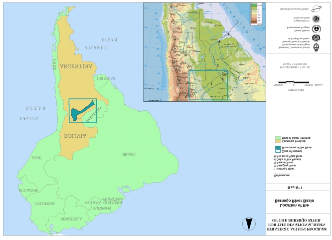
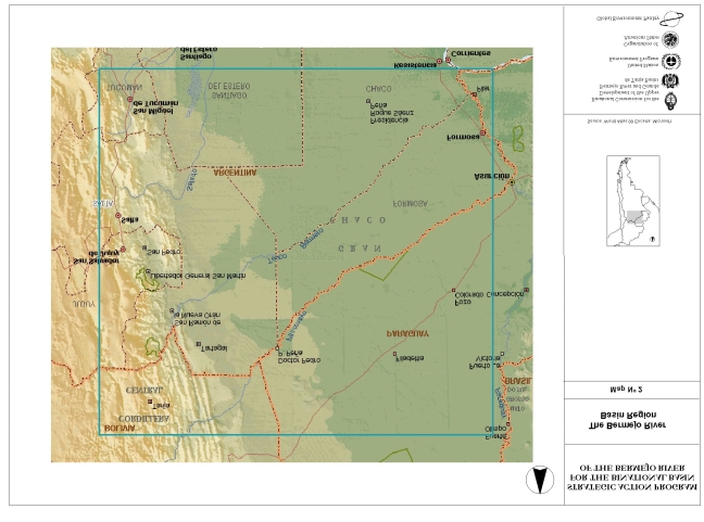

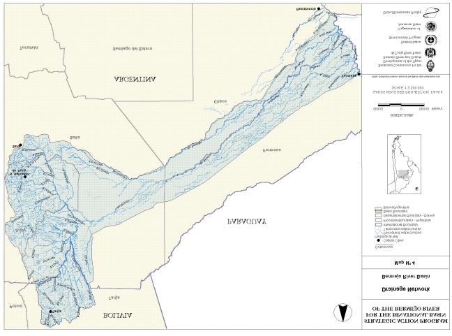
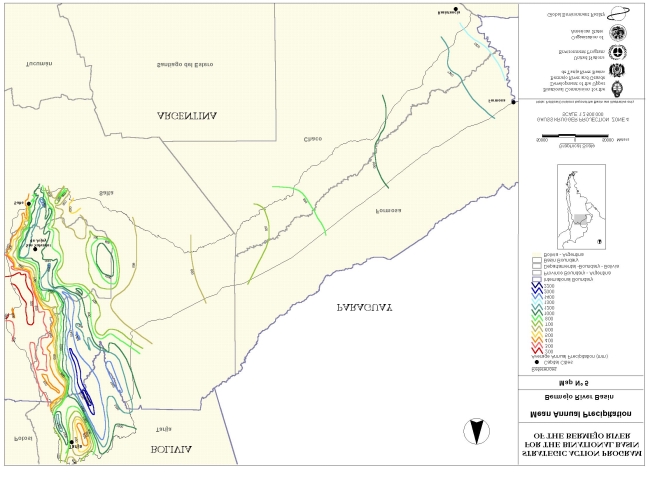

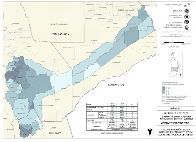

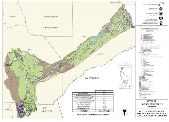
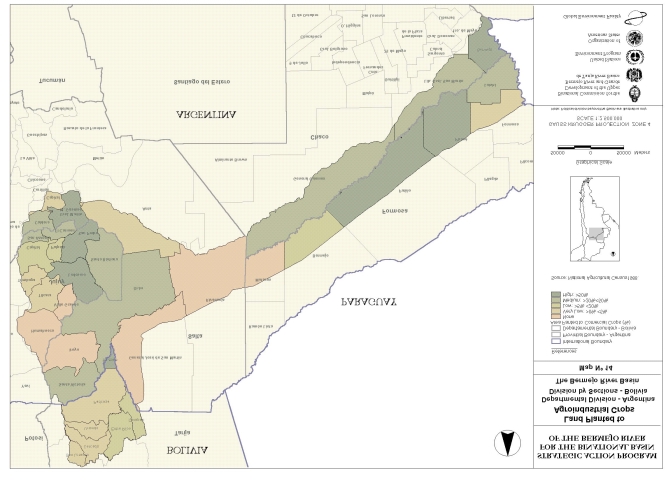
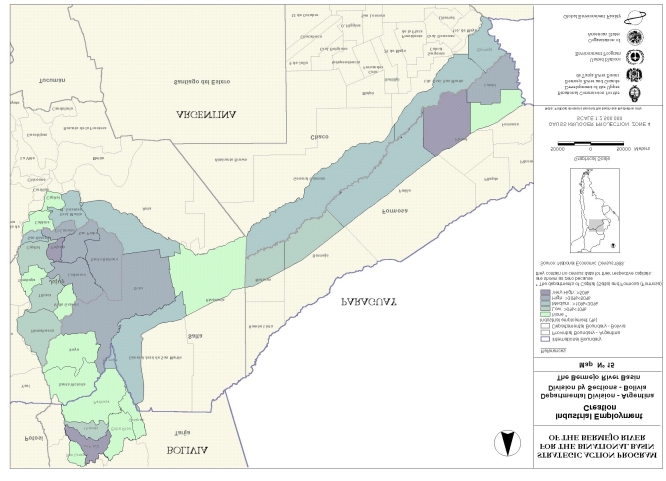
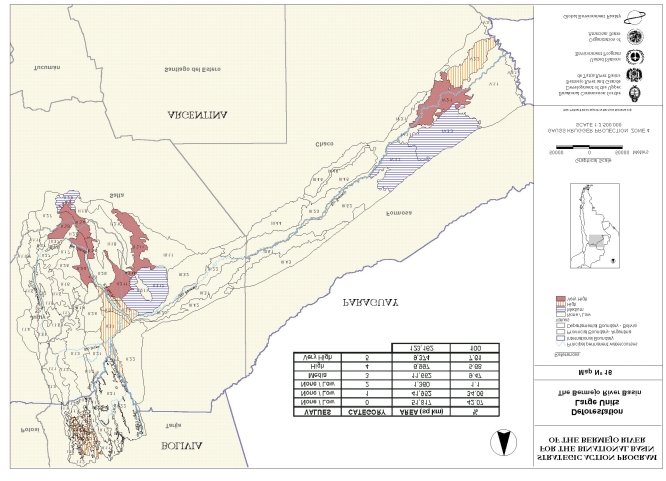

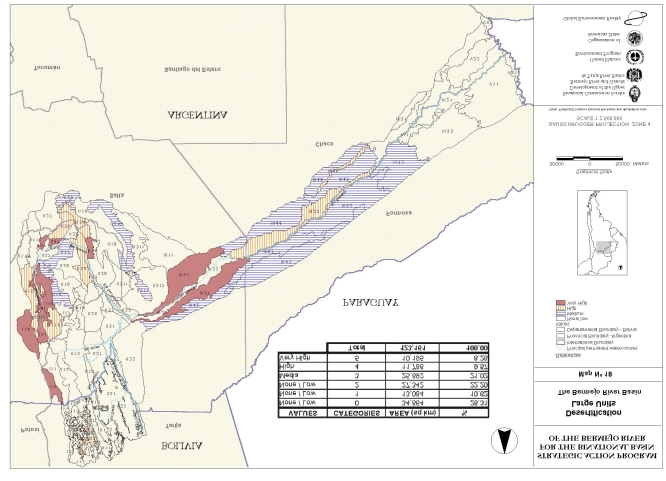


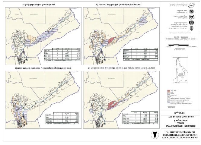
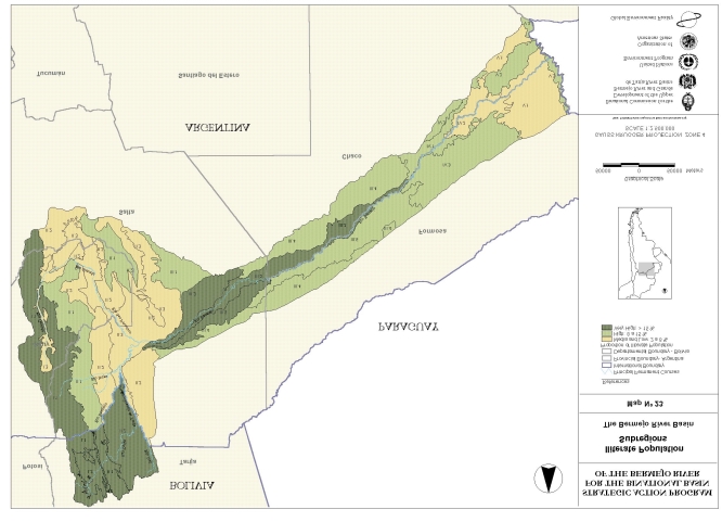
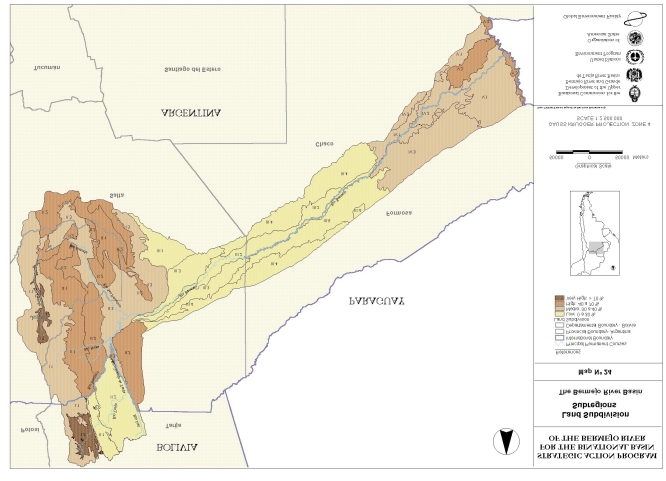
6. LIST OF ACRONYMS
CSA
Common Strategic Action
DSA
Direct Strategic Action
ISA
Indirect Strategic Action
AGAS
General Water Administration, Salta, Arg.
NPA
Nature Protected Area
APA
Provincial Water Administration, Chaco, Arg.
APN
National Park Administration, Arg.
Arg/AR
Argentina Republic
Bol / BO.
Republic of Bolivia
CONAPIBE
National Commission of the Pilcomayo and Bermejo Rivers, Bol.
CONICET
National Council of Scientific and Technical Research, Arg.
COREBE
Bermejo River Regional Commission , Arg.
EAP
Explotaciones Agropecuarias
El.
Work Program Element
EVARSA
Resources Evaluation S.A. Arg.
FMAM
Global Environmental Facility (GEF)
FONPLATA
Financial Fund for La Plata River Basin Development
GEF
Global Environmental Facility
GTG PEA
Governmental Working Group for the Formulation of Bermejo SAP, Arg.
GU
Large Ecological Units (see Regional Ecology)
IDH
Index of Human Development
IGM.:
Army Geographical Institute, Arg.
INA.
Water and Environment National Institute, Arg.
INDEC
Statistics and Census National Institute, Arg.
72
INTA
Agricultural Technology National Institute, Arg.
LIEY
Laboratory of Yungas Ecological Research, Arg.
MERCOSUR Southern Common Market
NBI
Basic unsatisfied needs
OEA
Organization of American States
ONG
Non governmental organization
PEA
Strategic Action Programme (SAP)
PBG
Gross Geographic Product
PNUMA
United Nations Environment Programme (UNEP)
PPP
Public Participation Program
PROMETA
Environment Protection , Tarija, Bol.
SCS-USA
Soil Conservation Service, USA
SRNyDS
Secretary of Nature Resources and Sustainable Development (now SPAyDS
Secretary of Environmental Policy and Sustainable Development), Arg,
TDA
Trasboundary Environmental Diagnostic
UBA
University of Buenos Aires, Arg.
UCS
Catholic University of Salta
UDSMA
Unit of Environment and Sustainable Development
UICN
International Union for Nature Conservation (UICN)
UJMS
Juan Misael Saracho Autonomous National University, Bol.
UNNE.
Northeast National University, Arg.
UNJU
Jujuy National University, Arg.
UNSA
Salta National University, Arg.
UNT
Tucumán National University, Arg.
WWF
World Wildlife Found
73
ZONISIG
Agro-Ecologic Zoning and Establishment of a Data Base and Geographic
Information Systems Network Project, Bolivia
74
ANNEX I
WORK PROGRAM ELEMENTS
ANNEX I
WORK PROGRAM ELEMENTS
Work Program Element 1.1: Transboundary Pollutant Movement, Binational. The objective
of the project is to determine the regional impact of the transport of sediments/pollutants
generated in the basin into Paraguay-Paraná and La Plata rivers waterways and Delta.. The
study comprises: a) elaboration of digitalized thematic cartography into a Geographic
Information System environment; b) Mapping of erosion prone areas to estimate sediment
production in the Upper Bermejo Basin; c) definition of quantitative flow and sediment transport
scenarios; d) implementation and exploitation of a mathematical model of the river. In addition,
possible measures to ensure environmental sustainability are analyzed.
Work Program Element 2.1: Stream Classification, Bolivia. This is a project to establish
criteria and parameters of classification of water courses within the Upper Bermejo Basin and
optimize use and quality control. Work to be done consists of sampling of water courses,
laboratory analyses, processing and evaluation of data, classification of water courses, definition
and regulation of water uses and preparation of guidelines for use and conservation of water
resources.
Work Program Element 2.2: Erosion Control-Santa Ana/Camacho, Bolivia. This project
consists of updating existing studies and experiences for control of erosion, land reclamation,
and management of natural resources. The studies are: a) Analysis of soils, vegetation, cattle
management, and agriculture, and a social-economic survey; b) Formulation of a plan for the
management of natural resources and erosion control c) Identification of demonstration areas,
and botanical species suitable to the area.
Work Program Element 2.3: Land Tenure-Tarija Valley, Bolivia. This study is to determine the
use and ownership of eroded land within the Tarija Valley. Work required will consist of: a
cadastral survey of the land; a census of owners of eroded land; legal characterization of
property; and usage and conservation of land.
Work Program Element 2.4: Range Management-Tarija Valley, Bolivia. This is a project for
zoning of natural grazing fields in accordance to their potential. It will establish sustainability
criteria, limiting the number of cattle allowed in each grazing field. In order to do so, it is
necessary to prepare an inventory of natural flora and fauna, evaluation of the potential for
raising cattle in the area, detailed cartography indicating zoning and natural units of grazing
fields, and establishment of strategies for the control of quantity of cattle grazing in the area.
Work Program Element 2.5: Land Use in the Lower Bermejo River, Argentina. The aims of
this study are a) understand and evaluate the Bermejo River fluvio-sedimentologic dynamics and
its water regimen, estimating its effects on the geomorphology of the valley, and the social-
economic and ecological consequences; b) provide information and criteria for an
environmental zoning of the areas affected by said dynamic, so as to identify management
Annex 1 - 1
alternatives and elaborate recommendations. Digitalized thematical maps will be prepared, in
order to characterize the natural resources baseline.
Work Program Element 2.6: Management of Forage- Humid Chaco1, Province of Formosa,
Argentina. This is a project of strategic value in the humid and sub-humid areas of the Chaco.
In this area there are some two million hectares of land infested by vinal2, affecting
predominantly middle sized and small farmers. The objective is to determine the costs of utilizing
practices for the control of vinal under farm conditions, and establishing the economic benefits to
the farmer of the recuperation of productive levels in cattle ranching. The Experiment Station
INTA-El Colorado has developed management procedures for vinal utilizing water from seasonal
waterbodies. Use of those procedures is the only way to ensure protection of the habitat for
numerous species of local flora, especially those of natural pastures. A small group of farmers
will introduce those practices in their farms.
Work Program Element 3.1: Transition Forest-Salta3, Argentina. This project aims to design
ecotourism demonstrative approaches that involve Transition Forests areas in the Yungas,
within the "El Rey" National Reserve Project area, in order to propose sustainable alternatives to
cope with degrading practices carried out in the region. The implementation of this
demonstrative project includes the supply of equipment and infrastructure, training of human
resources and the initial public divulgation of the project. This project is carried out with the
participation of the National Parks Administration, governmental institutions, provincial NGOs
and local owners.
Work Program Element 3.2: Tolomosa Watershed, Bolivia. This is a demonstration project for
land reclamation, control of sediments, reforestation and sustainable management of soils and
water. The feasibility study for this project is concluded. Interventions at the "Quebrada de La
Tablada" micro-watershed will be carried out through two components: engineering works for
sediment control and agro-forestry and others sustainable practices. The execution of this
project will allow the determination of the costs of the whole project and sediment abatement
measures effectiveness to be taken at Jacinto reservoir.
Work Program Element 3.3: Sustainable Development. Yungas,4 Salta, Argentina. This
project, to be developed by a group of small farmers in an area in the vicinity of Los Toldos, will
draw upon the experience of the Laboratory for Ecology Research in the Yungas (LIEY-
University of Tucumán). The main objective of this project is to mitigate the antropic pressure on
natural resources. It intends to integrate the farmers families into the regional market, generate
local employment alternatives, improve the education level of the schools in the area, and
search for sound sustainable management of the natural forest resources, within a multiple use
criterion, that can be applicable to other communities of similar social-economic and ecological
conditions. The GEF support will provide for the technical and economical assessment of the
implemented practices.
1 The Chaco region is an extensive area of plains located in the central part of tropical and sub-tropical South
America, covering approximately one million square kilometers, in parts of Argentina, Paraguay and Bolivia.
2 Vinal (Prosopis ruscifolia), a woody invasive tree or shrub in the Chaco region, is a close relative to mesquite
(Prosopis juliflora).
3 Transition forests are located in the plains, in the ecotone between Subandean montane rain forests and dry
forests of Chaco.
4 The Yungas ecosystems are montane cloudy forests located in the primary slopes of the Andes.
Annex 1 - 2
Work Program Element 3.4: Removal of Constraints-Dry Chaco and Humid Chaco. Province
of Chaco, Argentina. The adoption of practices of sustainable use of natural resources are
constrained by both the lack of land title and the poor quality of surface and groundwater during
the dry season in the Dry Chaco and by floods in the Humid Chaco. The objective will be to
promote public participation through demonstrative projects that will solve those constraints,
determine the costs of their removal and the benefits of introducing adequate management
practices.
Work Program Element 4.1: Hydrometeorological Network, Binational. This is a project for
the design of a complete binational hydrometeorological network and the rehabilitation of the
existing network in the Upper Bermejo River Basin, in order to obtain reliable and continued data
needed for monitoring the basin.
Work Program Element 4.2: Environmental Law, Binational. In Bolivia this study will promote
the establishment of a legal framework harmonizing laws for sustainable development in critical
eroded areas, creating legal conditions for policies, actions and interventions by landowners and
public and private institutions within the basin. Bolivian existing environmental laws and their
causes and their applicability will be determined. In Argentina the objective is to analyze the
present situation of the existing environmental institutional and organization setup, to propose a
desirable and feasible model for environmental management and elaborate proposals to be
considered in the formulation of the SAP. The SAP project will be one of the first activities in
implementing the Treaty on Environment between Argentina and Bolivia. It will also be analyzed
the situation of existing laws and treaties in relation with the Oran Agreement and the activities
and competences of the Binational Commission.
Work Program Element 4.3: Ecological Corridor-Baritú/Tariquía, Binational. This study will
focus on the optimization and conservation of flora and fauna through the formulation of joint
policies in the territory between Baritú and Tariquía natural protected areas to preserve
biodiversity conditions and the equilibrium of the ecosystem. Planned activities comprise an
analysis of the legal and institutional framework concerning Baritú and Tariquía; an inventory
and ecological complementation of both reserves; the formulation and analysis of alternatives for
the installation of a biological corridor; and the evaluation of the physical, legal and biological
feasibility of the corridor.
Work Program Element 5.1: Transboundary Migration, Binational. This is a study to
determine the temporary and permanent transboundary migrations so as to establish the role of
migrations in the use, conservation and sustainable development of natural resources within the
Bermejo Basin. Work needed is compilation of statistical information and social-economic
conditions of the transboundary migrations; social, economic, cultural and anthropological
surveys, establishment of patterns of temporary and permanent migrations; and an analysis of
the relation among migrations and the management and use of resources.
Work Program Element 5.2: Environmental Education-Formosa, Argentina. The purpose of
this project is to promote and contribute to build up environmental awareness through forest
cultivation in selected schools and communities in Eastern Formosa. Forests in this area are
affected by a process of degradation due to poor management practices. The objective of this
Annex 1 - 3
project will be to show the local population that costs of management practices are justified by
the productive recuperation of native forests.
Work Program Element 6.1: Formulation of the Strategic Action Program, Binational.
Formulation of a SAP is the main activity. It consists of the identification and harmonization of
development initiatives in the Bermejo Basin, followed by an strategic integration and
rationalization of those initiatives and the proposals for sustainable development in the region. It
will include an environmental evaluation of the basin, emphasizing the analysis of transboundary
problems, and a socioeconomic survey reviewing environmental practices and their relation with
the education, health, income and organization of local population. Support to Government
efforts at introducing environmental considerations into the laws and regulations at the national
and regional levels is a part of SAP
Work Program Element 6.2 Public Participation, Binational. This is a program of seminars,
courses, workshops and publications designed to engage the active participation of the many
communities living in the Bermejo River Basin, in order to increase the awareness of inhabitants
in relation to environmental concerns, avoid the disruption of the ecological balance and
promote the protection of their habitats. Most of the SAP components will also incorporate
specific activities of participation or public consultation.
Annex 1 - 4
ANNEX II
BASIC ENVIRONMENTAL DATA
1
ANNEX II
BASIC ENVIRONMENTAL DATA
1. THE NATURAL ENVIRONMENT
1.1 Hydrography
1.2 Geology and geomorphology
1.3 Climate
1.4 Hydrology
1.5 Water quality
1.6 Transportation of sediment
1.7 Soils
1.8 Vegetation
1.9 Wild animals
1.10. Nature conservation
2. LEGAL AND INSTITUTIONAL FRAMEWORK
2.1 Political and institutional framework
2.2 National and Sub-national (Provincial) Level
2.3 Regional Level
2.4 Binational Level
3. SOCIOECONOMIC ASPECTS
3.1 Social aspects
3.2 Economic aspects and production
3.2.1 Land use
3.2.2 Subdivision of the land
3.2.3 Soil use with agroindustrial crops
3.2.4 Generation of industrial employment
3.2.5 Industrial establishments and generation of industrial value added
3.3 Road infrastructure
3.4 Transboundary migration
3.5 The basin and its region: Economic Reconstruction Territories
3.6 Conclusions
4. ECOLOGICAL REGIONALIZATION
4.1 Background and methodology
4.2 Ecological and Socioeconomic Characters
4.3 Environmental zoning
2
LIST OF FIGURES
Figure I
Rate of production of sediment by erosion in the Upper Basin
Figure II
Areas most susceptible to generation of mass movement to the Upper
Basin
Figure III
Registers of rainfall stations in the subsidiary basins of the Tarija and
Bermejo rivers
Figure IV
Flows of the Bolivian sector or shared between both countries
Figure Iv a: Liquid flows
Figure IV b: Solid flows
Figure V
Map of the slopes of the Upper Basin
Figure VI
The Basin and its Region
LIST OF TABLES
Table 1
Land distribution in the Basin
Table 2
Water quality, Bermejo River Basin, Bolivia
Table 3
Water quality, Bermejo River Basin, Argentina
Table 4
Solids suspended in the Bermejo River
Table 5
Capacity of soil use in the soils of the Basin
Table 6
Vegetation patterns in the Basin
Table 7
Eco-regions and dominant types of vegetation
Table 8
Species of endangered wild animals for conservation, by eco-region
Table 9
Protected natural areas and marshes
Table 10
Legal framework and standard institutional regulations
Table 11
Characteristics of the population
Table 12
Soil use in the Bermejo Basin
Table 13
Subdivision of land and area with industrial cultivation
Table 14
Generation of industrial value added, density of industrial establishments,
and generation of jobs in the industrial sector
Table 15
Classification in Eco-regions, Subregions, and Large Units
3
BASIC ENVIRONMENTAL DATA
The following data present an environmental profile of the basin, showing the major sectoral
aspects of the natural environment, the socioeconomic setting, and the existing legal and
institutional framework. The Work Elements developed by the SAP Project are presented in
Annex I while the corresponding documents and final reports, produced between 1997 and
1999, are listed in Chapter 4 of the main text. The numerical refrence to said documents is
placed among brackets along the texts.
1. THE NATURAL ENVIRONMENT
This binational basin is marked by active and intense hydrological, geomorphic, and ecological
processes, with significant potential in terms of natural resources, variety of ecosystems and
biodiversity. But it also has strong environmental limitations and risks, both bio-geophysical and
social. This situation -- and the need to take energetic development measures to improve the
quality of life of the people, in a context of the lack of policies and management and
development instruments with a broad enough view of the basin to properly understand these
problems were the basis of GEF's decision to assist the governments in drawing up a SAP for
the Bermejo River Basin, in the focal area of the GEF of International Waters.
There was a compilation and synthesis of environmental information on the basin, on the basis
of an Ecological Regionalization (31), which then became the framework for the analysis of a
set of indicators of natural and socioeconomic conditions and related limitations. The territory
was divided into hierarchically related spaces on the basis of differing environmental
characteristics that were homogenous at each corresponding level. For this purpose we
basically used the Subject Mapping (Figure 9, and the documents 1, 13, 37), generated on the
basis of interpretation of satellite images and other sources of information. It was possible to
identify 5 Eco-regions, 17 Subregions, and 68 Large Ecological Units (in addition to six
around the basin). The following information describes the principal aspects of the environment
in general, and specifically the water resources, in the context of the problems identified.
1.1. Hydrography
The River Bermejo Basin, shared by Argentina and Bolivia (Figures 3 and 4), is an important
area in the macro-region of the River Plate Basin. Its area is 123,162 square kilometers (Table
1) and its principal course is more than 1,300 kilometers long. According to its characteristics, it
can be divided into the Upper Basin and the Lower Basin. Various aspects of the water
resources have been analyzed in (1, 2, 3, 4, 13, 14, 23)..
In Bolivia, the Upper Bermejo Basin is found in the extreme southern part of the country, totally
within the Department of Tarija. It covers an area of 11,896 square kilometers. The rest of the
Upper Basin and all of the Lower Basin are in Argentina, in the extreme center-north of the
country, occupying part of the provinces of Chaco, Formosa, Jujuy, and Salta, with an area of
111,266 square kilometers.
The Upper Basin (50,191 square kilometers) represents the active basin of the Bermejo river. It
specifically encompasses the central and southern parts of the Department of Tarija in Bolivia,
nearly all the province of Jujuy, and the northern and eastern parts of the province of Salta to the
Annex II - 1
confluence of the San Francisco river and the Upper Bermejo river itself. In this part of the Basin
75.6% of the area is in Argentine territory and 24.4% is in Bolivian territory.
Table 1
TERRITORIAL DISTRIBUTION OF THE BASIN
JURISDICTION
AREA
PROPORTION
km2
(%)
COUNTRY
BOLIVIA
11,896
10
Department
Tarija
11,.896
10
COUNTRY
ARGENTINA
111,266
90
Provinces
Chaco
19,47
16
Formosa
26,445
21
Jujuy
21,053
17
Salta
44,521
36
TOTAL
123,162
100
The hydrographic network is composed of four main tributaries: the Tarija Grande river, the
Upper Bermejo river, which after Juntas de San Antonio is called simply the Bermejo, the
Pescado river, and the San Francisco river.
The Tarija river, situated entirely in Bolivia, originates in the Sama ridge, and near its source is
called the Guadalquivir. After the confluence with the Camacho river, it is called the Tarija. From
there it continues predominantly in a northwest-southeast and north-south direction to its
junction with the Itaú river. The principal sources in the north are the Salinas and Chiquiaca
rivers, and in the south the Pampa Grande river. From its confluence with the Itaú it is called the
Tarija Grande river, and it forms the border between the two countries, until Juntas de San
Antonio.
The Bermejo river also arises in Bolivia, in the vicinity of Padcaya. Initially it is known as the
Orosas until in meets the Condado river, and then is called Bermejo where it begins to take a
northwest-southeast direction to the confluence with the Tarija river. This last sector is a border
and receives input from the Lipeo and Toldos rivers on the right bank (Argentina), and the
Emborozú and Guandacay rivers on the left bank (Bolivia).
After Juntas de San Antonio, the Bermejo river, fully within Argentine territory, continues in a
northwest-southeast direction and receives on its right bank the flow from the Pescado river and
the Blanco or Zenta and Colorado rivers. It should be noted that the Pescado river basin
includes, since 1865, the waters from the Iruya river basin, which was diverted at that time to
prevent flooding in the city of San Ramón de la Nueva Orán, because that basin is a main
source of sediment.
In the southern part of the region, the San Francisco river takes its name in the final section after
the juncture with the Grande river, which has the longest trajectory in this sub-basin, completely
within the province of Jujuy with sources in the ridges of Chani, Aguilar, and Santa Victoria and
Annex II - 2
is initially known as the Quebrada de Humahuaca. Its tributaries on the left bank are longer than
those on the right bank. The most important are the Calete, Yacoraite, Huasamayo, Volcán,
Lozano, Yala, Reyes, and Perico. The inter-provincial Lavayén river is a tributary of the Grande
river on its right bank from the south-southeast, fed by the Mojotoro river that flows entirely in the
province of Salta
The Lower Basin (72,971 square kilometers), total y within Argentine territory, is marked on
both sides by the winding course of the Bermejo river1/ in the eastern part of the province of
Salta. After crossing its boundary it becomes the border between Formosa and Chaco until it
empties into the Paraguay river (Figures 3 and 4).
In the Lower Basin, it should be noted that from the place called Desemboque, the Bermejo river
changes its name to Teuco, because from there toward the southern shore flows the old bed of
the Bermejo. This is fed by others, diverting from the Quirquinchos and Zanja del Saladillo
swamplands, which receive water from the important Dorado and del Valle rivers and an
extensive network of ravines. There is an important group of rivers, brooks, and streams that
eventually flow into the Bermejo river or are fed by its overflows. In the province of Formosa, we
could note the Teuquito river on the northern shore, the Dobagán, Mbiguá, and Lindo brooks
and the Salado, Saladillo and Negro runs. In the Chaco province, on the south shore, it feeds
the Bermejito, Muerto, and Oro rivers, the Guaycurú, Guaycurú Chico, Cangui, Cangui Chico,
and Zapirán brooks, and the Guaycurú, Salado, and Nogueira runs. In this whole region of
intermittent courses and pools there has to be a great amount of mingling of the surface runoff in
the floodable areas and underground drainage. (Figure 4).
1.2. Geology and Geomorphology
In Bolivia, the basin is divided into two geomorphic regions: the Eastern range of the Andes, and
the Sub-Andean ridge, which continue in Argentina, where there is a third region, the Chaco
Plain, with the largest area. In the Bolivian sector the eastern range is found in the water
systems of Sama and Cóndor (3,000 to 4,600 meters), which border the central valley of Tarija,
which has a river plain at the bottom. In Argentina, there is the Santa Victoria Sierra, which in
the south is divided by the Quebrada de Humahuaca. It is a rugged, rocky range with maximum
elevations of 6,200 meters. The sub-Andean ridge, which has the eastern Andes on the west
and the Chaqueńa plain on the east, runs in a north-south direction with an elevation of about
2,000 meters above sea level. In the Bolivian part of the basin, the drainage is greatly affected
by the tectonics, with rivers in the sinkholes. In the Argentine sector the drainage system has a
sharp west-to-east thrust. In the extreme southeast of the basin, the Santa Barbara Sierra (2,500
meters) borders the broad valley of the San Francisco river.
Initially, an ancient alluvial conoid formed from Juntas de San Francisco to the southeast,
covering the Chaco Bajada to below the Barilari Line, in contact with the conoids of the Valle
river and the Tartagal river, and on the north with the Pilcomayo. Later, the river must have
advanced over its old sediment and formed the large conoids of the north and south of the
present valley, which we have called the Conoid of Bermejo Salado and the Conoid of Bermejo
1.The constantly changing course of the river creates a whole set of situations that are difficult to interpret
with traditional tools. The beds of the tributaries and frequent and imprecise overflows vary in space and
time, not always at the same place because of the effect of the unusual adjacent topography. This
includes deactivated beds, filed in with sediment, or intermittent streams with no outlet that end in pools
and extensive surfaces for reception and transpiration through the existing vegetation.
Annex II - 3
Guaycurú. In this whole area it is easy to recognize the buildup that extends like fingers over the
plain and is directly linked with the upper high cloudy forest.
The Eastern Andes and the Sub-Andean ridge contain sectors that are extremely active from
the geomorphic point of view. The process of generation of sediment, which affects substantial
areas, has been studied in all of the Upper Basin by (2), by means of a simulation model2/ so
Figure 1 presents one of its findings, the Rate of Sediment Production from Surface Erosion. It
should be noted that this study has comparable value in the overall Upper Basin environment.
By contrast, Figure II presents in qualitative form the Areas Prone to Generate Massive Land
Movements for the Argentine Upper Basin (for example, landslides and large movements of
hills). This process is one of the major contributing factors to sedimentation in the basin, and
constitutes a natural threat of environmental risk for local settlements, many of which are poor.
Some sectors have such complex and intensive shifts that they are being given special study, as
in the central valley of Tarija, the Iruya river basin, and Quebrada de Humahuaca.
Significant amounts of material accumulated in the Upper Basin are carried by the river system
toward the Lower Basin, where the plains serve as the major recipient of medium and heavy
material. Fine material is carried downstream, outside the basin. Various agents have sculpted
the area (polygenic plain), but the primary ones are those associated with rock movement. This
is evident in the complex matrix of geomorphic units that affect drainage, soils, and vegetation.
In very recent eras, the Bermejo river underwent many shifts of position, covering an area that
we call the plain of digression. Even today, the entire plain is very active from a geomorphic
standpoint.
1.3. Climate
The Basin is located in a transition climate zone.3/ This is especially evident in the Upper Basin,
where in a short distance one encounters significant variations, from a cold semi-arid montane
climate in the west, to a tropical humid climate in the east. The mountain mass is an important
factor affecting circulation of air masses in the region. Maximum precipitation,(according to (1), is
found in the sub-Andean Eco-region, with more than 2,200 millimeters per year, diminishing
toward the west to 200 millimeters (Eastern Andes Eco-region) and toward the east to 600
millimeters in the center of the Semi-arid Chaco Eco-region, and increasing to 1,300 millimeters
in the sector of the confluence with the Paraguay river, in the Humid Chaco Eco-region (Figure
5).
Elevation and longitude from the Upper Basin in the northwest to the Lower Basin in the
southeast presents a heterogeneous climate pattern, with the following variations:
2. The results of the application of this simulation model have been properly compared. See a breakdown in (2).
Figure 1 shows spatially only the intensity of the rate of production of sediment from surface water erosion. There
could be other erosive factors that are not reflected in the model.
3. The region as a whole is influenced by subtropical cyclones and by the interruptions caused by the formation of
a low pressure center in the Andes mountain range.
Annex II - 4
·
Cold Zone: located at elevations above 2,700 meters above sea level, where the
following two climates are found cold: semi-arid and cold sub-humid.
·
Temperate Zone: at elevations of between 1,500 and 2,700 meters above sea
level, with climates that are temperate arid, temperate semi-arid, temperate sub-
humid, and temperate humid.
·
Warm Zone: covers the whole eastern area of the basin, the Sub-Andean zone
and the Chaco Plain, where four climate types are found: warm sub-humid, warm
humid warm very humid, and warm semi-arid.
It should be noted that there are large sections of the territory in the basin that are short of water.
These are in the Eco-regions of the Eastern Andes (with dry spots as in the Valle Central de
Tarija and especially the Quebrada de Humahuaca) and the semi-arid Chaco, as shown in
Figure 5 the average annual distribution of rainfall. This restriction in the environment is
compounded by the growing shortfall and seasonality of rain from the Eco-region (from east to
west), with a growing period of drought. This climatic condition results in limitations on use. The
drought conditions, combined with torrential rains in the context of the unstable contours lead to
the occurrence in the Upper Basin (especially in the Eastern Andes Eco-region) of natural
threats such as mass movements of all types (landslides, mudslides, avalanches, etc.) as well
as the processes of surface water erosion.4/
Another important aspect associated with climate is the great inter annual variation in rainfall,
with extreme heavy rains and drought periods . This situation is reflected in (35) in the registers
of the rainfall stations located in the sub-basins of the Tarija and Aguas Blancas rivers, shown in
Figure III, with variations of between nearly 750 mm. (1988) and 2,100 mm (1959) for the same
rainfall measuring station.
1.4. Hydrology
The hydrological regime of the rivers is controlled by rainfall, and as such presents clearly
delineated seasonal variations, with a period of heavy flow in the rainy season, with up to 75% of
the flooding between January and March (reaching 85% in the entire season), and another
period of light flow in the dry season (April to September, when it drops to as low as 11%).
Flow data for the Bolivian sector or that shared by both countries, measured in the respective
gauging stations, are shown in Figure IV.
As for the Bolivian sector of the Upper Basin, during the period in question the average flow
of the Bermejo river, at Aguas Blancas, was 92 cubic meters per second, while the average flow
of the Tarija Grande river, at Algarrobito-San Telmo, was 127 cubic meters per second. The
specific slowest flow was recorded in the basin of the Santa Ana river in the Central Valley of
Tarija, with 2.8 liters per second (square kilometer), and the heaviest was found in the Emborozú
sector with 27.5 liters per second (square kilometer).
4.Castro, H, Arzeno, M, 1999. Environmental risk in the Quebrada de Humahuaca: components,
perceptions, and responses. Institute of Geography, University of Buenos Aires.
Annex II - 5
On the basis of available information, and correlating the specific flows with the average rainfall,
the availability of water for every sub-basin, and for characteristic sections of the main rivers,
was calculated.
Minimum flows in the Tarija valley rivers are completely used in irrigation and drinking water, so
the minimum flows of the Tarija Grande river registered before the confluence with the Bermejo
(Juntas de San Antonio) basically comes from the subbasins of the Sub-Andean region. This
arrangement changed after 1988, with operation of the dam of San Jacinto, which increased
natural minimum flows on the order of 10 to 20%.
As for the Argentine sector of the Upper Basin, on the basis of available data (EVARSA,
Hydrological Statistics, Volume I, 1994, MeyOySP, 1994) the average annual flow of the
Bermejo before Junta de San Antonio is 92 cubic meters per second, with a specific value of
18.2 liters per second (square kilometer), while the data for the Tarija Grande river before its
confluence with the Bermejo is 127 cubic meters, with a specific flow of 12.4 liters per second
(square kilometer), and the average annual flow at Junta de San Antonio is 219 1 cubic meters
per second, of which 56% is from the Grande Tarija river and 44% from the Upper Bermejo.
(Figure IV).
Annex II - 6
FIGURE IVa
LIQUID AND SOLID FLOWS IN THE UPPER BERMEJO BASIN
LIQUID FLOWS:
BS 19 %
GT 26 %
92 m3/s
127 m3/s
P 10 %
49.6 m3/s
IR 12 %
57.3 m3/s
Bermejo river 100%
480 m3/s
BL 4.6 %
22.1 m3/s
SF 21 %
101 m3/s
Legend:
GT:
Tarija Grande river.
BS:
Upper Bermejo river.
P: Pescado
river.
R: Iruya
river.
BL: Blanco
river.
SF:
San Francisco river.
Source:
EVARSA (1994) and others
Annex II - 7
Figure IVb
LIQUID AND SOLID FLOWS IN THE UPPER BERMEJO BASIN
SOLID FLOWS:
BS
GT
P
IR
Río Bermejo
BL
SF
FLOWS
GT
BS
P
IR
BL
SF
Bermejo
Solid flow (106 tn)
12.96
8.64
5.76
36.72
7.92
18
90
Solid flow (%)
14.4
9.6
6.4
40.8
8.8
20
100
Specific solid flow
1,239
1,781
3,388
12,447
1,571
698
1,772
(tn/km2 .year)
Watershed Surface
10,460 4,850
1,700
2,950
1,571
25,800
50,800
(km2)
Legend:
GT: Tarija Grande river. BS: Upper Bermejo river. P: Pescado river. IR: Iruya river. BL: Blanco
river. SF: San Francisco river. Bermejo: water below Juntas de San Francisco
Source: EVARSA (1994) and others
After the confluence of the Pescado and Blanco rivers, the module of the river reaches 347 cubic
meters per second. With the input from the Grande-San Francisco system, whose module is 101
cubic meters per second and specific flow is 3.91 liters per second (square kilometer), the
Bermejo river attains 448 cubic meters per second, which is the contribution of the water from
the Upper Basin to the Lower Basin.
In the Lower Basin, evaluations of the monthly flow in El Colorado, with a module of 386 cubic
meters per second and a specific flow of 5.88 liters per second (square kilometer) mean the
hydrogram shows a displacement of the cresting wave for the months of February to April, and
Annex II - 8
the low point from the months of June to December. An analysis of the data shows that the area
contributing the greatest specific flow is the sub-Andean sector (in the Upper Basin of the
Bermejo river the specific flow in the Balapuca station is twice that at the Alarache station (40
kilometers upstream), which is in the sector with the highest rainfall in the entire basin.
In Bolivia, current use of the water of the Bermejo and Tarija Grande basins is limited to
irrigation of cultivated areas, human consumption, and for livestock. The estimate of current
demand ( based on the irrigated area and the total of the present population) is approximately
110 hm3/year, which is smaller than 2% of the volume available in the basins. However,
considering the natural minimum flows (in the month of September), current use is nearly 100%
of the available flow of the rivers in the entire inter-Andean region, especially in the sector of the
central valley of Tarija, which is where the highest population concentration is found, and the
largest area of irrigated crops. In the central valley of Tarija there is only one dam for regulating
the flow, the San Jacinto dam, located on the course of the Tolomosa river, which has a useful
storage capacity of 48.7 hm3 with a basin of 432 square kilometers. This is a multiple use dam
(generation of electric power, irrigation, and drinking water for the city of Tarija).
In the Argentine sector of the basin, the main use of the water resources of the Bermejo system
is for the development of low irrigation crops (cotton, soybeans, rice) and the supply of water for
human consumption and livestock. In Jujuy the Las Maderas and La Ciénaga reservoirs,
together with Los ;Molinos diversion damon the Grande river, supply irrigation water for the
Pericos valley system, as well as potable water and electric power generation. The flooding that
drains the piedmont areas of the Upper Basin in Salta and Jujuy are used to support local
irrigation networks. In the section of the Lower Basin water is diverted for irrigation and drinking
water, as is the case of the Laguna Yema system, in Formosa, or important private irrigation
systems, like the rice project currently under development in Chaco (much of it on the flood plain
of the Paraguay river).
Document (35) has studied the impact of the so-called climate change in the surface hydrology
of the basin on the basis of currently accepted premises. The estimates made indicate different
effects of the El Nińo phenomenon on the Upper Basin and the eastern edge of the Lower Basin
(sectors under the influence of the Paraguay river--River Plate basin). The phenomenon of El
Nińo--Southern Oscillation (ENSO) is one of the major variables in atmospheric circulation and
affects the main components of the water cycle, which are responsible for unusual floods and
droughts.
In the Upper Basin, the data from Aguas Blancas in the study on monthly levels show that the
occurrence of cold episodes in the Pacific Ocean (La Nińa) produce average monthly flows
slightly higher than the average for the month of March, and the hot episodes (El Nińo) produce
lower than average flows.
In the final stretch of the Bermejo for the Lower Basin and the area of influence of the Paraguay
river--River Plate, the effects of the extreme events of El Nińo and La Nińa are the opposite of
those in the Upper Basin. In fact, water flow data show higher volumes for the months of El Nińo
and lower volumes for the cold events (La Nińa).
This same study has examined the sensitivity of the water resources in the principal sub-basins
to the effects of the global climate changes on the rainfall and temperature in the region of the
basin. The various scenarios studied show a tendency toward increasing temperature and
Annex II - 9
evaporation as a consequence of the increase in carbon dioxide in the global atmosphere, which
would result over the long term in a reduction of flows. The San Francisco basin appears to be
the most sensitive to the effects of climate change.
1.5. Water quality
The large scale of these basins and the diversity of environmental and use conditions result in
widely differing water quality.
One of the variables is the hydrological system. During high flows in the wet season, a decisive
factor is turbidity, which is high and presents similar characteristics in all the rivers. In the
intermediate stages the quality is a factor of turbidity and the concentration of fecal coliforms,
which are much lower than in the dry season. During the dry season, the conditions become
more critical. Generally the water of the rivers in the basin has medium to low content of salts
and low indexes of sodium absorption, so the water is good for irrigation.
In Bolivia, for classification by suitability for consumption we have employed the criteria
established by the regulations of the Environmental Law No. 1333, and for classification by
suitability for irrigation we have used the Agriculture Manual of the Soil Conservation Service of
the United States.
The principal sections with low water quality (suitability D, not suitable for human consumption
with conventional treatment) are found in the following rivers: Guadalquivir (between Tomatitas
and the junction with the Camacho), Camacho (between Chaguaya and its junction with the
Guadalquivir), Salinas (in the Entre Rios-La Cueva section), Tarija Grande (from the confluence
with Quebrada 9 to the junction with the Bermejo), Bermejo (in the section Aguas Blancas-
gauging station to the junction with the Tarija Grande). The control points suggest similar
conditions of unsuitability (suitability D) for the quality of water in the following sites:
Guadalquivir river in the El Tejar zone and Camacho river in the El Mollar zone. The evaluation
of the quality in terms of suitability for irrigation shows that in Bolivia, of 20 sites sampled, 17
have medium salinity (no restrictions), two were highly saline or very saline, and only one was of
low salinity.
As a reference, (Table Nş 2), 28, out of 41, control sites surveyed in the Bolivian sector,
exhibited some degree of pollution (mainly bacteriological or due to organic matter). The
greatest organic pollution, obviously, is found in the sections of the rivers where there are
population centers, due to the dumping of semi-treated or raw waste water, and of waste water
from the sugar and alcohol industries.
In the Argentine sector of the basin, the data obtained from the control points indicate that of 14
sites sampled, six have some sort of restrictions on use, in all cases because of bacteriological
contamination (total and fecal coliforms), to which often must be added excessive concentrations
of iron or sulfates.
Annex II - 10
The latest census data available (1988)5/ indicate that in the Argentine basin, only 6% of the
area of farmland is used for crops, such as tobacco, beans, sugar cane, citrus, corn, and
sorghum, pastures, vineyards, timber, fruit, and cotton, which could potentially contribute with
runoff from pollutants associated with pesticides and/or inappropriate use of farming techniques,
as well as erosion that occurs naturally in the zone, reaching the Grande, Lavayén, and San
Francisco rivers and finally the waters of the Bermejo river. As shown in the map of soil use
(Figure 13), crops with the largest area are sugar cane, tobacco, and soybeans, which are
found primarily in the piedmont of the sub-Andean Eco-region. Overfarming or use of improper
techniques for the agrosystems can ruin the soil and contaminate the environs, affecting even
the river courses in the basin.
Available data for the basin in both countries, presented together in Tables 2 and 3 at the end of
this Annex summarize the classification of water control by monitoring stations.
1.6. Transportation of sediment
The study of cross-border transportation of sediment has been one of the points of interest of the
TDA in both countries (2 and 14). This is reflected in the generation of the model of production
of sediment by surface erosion in the Upper Basin (Bolivian and Argentine), and the
morphological model of the principal water courses in the Upper Basin and the Lower Bermejo.
The amount of sediment transported in the Upper Basin was estimated on the basis of
measurement of 24,000,000 tons per year up to Juntas de San Antonio, with roughly 15,500,000
tons per year corresponding to the Tarija Grande river and 8,500,000 tons per year to the
Bermejo river. Stated in terms of surface units of the basins, that is 1,400 tons per square
kilometer/year and 1,700 tons per square kilometer/year respectively. In the area of the basin
that was studied, surface erosion is the main producer of sediment. In the central valley of
Tarija, the amount of sediment that enters San Jacinto reservoir has been estimated at 1,697
cubic meters/square kilometer/year.
These amounts have been reasonably replicated in the sediment production model, which
indicate that the amount of sediment generated just by surface erosion and transported to the
border area of the Upper Basin (Juntas de San Francisco) is about 18,500,000 cubic meters per
year (corresponding to 49,000,000 tons per year). The 64% has its origin in Argentinean territory
and remaining 36% in Bolivian territory, according (2).
In the Argentine sector of the Upper Basin, in addition to the production model indicated, we
made a map of the areas of greater susceptibility to the processes of slippage, sliding, and rapid
mass movement (Figures I and II). The slope (Figure V) is one of the determining factors. The
Iruya, Pescado and Grande river of Jujuy are the sub-basins with the greatest propensity to
generate sediment.
Results of the production model indicate that the Argentine sector of the Upper Bermejo Basin
produces and transports to the edge of the basin 31,400,000 tons per year of sediment from
5. With regard to the currency of census data, Argentina is nearing the end of the inter-censal period.
Therefore the only information available at the departmental level is partially out of date. On the other
hand, the data from the provincial level are much fresher.
Annex II - 11
surface erosion, which added to the amount produced in Bolivia by the same source gives a total
of about 49,400,000 tons per year (the rest of the sediment transported is caused by mass
erosion).
The gauging stations for suspended solids that are most typical of the Argentine sector of the
Upper Basin, and the average annual amount and maximum monthly amount carried are shown
in Table 4.
The geographical identification in the spatial distribution of the rate of production of sediment in
the basin is shown in Figure 1, as a result of the application of the abovementioned
mathematical models.
The morphological models done for the Upper Bermejo river show the present situation of the
channel is relatively stable, with a probable tendency for erosion. In the section down water to
Juntas de San Francisco there is the opposite condition, with a tendency to movement based on
the heavy input of solids from the tributaries, the Tarija Grande, Iruya-Pescado, and Blanco
rivers, in the initial and central stretch, and the Santa Maria-Colorado and San Francisco rivers
in the final stretch.
As for the scenarios analyzed to evaluate the impact of the accumulation of solids in the rest of
the system, it is significant that there is little influence from the major reduction in the buildup of
sands in the basin that produces the most sediment, in the morphology of the section of the
Upper Bermejo river downstream, and the contribution of sand toward the Middle and Lower
basins of the Bermejo river.
Table 4
SOLIDS SUSPENDED IN THE BERMEJO RIVER
Name of river/Gauging Station
Total annual avg.
Monthly max.
suspended Solids,
suspended solids,
thousands of tons
thousands of tons
Bermejo / Alarache
5,023
2,268
Bermejo / Balapuca
8,062
4,163
Bermejo / Aguas Blancas
8,346
14,337
Iruya / San José
13,127
5,953
Iruya / El Angosto
35,.341
12,.265
Pescado / Pto Romero
5,312
3,186
Bermejo / Zanja del Tigre-Pozo
70,.508
34,138
Sarmiento
San Francisco / Caimancito
18,901
10,219
As for mud and clay, given the characteristics of the rivers of the network it is clear that the
transport of these elements is done as "washing load" in the entire Upper Bermejo river. In these
conditions the concentration of mud and clay is determined by the amount of these materials put
into the current, and not by its capacity to transport them.
This indicates that decreases in the amount of fine sediment carried will be reflected almost
without alteration at the exit from the upper basin, at Junta de San Francisco. Although this is
Annex II - 12
true in theory, in practice the situation is more complicated. There are other factors, such as
morphological changes, reincorporating fine sediment in the flood plains and banks, which
means there is indeed recovery of fine material.
About 80% of the material in suspension carried to the lower Bermejo at Junta de San Francisco
comes from the Upper Bermejo sub-basin, and the other 20% comes from the San Francisco
sub-basin. If we take into account the series of solid gauging stations at Pozo Sarmiento-Zanja
del Tigre (Bermejo) and Caimancito (San Francisco), we see that the former has an average
suspension of 70,508,100 tons per year (3,047 tons/km2 year), and the latter has 18,901,200
tons per year (720 tons/km2 year), which gives a total of 89,409,300 tons per year (1,811
tons/km2 year). This amount reaches 120 million tons per year when the ratio of solid/liquid flow
is applied to that of average monthly flow.
The morphological model has also been applied to the Lower Bermejo river, from Junta de San
Francisco to Route 11, in the vicinity of the communities of L.V. Mansilla (Formosa), and Colonia
Vélez (Chaco).
It has been established that the system in its present conditions appears to be in balance from
the viewpoint of solids transport. The scenarios for change in the solid input to the Lower
Bermejo at Junta de San Francisco that were studied were reductions in the addition of sand.
The result was that, as in the case of the Upper Basin, the sand level is rapidly recovered.
With regard to the impact of the reduction of fine particles in the Upper Basin, the possibility of
recuperation of mud is greater in the Lower Bermejo, because of the nature of its bed and
banks. However, the balances of the transportation of solids in suspension in the system could
be indicating slight significance for recovery of bottom mud and banks.
Finally we studied the influence of the variation in sediment load of the Bermejo river on the
Paraguay-Paraná-Delta-River Plate system. This led to interesting conclusions. In the first place,
the amount contributed by the Upper Bermejo and San Francisco was in practice the same as
that of the Lower Bermejo at El Colorado.
Analysis of the Paraguay-Paraná portion for the period studied (1969-89) revealed that the
former provides 94% of the total and the latter the remaining 6%. In the percentage
corresponding to the Paraguay river, 87% of the total corresponds to the Bermejo, whose share
has increased in recent years.
It should be noted that the time of data collection affects the amount of sediment reported, which
varies between 90,000,000 tons per year (for the entire period registered) and almost
123,000,000 tons per year (for the period 1969-89). The average can be considered about
100,000,000 tons per year, which is mainly the fine portion (basically mud and clay) of the
Bermejo river that is added to the Paraguay-Paraná river systems.
The National Water and Environment Institute (2 and 14) and other specialists (3) analyzed the
incidence of sediment from the Bermejo in the configuration of the Delta of the Paraná and River
Plate. The studies indicate that the contribution of sand from the Bermejo to the Paraguay-
Paraná rivers is not significant. The same is not true of the mud and clay that make up 90% of
the fine particles transported to the Paraná, which silt mainly in the River Plate. An analysis of
the sedimentation in the River Plate estuary reveals that the major area of river morphology is
Annex II - 13
the Upper River Plate, contiguous to the delta. The studies indicate that the annual amount of
fine material (only mud and clay) dredged in the navigation canals of the River Plate are
equivalent to 23% of the total amount from the Bermejo river.
A general conclusion that can be drawn from the studies done (2) is that it has not been possible
to identify measures for management in the Upper Bermejo Basin that significantly affect the
amount of sediment generated. From this point of view, it can be said that the zones that
produce the most sediment in the Upper Bermejo Basin are not significantly affected by human
action at present.
This is not to say that specific problems of local scope related to the process of sediment
production at any point in the basin cannot be solved by the application of structural and/or non-
structural measures that are feasible from all points of view and work toward specific local
objectives. In this regard, we recommend greater study of the technical and economic
possibilities of structural interventions in the drainage network of the basins that flow into the
Bermejo river, as well as possible techniques for reduction of widespread erosion.
1.7. Soils
Topography, origin, climate, and river sculptingamong other factors shaping the soilhave been
important to varying degrees in the different sectors of the basin. In general terms and on a
regional scale, the Upper Basin is the source basin of sediment. This has generated a rich
variety of soils, and has been reflected also in their potential for use (Figure 6). To this variable
one must add the diversity of present and past uses, which has left a mosaic of conditions from
the point of view of conservation.
Examination of Table 5 shows the absence (at the scale of work used) of Class I soils, which are
the most arable (without restrictions for their use), and indicates the preponderance of Class VI
soils, which have serious limitations and are generally not suited for traditional crops.
By capacity for use, only about 27.3% of the total area of the basin has soils of classes II, III, and
IV, which encompass those apt for farming, but with some limitations for this use. Those most
suited, classes II and III, total only 11.1%.
Table 5
CAPACITY FOR USE OF THE SOILS OF THE BASIN
CLASSES
AREA IN KM
% TOTAL AREA
II
10,102
8.2
III
3,584
2.9
IV
12,966
1.5
Mosaic III
6,975
5.7
V
7,679
6.2
VI
52,326
42.5
VII
20,558
16.7
VIII
7,971
6.5
Flooding area
999
0.8
123,162
100.0
Annex II - 14
Of this total of soils suited for farming, only 1.5% is in Bolivia and the other 98.5% is in
Argentina. The class covering the largest area in the basin of 52,326 square kilometers (42.5%)
is class VI, not suited for cultivation, but useful for extensive livestock raising, forests, and
wildlife.
In Bolivia, soils suited for agriculture (86.7 square kilometers) have limitations because of
erosion and infertility, because their fertility is low to very low. 82.4% of the soils in the Bolivian
sector of the Upper Basin have problems because of erosion. This is a significant percentage
that suggests the need to deal with the problem in planning for sustainable soil use.
In Argentine territory in the Upper Basin the soils are more suitable for farming (class II and III) in
the flood plains, as in those of the Grande, Ledesma, and San Francisco rivers, but together
they make up less than 7% of the basin.
In the Lower Basin, soils with greatest farming potential (classes II and III) are found in the
extreme eastern portion, associated with past changes in the position of the rivers, covering
something more than 10% of the total area.
In summary, the soils have serious limitations in terms of potential development of agricultural
activities, with many of them affected by varying degrees of current or potential erosion. This is
clearly evident in the studies done. (Figure 6 and the results of 1 and 14).
1.8. Vegetation
The diversity of environments, climates, and relief is evident in the prolix biomass and forms of
vegetation (Figure 7). The dominant types in the basin, with more than 47% of the area (58,186
square kilometers) are arboreal, including xerophilous, sub-humid, or humid forests, evergreen,
semi-deciduous, or deciduous, and a variety of patterns with dominant forest. It should be
clarified that there is a broad degree of forest cover, from high to medium. Next in importance is
the mountain forest with 16.6%, and then the biomass with natural dominance of the shrub strata
with more than 10% (more than 12,000 square kilometers), including scrub vegetation, shrubs,
thickets, deciduous, and mixed growth forests. Cultivated forests occupy 6.1% of the area.
Table 6, which follows, lists the types and areas the degree of existing changes.
Table 6
TYPES OF VEGETATION IN THE BASIN
LEGEND
AREA km2 % TOT. AREA
Mainly shrubs
8,941
7.3
Mainly shrubs and scrub
510
0.4
Mainly floodable growth
752
0.6
Mainly high forest
27,806
22.6
Mainly low forest
2,730
2.2
Mainly low mountain forest
1,132
0.9
Mainly inter-Andean forest
66
0.1
Mainly mountain forest
5,262
4.3
Mainly herbaceous steppe
1,833
1.5
Mainly riparian steppe
1,721
1.4
Mainly deciduous thicket
1,964
1.6
Mainly mountain thicket
174
0.1
Annex II - 15
Mainly sedge
5,990
4.9
Mainly palms
396
0.3
Mainly high pasture
4,038
3.3
Mainly pasture
1,682
1.4
Mainly bald
4,307
3.5
Mainly mountain forest
20,438
16.6
Mainly cultivated forest systems
7,508
6.1
Mixed shrubs
3,350
2.7
Mixed shrubs / herbaceous
1,123
0.9
Mixed forests
14,026
11.4
Mixed high and low forest, pasture
4,463
3.6
Mixed high forest / agrosystems
618
0.5
Mixed floodable forest
493
0.4
Mixed palms
247
0.2
Mixed bald
206
0.2
Mixed sedge
1,386
1.1
123,162
100.0
The distribution (Figure 7) of these types of vegetation, which with varying composition
of species are found in the different Eco-regions, is shown in Table 7.
Annex II - 16
Table 7
ECO-REGIONS AND DOMINANT TYPES OF VEGETATION
ECO-REGION
DOMINANT TYPES OF VEGETATION
Eastern Andes
Shrubs, scrub, herbaceous steppes, riparian steppes, deciduous
thicket, mountain thicket, high pasture, balds, agroforest systems,
mixed forests.
SubAndean
Mountain jungle, high forest, inter-Andean forest, low mountain
forest, low forest, sub-mountain sedge, high pasture, balds,
agroforest systems, mixed forests.
Semiarid Chaco
High forest, low forest, floodable forest, palms, shrubs, pasture,
sedge, balds, agroforest systems, mixed forests.
Subhumid Chaco
High forest, low forest, floodable forest, floodable low growth,
palms, pastures, sedge, agroforest systems, mixed forests. .
Humid Chaco
High forest, low forest, floodable forest, floodable low growth,
palms, sedge, agroforest systems, mixed forests. ..
In the Sub-Andean Eco-region the Yungas cloudy forest have a group of highly fragile habitats
(internally threatened and endangered by humans) in the Upper Basin, represented by the
transition jungles, mountain jungles, mountain forests, and high pastures. In Bolivia, according to
the Tree Conservation Data Base (1999) the species faced with extinction in this zone are the
oak (Amburana cearensis) and the cedar (Cedrela fissilis), and 18 others are listed as
threatened. (UICN, 1994).
Chébez and Haene, 19946/ list the following species (with various arboreal and herbaceous
habitats) as being endangered for conservation in Argentina. Endangered: Quebracho Colorado
santiagueńo (Schinopsis balansae), Calaguala (Anthurium paraguayense), Paratodo (Tabebuia
caraiba), Lapacho amarillo (Tabebuia lapacho), Soroche (Pseudobombax argentinum),
Tartagalia roseorum, a high mountain cactus (Weingartia neumanniana), a shrubby plant
(helecho) (Nephelea incana), Tabaquillo (Cochlospermun tetraporum), Sacha guinda (Mutingia
calabura), and two iridaceous species, making in all at least a dozen species. More than 20
other species are threatened.
1.9. Wild fauna
In the whole basin biodiversity, abundance, and distribution of fauna varies according to the
specific ecological conditions and the degree of intervention in the natural habitats. In general,
there have been few studies of the fauna, except for some hallmark species such as certain
migratory birds and the large mammals (cameloids).
The species listed as in danger of extinction are the vicuńa (Hippocamelus antisensis),
anteater (Myrmecophaga tridactila), swamp deer (Odocoiles dichotomus), tapir (Tapirus
terrestris), jaguar (Leo onca), river otter (Lontra longicaudis), among the mammals; the harpy
eagle (Harpia harpija), royal crested eagle (Spizaetus tyrannus), yellow thrush (Xanthopsar
flavus) among the birds; and the pug-nosed alligator (Caiman latirostris) and black alligator
(Caiman yacare) among the reptiles. Threatened species include the cart armadillo (Priodontes
giganteus), giant otter (Pteronura brasiliensis) and the green parrot (Ara militaris), (UICN, 1994
6. Chébez, J.C. and Haene, E. Plants. In Chébez, J.C. 1994. Los que se van. Albatros publishers.
Annex II - 17
and 1999, Preliasco et al., 19997/. This long list, which does not include many species in the
threatened category, demonstrates that there is still strong human pressure on natural habitats
and measures for their control are not working. The principal risk factors are alterations to the
habitat, especially by deforestation (clear-cutting or selective) and the ever-encroaching
agricultural lands. In some cases of species with economic value, legal or illegal hunting has
been an important factor in the pressure. Table 8 shows the number of species of reptiles,
birds, and mammals in different categories of conservation. Note that the sub-Andean, Sub-
humid Chaco, and humid Chaco Eco-regions are those at relatively greater risk. Mammals are
the category at greatest risk.
Table 8
SPECIES OF WILD FAUNA AT RISK FOR CONSERVATION , BY ECO-REGION8/
SITUATION
ECO-REGION
Eastern Andes
Sub-Andean
Semi-arid Chaco Sub-humid and
ARGENTINA9/
humid Chaco
Threatened
5
11
10
12
Endangered
1
7
4
9
Critically
1
1
2
endangered
Eastern Andes
Sub-Andean
BOLIVIA10/
Threatened
3
10
Endangered
2
Critically
endangered
Fauna in the mountain jungle habitats and humid areas appear to be at greater risk as a group,
although there are some endangered species in other habitats and Eco-regions.
1.10. Nature Conservancy
Conservation of the natural heritage is analyzed from complementary points of view: the
protected natural areas, and the humid areas of importance for conservation and biodiversity.
Both countries have different legal frameworks (24;25; Table 10 at the end of this Annex),
specially applied in the area encompassed by the natural protected areas (Figure 8). Table 9 at
the end of this Annex has the full information.
In the entire basin, some category of conservation system is in force in 6,489 square kilometers,
which is more than 5% of the area. In Argentina, 2,445 square kilometers of the area of the
provinces of Chaco, Formosa, Jujuy and Salta is within the jurisdiction of a protected natural
7.Preliasco, S.; Toledo, M.J; Benzaquen, L.; Domnanovich, A.; De Lucca, G.; Guzmán, G.; Huwiler,C
1999 Caso Cuenca del Bermejo. In Survey of the Territory and Conservation of the Natural
Environment, PROPUR-UBA (University of Buenos Aires).
8.Due to the procedure used to develop this table, there is overlapping of species as the same category
appears in various Eco-regions of the basin.
9.Source: Preliasco et al., op. cit These data are preliminary and should merely be used as a
guideline.
10. Ibid.
Annex II - 18
area, and in Bolivia the area is 3,148 square kilometers, which amounts to 26.5% of the territory.
There are a total of 21 protected natural areas within the basin, with a variety of conservation
objectives. Their degree of control is generally unsatisfactory. Although it is true that the number
of these areas in the entire basin and the area in the Bolivian sector are important indicators,
protection of biodiversity and the natural heritage is by no means assured, given the facts that
these areas are not truly representative in terms of geographical diversity, habitats and migration
routes have been disrupted, there is often occupation with non-compatible uses, and monitoring
and control are weak.
Another issue, especially in the Lower Basin, is the existence of several large wetlands11/ (more
than 75,000 hectares within the basin, according to Figures 7 and 8), although none is listed in
the Ramsar Convention12/. They include permanent and temporary lagoons, estuaries, pools,
rivers, and streams with permanent or temporary flow (Dugan, 1992). The significance of the
wetlands such as the Bańados del Quirquincho, Laguna Yema, Lagunas de Yala, Ayarde,
Montevideo, Vieja, Cańadas Grande, Teuquito and Condal is great in the dynamic of the
Bermejo Basin. They provide ecological services such as the capture of sediment and water
purification. They also act as water flow regulators and provide a habitat for many endangered
species. In addition, permanent and temporary wetlands offer water for human consumption
and livestock. These eco-systems are at high risk because of the growing trend for use of the
water resources and increasing human settlement in the basin.
2. LEGAL AND INSTITUTIONAL FRAMEWORK
The political and administrative structure differs in the two countries (Figure 10). In Argentina
there is a system of federal government, based on a confederation of states called provinces.
These are organized into departments, which in turn are subdivided into municipalities. The
municipality is the decentralized, autonomous entity at the base of the national institutional
pyramid.
Bolivia, from a political and administrative standpoint, is a country with a centralized system of
government structured into departments, with provinces divided into sections. These in turn are
divided into municipalities, which are subdivided into cantons.
2.1.
Political and institutional framework
The Bermejo Basin project has a complex institutional framework because the project is
binational and Argentina has a federal structure.
The following plans have been identified:
Binational: The Binational Commission for the Development of the Upper Basin of the
Bermejo river and the Tarija Grande river.
11. Source: Humid ecosystems of Argentina, Wetlands International. Publication 49, 1999.
12. The Wetlands Convention, known as the Ramsar Convention, was first signed by 18 countries in
1971. It has been ratified by more than 114 countries, and covers nearly 1000 wetlands of
international importance. Its purpose is to promote conservation and rational use of wetlands.
Annex II - 19
Regional: Argentina Regional Commission for the Bermejo river13/ (COREBE)
Regional: Bolivia National Commission for the Pilcomayo and Bermejo Rivers
(CONAPIBE)
Provincial plans in Argentina: Provinces of Chaco, Formosa, Jujuy and Salta.
Departmental plan in Bolivia: Tarija Department
The strengths and weaknesses of this political and institutional framework are analyzed based
on the results of the studies 4 and 25).
The legal framework of both countries is presented in simplified form in Table 10, at the end of
this Annex. The conclusions reached in study (24) suggest that the following issues merit high
priority for the legal and institutional framework in Argentina:
Sub-national (Provincial) and National level
a.
Legislation is uneven, incomplete, or lacking on the subject of protection of
shared natural resources (in many cases those that move through different
jurisdictions), such as water (insufficient in terms of quality), air, wild fauna
(terrestrial and and aquatic), wild flora, forest resources, nature protected areas
(asymmetrical standards, without general standards to constitute a provincial
system), waste (incomplete) and total environment (asymmetrical standards). In
general the soil resource is considered to be adequately regulated, although the
regulations may not be effectively applied).
b.
Regulations of existing laws are incomplete, lacking, or asymmetrical, which
greatly weakens them (for example, environment, regulations for commercial or
sport hunting and fishing).
c.
Lack of standards for management instruments, or lack of regulations means they
are not applied (this applies to all the provinces of the basin, except for some
rules issued for the province of Formosa).
d.
Need for close interagency coordination on environmental management.
e.
At the local level the regimes in force in the four provinces are adequate and tend
to guarantee proper dovetailing of provincial policies and local needs.
f.
Lack of provisions for environmental protection, which means the public has no
real access to courts for protection of various interests (except Formosa).
g.
There are asymmetries and in general serious weaknesses in the mechanisms
for public participation such as petitions, referendums, hearings (provided for in
the provincial constitutions, but not adequately regulated).
Similar studies in Bolivia offer the following findings:
a.
Legal provisions include general standards defining the importance of maintaining
the quality of the environment and conserving the natural heritage through
sustained use and the preservation of natural resources for the benefit of present
and future generations.
13. An Argentine federal agency with representatives from the federal government, the provinces of
Chaco, Formosa, Jujuy and Salta that border the basin, and the provinces of Santa Fe and Santiago
del Estero.
Annex II - 20
b.
The environmental legislation is found dispersed in various legal codes,
regulatory decrees, sector resolutions, and other legal instruments, which makes
it difficult to know them and it is complicated to apply them.
c.
Although the natural resources are interrelated, each one is covered by separate
laws and regulations, independently of the other.
d.
The absence of common or overall guidelines in terms of the objectives pursued
and the great dispersion of the guidelines give rise to a lack of coherence among
the various standards.
e.
Many of the provisions have been effectively rescinded by the simple passing of
years, although they are still on the books. This is the case with the approval of
potential settlement areas, which dates from 1905 and continues to be used as a
reference point. The Water Act has not been updated since 1906.
f.
There are many fields still not covered by legislation, which leaves many legal
gaps.
g.
One of the main reasons that the Bolivian legal provisions are so dispersed and
incoherent is the lack of proper implementation, which means that many of the
rules and actions are only on paper.
2.3. Regional level
In Argentina the Regional Commission for the Bermejo River (COREBE), establish by federal
agreement in 1982, is tasked with the rational and equitable use of the shared resource for the
development of the region. This agency is the forum for developing policies and management
strategies among the provinces involved. All its actions arise from decisions of its Governing
Council (composed of the governors of the provinces of Chaco, Formosa, Jujuy, Salta, Santa
Fe, and Santiago del Estero, and by the competent national agency), and are executed by its
Board of Directors (made up of representatives of the members of the Governing Council). The
COREBE is made up of six provinces, four of which have territory in the Bermejo River Basin.
Argentina's provinces have original jurisdiction over their natural resources and are therefore
essential participants in the national decision-making processes that affect the resources.
In Bolivia, the National Commission of the Pilcomayo and Bermejo Rivers (CONAPIBE) has the
following functions: to establish policies and strategies to be applied in negotiations with
Argentina and Paraguay for the use of the Pilcomayo and Bermejo river basins; to coordinate
the use of the Bolivian basins of the Pilcomayo and Bermejo rivers, under the supervision of the
National Commission; and to act as national counterpart agency in the studies and projects
undertaken with a view to multilateral use.
2.4. Binational level
The Orán Agreement, signed by the governments of Argentina and Bolivia in 1995, establishes
the principles of collaboration and cooperation between the states, and the rational and
equitable use of the cross-border natural resources.14/ In Article I, it provides that the Binational
Commission for the Development of the Upper Basin of the Bermejo River and Tarija Grande
14. United Nations Economic and Social Council Committee on Natural Resources, Second Session 22 February-4
March 1994, "Review of Progress on Water Related Issues: Consideration of New Instruments for Global Action"
(E/C.7/1994/5).
Annex II - 21
River has the objective of "establishing a permanent legal-technical mechanism responsible for
the management of the Upper Basin of the Bermejo river and the Tarija Grande river to promote
the sustainable development of its area of influence, optimize the use of its natural resources,
generate employment, attract investment, and permit the rational and equitable management of
the water resources (cf. paragraph a). Paragraph b of Article I of the Agreement explains that
within the overall objective indicated the parties pursue the best use of the water resources to
satisfy needs for domestic use, production of electric power, irrigation, flood control, commercial
fishing, industrial and recreational uses, and other uses.
The competence of the Binational Commission covers only actions expressly agreed upon by
both countries in the territory of the Upper Basin of the Bermejo and Tarija Grande Rivers. It
functions through the Executive Secretariats established by the COREBE in Argentina and the
CONAPIBE, through its national technical office, in Bolivia.
In practice, the Binational Commission has not still effectively incorporated in its decision-making
process, the principal institutional actors of the basin (the provinces in Argentina and the
prefecture and municipalities of Tarija in Bolivia). Nor has it established formal mechanisms for
participation of the other social actors involved.
COREBE has thus far, in all its actions, not been able to develop as a functioning agency
equipped to ensure the integral management of the shared water resources. Nor has its
relationship with the Argentine delegation on the Binational Commission been an effective
channel for provincial participation in the decision-making process in the areas within that
Commission's competence.
Given Bolivia's political organization, decisions there on the use of natural resources are within
the purview of the national government, and are technically channeled through the Bolivian
delegation on the Binational Commission by CONAPIBE , through its Technical Office.
A series of recommendations for strengthening and making uniform the legal and institutional
framework for the environmental management of the Bermejo River Basin has been presented
in (24 and 25), and in the conclusions and results of this cross-border environmental survey.
3. SOCIOECONOMIC ASPECTS
Socioeconomic aspects of the basin have been analyzed from various points of view in the
following studies: 6; 8; 10; 12, 16; 17; 18; 19; 20; 27; 28; 29; 30; 32; 3336; 37 and 38).
3.1. Social aspects
Total population in the basin is 1,063,285 inhabitants, distributed unevenly, including densely
populated areas and relatively uninhabited spaces. The total population in the Argentine sector
is 874,980, according to the 1991 census, and in the Bolivian sector it is 188,305, according to
the 1992 census (Table 11). This population in the basin represents in both cases 2.9% of the
total population of Argentina and Bolivia.
There are 54 settlements in the basin (Figure 10) with more than 2,000 inhabitants, (including
the capital of Jujuy province, with more than 180,000 inhabitants). The hydrographic boundaries
Annex II - 22
of the basin exclude several nearby settlements, of which the largest are these urban areas:
greater Resistencia (292,350 inhabitants), Formosa (148,074 inhabitants), and greater Salta
(370,904), which are the respective capitals of the provinces of Chaco, Formosa, and Salta.
A complete picture of the total population density in the basin is presented in Table 11, which
shows an uneven demographic distribution, ranging from 97 persons per square kilometer in
Manuel Belgrano Department (Jujuy, Argentina) or 72 persons per square kilometer in Bermejo
Municipality (Bolivia) to as low as only one person per square kilometer in several cases in both
countries, in an area of more than 15,000 square kilometers.
The population with Unmet Basic Needs (UBN) is that living in households that have at least
one of the poverty indicators15/. At the level of the Basin (Figure 12) the population with Unmet
Basic Needs is 464,667 (1991), which is about 41.7% of the total. In the Argentine sector this is
37% percent of the total, which is almost double the national average of 19.9% in 1991. In the
Bolivian sector 64.1% of the total population has Unmet Basic Needs.
The illiterate population is about 80,000, which is 9.9% of the total population in the region. In
the Bolivian sector 18.5% of the people cannot read and write (34,836 persons over 15 years of
age), and in Argentina the figure is about 37% (48,449 persons over 10 years of age), as shown
in Figure 21.
The population lacking health coverage varies in the Argentine provinces. Between 43% and
53% of the people have access to public health services. The health service indicator in the
department of Tarija, Bolivia, is 37%. This indicator shows critical socioeconomic conditions in
large sectors of the population, and is particularly acute in certain sectors of Argentina and
Bolivia.
Analysis of the principal social variables (10; 12; 28; 31; 33; 37 and 39) shows extremely
precarious living conditions in a large portion of the Basin, affecting a great number of the
people. Social policies carried out in the form of many national or provincial programs only serve
to ameliorate in part the conditions of poverty. In many cases they only provide food for the
neediest. This induces many people to migrate. Socioeconomic changes in recent decades
have worsened the situation of large sectors of the population, making them more vulnerable to
the natural threats of landslides, floods, droughts, and other climatic disasters.
3.2. Economic aspects and production
3.2.1. Land use
The categories of land use and their principal location in the Basin are shown in the following
table:
15. a) More than three persons per room (critical overcrowding); b) housing of inadequate construction; c)
no flush toilets; d) some child of school age who is not attending school; e) the family has four or more
members per employed family member and the head of the household has a low educational level.
Annex II - 23
Table 12
LAND USE IN THE BERMEJO BASIN
CATEGORY
BASIN
% TOTAL
AREA
Irrigated farming
Upper and Lower
3.2
Dry farming
Upper and Lower
11.6
Farming/pasture
Upper (Bolivia)
17
Forestry/livestock
Upper and Lower
51.4
Dry and semi-arid livestock
Upper and Lower
22.0
Lowland livestock
Lower
6.5
Livestock in pasture
Lower
1.7
Sub-humid livestock
Lower-Upper
1.5
(Bolivia)
Miscellaneous
Lower
0.5
100.0
The predominant land use category in the Basin is forest/livestock (51.4%), which is found in
clearly defined sectors in Figure 13, in the Upper Basin and all through the stretch in the
provinces of Formosa and Chaco in Argentina. This land use category frequently covers up
conditions of non-use or under use of natural resources. In order of importance this is
followed by arid and semi-arid livestock, which occupies 22% of the surface classified in the
Basin. As shown in Figure 13, this use is found predominantly in the Upper Basin, and a
band included in the provinces of Salta, Chaco, and Formosa in Argentina.
Annex II - 24
TABLE 11
POPULATION CHARACTERISTICS OF THE BASIN: ESTIMATED DATA
POPULATION CHARACTERISTICS
POPULATION
UNMET BASIC NEEDS
ILLITERACY
OF THE BASIN
DISTRIBUTION IN THE
(UBN) IN THE BASIN
IN THE BASIN
BASIN
POLITICAL/
Total
Total
Total
Total
ADMINISTRATIVE
Total
surface Population
Rural
Rural
Populatio
Rural
Ratio to
DIVISION
Population area of Density Populatio Population n with Population school-age
IN THE BASIN
of Basin
Basin
P/km2
n
Density
UBN
with UBN
(Persons)
population
km2
(persons)
P/km2
37% of
48,449*
111,26
65.6% of
874,980
total
illiterate
ARGENTINA
6
216,977
rural
(83%)
8
populatio
7.5%
90%
24.8 %
1.9
population
n
PROVINCE
CHACO
87,708
19,247
5
37,583
1.9
53%
66%
17.9%
FORMOSA
111,330 26,445
4
42,474
1.6
37%
60%
8.0%
JUJUY
472,653 21,053
24
71,397
3.4
34%
59%
6.3%
SALTA
203,289 44,521
5
65,523
1.5
35%
70%
6.5%
64.1% of 90.2% of
188,305 11,896
74,967
total
BOLIVIA
rural
18.5%**
(17%)
10%
15.8
39.8%
6.3
populatio population
n
DEPART
34,836
TARIJA
188,305 11,896
15.8
74,967
6.3
64.1%
90.2%
MENT
illiterate
123,16
41.7 % of
1,063,285
73.5%
2
291,944
total
BINATIONAL BASIN
of rural
8.6
27.5%
2.4
populatio
9.9%
100%
population
100%
n
References: * % of illiterate population, in Argentina, older than 10 years
** % of illiterate population, in Bolivia, older than 15 years
Annex II - 25
Finally, there is 11.6% in dry farming, which is distributed somewhat more widely, as
shown in Figure 13. This data should be linked with the information from mapping the
vegetation, which showed only for the Argentine Upper Basin 6.2% of the area under
cultivation.
In the Bolivian area of the Basin, forest/livestock is the predominant land use, affecting
50% of the total land area that is productively used. This is followed by farming/pasture
(17%) and with less importance for arid and semi-arid livestock (14%). For the Argentine
sector, in the Upper Basin forest/livestock is the predominant use with 60% of the used
area. This is followed, but with much less incidence, by arid and semi-arid livestock. In
the Lower Basin, the percentages vary in accordance with the size of the area, but the
trend is the same as in the Upper Basin. Forest/livestock continues to be the dominant
use, followed by dry farming (17%) and arid and semi-arid livestock (16%).
3.2.2 Subdivision of the land
This variable16/ shows the degree of subdivision of land use in each jurisdiction. The
standard used is farms (EAP) of up to 25 hectares, a size that indicates small operations in
Argentina, although a different measure is used in Bolivia17/, according to the context. An
overview of the data of this indicator in the Basin is presented in Figure 24. The greatest
subdivision of the land is found in the Upper Basin. In the rest of the basin the situation is
relatively homogeneous, with low and medium levels of subdivision. In the final stretch of the
Lower Basin there is high subdivision.
3.2.3. Land use with agroindustrial crops18/
This indicator shows in Table 13 the degree of land use devoted to the most easily
marketed and traditionally most profitable crops, called industrial crops: cotton, tobacco,
sugarcane, etc. At the level of the Basin, Figure 14 shows an uneven pattern. The Eco-
regions of the Eastern Andes and the west of the Semi-arid Chaco show a lesser contrast of
this land use. By contrast, the Sub-Andean Eco-region in the provinces of Jujuy, Salta (both
in Argentina) and Bermejo (in Bolivia), together with a majority of the Eco-regions of the
Sub-humid and Humid Chaco, have the heaviest concentration of agroindustrial crops.
3.2.4.Generation of industrial employment19/
16. Ratio of the number of farms less than 25 hectares in each department to the total number of
farms in the same unit.
17. This indicator reflects subdivision of land in farms too small to be considered the minimum
needed for each crop. These situations are general y associated with occupation by poor families,
because they are less efficient or productive.
18. Percentage of total farm area planted with industrial crops at the departmental or section level.
19. This variable indicates at the departmental level in Argentina and sectional level in Bolivia the
ratio between the number of jobs generated by the industrial sector and the total number of jobs
generated by all industrial, commercial, and service sectors.
Annex II - 26
Figure 15 presents the data on this variable at the level of the Basin. The highest levels of
the Basin are found in the Municipality of Cercado (Bolivia) and the departments of Palpalá
(Jujuy), Pirané (Formosa), and General Donovan (Chaco) in Argentina, where the
generation of industrial jobs exceeds 50% of the total number of jobs generated in all
sectors. The situation of virtually no job generation prevails in the Upper Basin and only in
two departments in the rest of the Basin.
Table N° 13
SUBDIVISION OF LAND IN FARMS OF UP TO 25 HECTARES
AND AREA PLANTED WITH INDUSTRIAL CROPS
Area planted with
POLITICAL/ADMINISTRATIVEA
Farms up to 25
Industrial crops
REA OF THE BASIN
hectares.
TOTAL
%
TOTAL
%
hectares
ARGENTINA
42
31
PROVINCE
CHACO
1,656
30
52,259
57
FORMOSA
2,333
36
37,064
46
JUJUY
2,320
67
65,284
50
SALTA
875
45
27,438
11
BOLIVIA
DEPARTMENT
TARIJA
13,088
100
14,860
100
** In these provinces, for the information in the Economic Census Formosa and
Capital departments were not included in the Basin because their provincial
capitals are outside it.
*** The Economic Census has not included the Department of Iruya in Salta
Province.
3.2.5. Industrial establishments and generation of industrial value added
These variables are indicators of the importance of the Basin's industrial activity: the value
of the industrial production, the number of industrial establishments, and the number of
industrial jobs (Figure 15). They are shown in Table 14.
3.3. Road infrastructure
In the Bolivian sector of the Basin, the transportation infrastructure is generally weak. The
roads are hard to use in the rainy seasonboth primary and secondary roads. The most
20. Percentage of total farm area planted with industrial crops at the departmental or section level.
21. This variable indicates at the departmental level in Argentina and sectional level in Bolivia the
ratio between the number of jobs generated by the industrial sector and the total number of jobs
generated by all industrial, commercial, and service sectors.
Annex II - 27
developed communities and settlements are found along the principal highways: Tarija-
Bermejo, Tarija-Entre Rios, and Tarija-San Lorenzo. Total length of the roads is 984
kilometers, of which 184 kilometers are paved, 544 kilometers are gravel, and 256
kilometers are dirt. In the Argentine sector, the road network has good connections in the
north-south direction between cities such as Salta and Jujuy, or between Chaco and
Formosa. However, there is poor linkage between the Upper and Lower Basin. The total
road network is 5,072 kilometers, of which 2,940 are paved, 796 gravel, and 1,328 dirt.
TABLE 14
GENERATION OF INDUSTRIAL VALUE ADDED, DENSITY OF INDUSTRIAL
ESTABLISHMENTS, AND GENERATION OF INDUSTRIAL SECTOR JOBS
GENERATION OF
NUMBER OF
INDUSTRIAL JOBS
POLITICAL/
INDUSTRIAL VALUE
INDUSTRIAL
GENERATED
ADMINISTRATIVE DIVISION
ADDED
ESTABLISHMENTS
IN THE BASIN
Thousands of US$
TOTAL
%
TOTAL
%
TOTAL
%
ARGENTINA
PROVINCE
CHACO**
34,340
57
168
29
1.105
29
FORMOSA**
12,263
34
440
37
1.640
37
JUJUY
477,579
59
711
27
8.797
27
SALTA** ***
82,492
57
215
27
2.226
27
BOLIVIA
DEPT.
TARIJA
14,100
100
523
100
7807
100
**In these provinces, for the information in the Economic Censes Formosa and Capital departmen
were not included
in the Basin because their provincial capitals are outside it.
***The Economic Census has not included the Department Of Iruya in Salta Province
As an indicator of the poor transportation connections between the two banks of the
Bermejo, there are only five highway bridges and two railroad bridges along the river's
1,300-kilometer length.
3.4. Transboundary migration
In Bolivia, according to the study on trans-border migration by the Binational Commission for
the Bermejo River (1999), of the entire population surveyed (characteristics of the population
by origin, activity, etc.), 42% have gone to Argentina at some time or other. Causes of
migration are work for 69.9%, family reasons for 8.4%, study for 6.8%, and other causes for
2.7%.
It is true that in Tarija Department there are net rates of immigration (for the 1987-1992 five-
year period it was 0.64%), a large percentage of its people have emigrated to the interior or
abroad for generations, primarily skilled laborers. This represents a loss of valuable human
resources, and the displacement of contingents of farm workers temporarily or permanently
Annex II - 28
to Santa Cruz and Bermejo. However, in recent years the area has become a net inflow of
immigrants, coming mainly from the departments of Chuquisaca and Potosí, along with
migration from the rural areas to the urban centers. This has resulted in the erection of
slums around the cities that lack basic urban services because the cities do not have
resources to meet the needs of such a large number of immigrants.
The main causes of this migration are the small farms, spent soil, erosion, lack of water,
drought, etc. In this case, Bermejo is a magnet for internal migrants who take part in the
sugarcane harvest, and a way station for cross-border migrants. There are more during the
fallow period in the central valley and the sugar harvest, especially in the farms that depend
on seasonal rains.
A key factor in the migration picture is the network of immigrants, composed of personal
links between migrants, former migrants, and non-migrants of the areas of origin and
destination, through bonds of kinship, friendship, and common home town. These networks
are one of the factors that increase the possibility of international movement because they
reduce the costs and risks of the transfer and increase the net inflow expected from
migration.
In Argentina (28) immigration in the past decade has been primarily from border countries.
Bolivians make up the greatest number, growing in absolute and relative terms, in
comparison with the other neighboring nations. Most of them are women and young people.
Net inter-census migration of people born in Bolivia, between 1980 and 1990 was just over
35,000 people. Many of them went to Jujuy and Salta, the traditional magnets, although
more than previously went to the city and province of Buenos Aires, Mendoza, and new
locations in Patagonia. It should be noted that while Jujuy and Salta received immigrants
from the border areas, part of their native or immigrant population was lost because of
domestic migratory currents, primarily directed to the large cities.
In 1991 the population coming from Argentina's neighbors that settled in the Upper Basin of
the Bermejo River was 5.5%, which is much higher than that which settled in Jujuy and Salta
together (3.9%) and in the country as a whole (2.6%). Most Bolivians were totally
assimilated years ago. They do a variety of jobs, including retail, farming, odd jobs (for
example, construction). However, some of the recent immigrants in the magnet cities
probably do not find better working conditions and quality of life, and are a drain on the
public services and welfare. Many of them end up in poverty in the urban slums.
In summary, the net migration of Bolivians has not been a significant factor in population
growth in Jujuy and Salta. According to population projections for these two provinces to the
year 2010, they will experience growing levels of net immigration. Although it is true that
Jujuy and Salta receive immigrants from across the border, these pale in comparison to the
domestic migration to the big cities. On the basis of available data, it appears that low
productivity of the land and lack of income in Bolivia condition the phenomenon of
immigration, with the resulting impact on the society from which they come. However, the
impacts at the destination (Argentina) on the natural resources and infrastructure are
imperceptible in the Basin in comparison with the pressure of the local community and the
internal migratory movements in Argentina.
Annex II - 29
3.5. The Basin and its region
Study (32) has identified the following characteristics in the linkages between the Bermejo
Basin and the overall region (Figure VI):
· There are several projects related to the integration of two-ocean corridors and
cross-border power networks, which include the improvement and/or construction of
road-and-rail networks, gas pipelines, oil pipelines, etc., which have an impact on the
environment and also on the affected communities. These can be potentially
destructive.
· Comments of the workshop participants and analysis of the documents reveal a lack
of vision and understanding of the role of local and regional actors in the Basin.
· The process of regional and local planning inadequate in Bolivia and virtually
absent in Argentina makes it impossible to operate at the various levels to address
the real needs of society as a whole.
· The current trend of economic restructuring in the territory of Latin America has
altered the traditional patterns of intra- and inter-regional competition.
In the case of Bolivia, the socioeconomic link of the Department of Tarija with the countries
of the greater region of MERCOSUR is minimal at present, although it has the potential to
be very important. This country shares 70% of its border with three of the MERCOSUR
members (Argentina, Brazil, and Paraguay), and within the country are important joint
ventures for the international projection of the economy, such as the natural gas pipeline to
Brazil and the two-ocean corridors. Intra-basin economic integration with the interior of the
country occurs along two main routes: one links the consumer centers of Tarija-Bermejo
with Potosí and the northern part of the country and the other with Argentina to the south. It
is to be expected that the regions with "physical contact" with the large projects mentioned22/
may under great changes before the projects are finished. Expansion of the gas integration
networks, which respond to the law of comparative advantage, could also bring about
important changes, both in the flows and new territorial rivalry. In the case of the natural gas
pipeline between Bolivia and Brazil, for example, the potential demand of the Brazilian
market acts as a magnet for complementary economic relations between the countries and
intra-regional competition in the interior of Bolivia (between Tarija and Santa Cruz de la
Sierra).
Analysis of the borders in the Basin region has been done in depth in (32). The region now
has new forms of organization in the border areas (as a result of infrastructure projects or
new production sites). The border areas and in general all areas that receive new
settlements can become involved in a process of inclusion, while the remaining areas feel
the reverse pull. The Argentine-Bolivian twin cities like Aguas Blancas-Bermejo constitute
the most active border area in terms of both trade and agricultural and livestock production.
22. Large projects such as the rail corridors lining the Atlantic and Pacific, the road corridors (central,
south, north, linking Bolivia or Argentina with Chile, Brazil, and Paraguay), the waterways
(Paraná-Paraguay and Paraná-Tieté), the completion of routes, the opening of border crossings
(Jama, Sico, Socompa), etc.
Annex II - 30
Expansion of border production in a new "settlement process" can only be accomplished if
the state adopts policies conducive to settlement of the land. This is currently left up to
market forces, which could lead to more gaps and asymmetries in both the land occupation
and the social conditions. Since this is predominantly an area with borders of various types
between countries inside and outside MERCOSUR and between provinces (in Argentina) or
departments (in Bolivia) as well as production and settlement bordersthe factors of
integration operate unevenly and there are constant legal and administrative disputes.
The search for a regional legal and administrative framework for the Basin has been a
concern of both countries, which have set up public agencies such as the above-mentioned
Binational Commission, COREBE in Argentina, the National Commission for the Pilcomayo
and Bermejo Rivers in Bolivia, FONPLATA, border commissions, Pilcomayo River
Commissions (Argentina, Bolivia, and Paraguay), the Regional Commission for Foreign
Trade in Northeast Argentina, coastal CRECENEA, the Council for Development and
Integration in the South (CODESUL), etc. There are also other private and
nongovernmental agencies with various objectives in the same area. The study (32) shows
that the weaknesses in the present administrative and institutional structure have spawned a
plethora of mini-programs for assistance, supported by lay and religious groups,
governmental or nongovernmental, often resulting in a situation of dependence on social
assistance.
The emergence of new actors makes it necessary to forge new alliances or give rise to fresh
conflicts that demand action and solution. To cope with these situations it would be
advisable to consider developing principles of ranking by importance (also intraregionally),
cohesion, and identity to reduce the undesired effects of economic restructuring, and to
promote equitable sharing of the benefits of the large projects and those for shifts to
productive operations.
3.6. Conclusions
Although there are significant differences within the area, broad sectors of the Basin have
unstable economies (32) that are made more so by the adjustment process, recessions, and
crises that have been occurring, especially in Argentina. Although it is true that in many
cases production has increased, agricultural operations have expanded, and exports have
increased in the decade of the 90's, this has not translated into improved well-being for the
people. The economy is growing but resources are not being more evenly distributed, in the
Argentine framework of increasing budgetary deficits, which are starving the provinces. The
high degree of social vulnerability identified in the Basin and its environs makes it necessary
to promote the strengthening of the institutional framework and the organization of various
sectors of the civil society.
4. ECOLOGICAL REGIONALIZATION
4.1. Background and methodology
The study 31 presented an appeal for integration and synthesis of environmental data on the
basis of an "ecological regionalization" of the Basin. This was later the basis for analysis of
Annex II - 31
a set of indicators of natural and socioeconomic factors, and the related restrictions and
conflicts. To contribute to ecological regionalization the Basin was divided into hierarchically
related areas, taking into account the nature of the environment and similar characteristics
at each level of the breakdown. For this purpose the primary tool was the thematic mapping
(1; 6 and 13) developed from the interpretation of satellite images and other sources such
as aerial photographs, existing maps, field verification, and others. We identified and
established boundaries for Eco-regions, Subregions, Major Ecological Units, and Landscape
Units, on the basis of the following criteria:
Eco-regions (Figure 9 and Table 15)
Five Eco-regions23/ were defined on the basis of their physical characteristics. These have
their distinctive climate, similar geology, chronology, and tectonic situation. In the Upper
Basin the climate characteristics complement the variables of the boundary identification,
whereas in the Lower Basin (formed by the same geological process) these are the deciding
factors.
Subregions (Figure 9 and Table 15)
The Eco-regions were divided into 17 sub-regions, on the basis of their distinctive
morphology. In the Upper Basin, the central criteria was the location of the mountains, and
the Lower Basin the river courses were the determining factor.
Major (Ecological) Units (Figure 9 and Table 15)
The Subregions were divided into major units, which are composed of landscape units that
have similar functional characteristics (such as an alluvial fan). Their boundaries were drawn
on the basis of data provided on soil and vegetation. They are based on the final reports and
the database of the subject areas on soil, vegetation, climate, topography, geology,
geomorphology, and hydrology.
Landscape Units
We identified topographical units, which were then combined with elements of common
vegetation at that particular scale.
23. The eco-regions identified for the Basin coincide with those listed by Dinerstein et al. 1995: A
conservation Assessment of the Terrestrial Ecoregions of Latin America and the Caribbean,
WWF- World Bank). Humid Chaco includes the eco-regions of humid and sub-humid Chaco and
the eastern half of the semi-arid Chaco. Chaco savannas, coincides with the western half of the
semi-arid Chaco. The sub-Andean eco-region corresponds to Andean Yungas. The eastern
Andes eco-region includes a vast area of Central Andean Puna with smaller sections of the
Bolivian Montaine Dry Forest and Central Andean Wet Puna.
Annex II - 32
Table 15
CLASSIFICATION OF ECO-REGIONS, SUBREGIONS, AND LARGE ECOLOGICAL
UNITS
ECO-REGION
SUBREGIONS
LARGE
AREA
UNITS
km2
I.1 Mountain
I.1.1
2,457
I.1.2
3,212
I.1.3
631
I.1.4
1,273
I.1.5
1,347
I.1.6
983
I.1.7
806
I -
I.1.8
213
EASTERN
I.1.9
961
ANDES
I.1.10
868
I.1.11
1,231
13983
I.2 Central Val ey of Tarija
I.2.1
594
I.2.2
293
I.2.3
658
I.2.4
122
1667
I.3 Quebrada of Humahuaca
I.3.1
672
I.3.2
308
979
16,629
II.1 Mountain
II.1.1
858
II.1.2
1,273
II.1.3
3,019
II.1.4
627
II.1.5
1,015
II.1.6
1,023
II.1.7
873
II.1.8
3,223
11,912
II.2 Sub-mountain
II.2.1
6,828
II.2.2
4,460
II.2.3
253
II.2.4
1,739
II.2.5
1,111
II -
II.2.6
1,685
SUB-ANDEAN
II.2.7
2,270
II.2.8
313
II.2.9
619
II.2.10
1,885
II.2.11
444
21,608
II.3. Piedmont
II.3.1
1,971
II.3.2
1,081
II.3.3
482
Annex II - 33
Table 15
CLASSIFICATION OF ECO-REGIONS, SUBREGIONS, AND LARGE ECOLOGICAL
UNITS
ECO-REGION
SUBREGIONS
LARGE
AREA
UNITS
km2
II.3.4
1,930
II.3.5
307
II.3.6
109
II.3.7
165
II.3.8
828
II.3.11
3,186
II.3.12
3,193
13,252
46,772
III.1 Overflow not caused by the
III.1.1
3,081
Bermejo
III.2 Current flood plain of the Bermejo
III.2.1
498
III.2.2
1,259
III.2.3
3,765
5,521
III.3 Current overflows and paleo-beds
III.3.1
2,731
of the Bermejo
III.3.2
3,241
5972
III -
III.4 Paleo-beds of the Bermejo
III.4.2
1,560
SEMI-ARID
III.4.3
3,964
CHACO
III.4.4
3,117
III.4.5
2,456
III.4.6
1,967
13,063
III.5 Feeders on the left bank of the
III.5.1
1,990
Bermejo
III.5.2
4,667
6,656
34,293
IV.1 Overflows of the Bermejo
IV.1.1
2,413
2,413
IV - SUB-
IV.2 Silt buildup in the Dobagán - De
IV.2.1
3001
3001
HUMID
Oro system
CHACO
IV.3.1
712
IV.3 Gullies, depressions, and lagoons
IV.3.2
3,303
IV.3.3
4,548
8,562
13,997
V.1 Inlets and ravines with poorly
V.1.1
6,790
V -
developed gullies
HUMID
V.1.2
1,372
8,162
CHACO
V.2 Major gullies and blocked inter-river
V.2.2
2,292
2,292
links
V.3 Flood plain of the Paraguay River
V.3.1
1,036
1,036
11,491
Annex II - 34
Table 15
CLASSIFICATION OF ECO-REGIONS, SUBREGIONS, AND LARGE ECOLOGICAL
UNITS
ECO-REGION
SUBREGIONS
LARGE
AREA
UNITS
km2
TOTAL BASIN
123,162
4.2.Ecological and socioeconomic characteristics
Figure 9 shows the boundaries of the Eco-regions, Subregions, and major units, which are
more completely described in Annex III.
The Eco-regions are described here, taking 31 as the basis for the environment and 31 for
the socioeconomic aspects.
Eco-region I: "Eastern Andes"
This occupies the far western portion of the area studied, which is the watershed dividing the
basins of the Juramento river to the south and the Pilcomayo to the north. It includes the
ridges of Sama, Santa Victoria, Aguilar and Chańi. Structurally, the region has elements of
the Andean uplift, responsible for its high elevation. The structures are predominantly faults
and folds, with a clear north-to-south pattern.
In the Montane Subregion, most of the landscape consists of high mountains and ridges. In
the northwest of the Argentine sector, hardly entering Bolivian territory, is an area of high
plateaus where the relief is less abrupt. The creases are moderate to pronounced in all of
the units. Elevations vary from 2,700 meters in the valleys to 4,600 to 6,200 meters on the
higher summits. These characteristics explain the existence of areas with cold sub-humid
climate to cold semi-arid climate. In the sub-humid areas there are high pastures, including
narrow strips of herbaceous steppe on the high peaks in the western section. In the high dry
elevations the bushy steppes predominate.
In the central valley of Tarija (Bolivia), the elevation varies from 1,700 to 2,700 meters above
sea level. There are low slopes, hills, piedmont, and river plains. The topography varies from
rugged in the hills to moderately rugged in the piedmont and rolling with some flat sectors in
the flood plain. Creasing varies from moderate to intense, the latter occurring principally in
the badlands of the flood plain. The climate is temperate with variations of sub-humid, semi-
arid, and arid. The vegetation is scrub, and the most prevalent species is Xerofita churqui
(Acacia caven). The soils are medium to heavy, thin, with many stones and rocky
outcroppings in the hills and piedmont. The river flood plain has deep soil, predominantly
mud and clay.
The Quebrada de Humahuaca in Argentina is in the large inclined plain called the "eastern
edge of Puna." Its topography is complex and dissected, with evidence of active regressive
Annex II - 35
erosion. North of the Yacoraite there are remnants of quaternary deposits, deeply dissected
by gullies with large-scale movement of land.
In economic terms, this is the least progressive and least developed in the Upper Basin in
the Argentine sector. The indicators show a "very high" subdivision of the land, with "very
low" use of the soil, and "low" generation of jobs. Population density is "low," with the
exception of the Quebrada de Humahuaca Subregion, where there are "medium" densities.
In the Bolivian sector, the economic characteristics of this Eco-region are marked by the
development of the agricultural and livestock sector, which contributes 72.2% of the Gross
Domestic Product of the Basin. This is the most dynamic region in Tarija Department.
The socioeconomic indicators show that the subdivision of land and its utilization vary from
"medium" to "very high." In this area there are 88.4% of the industrial establishments, which
results in high generation of jobs, influenced by the city of Tarija, the departmental capital.
As for the human development indicators, the population with unmet basic needs is "very
high," with the exception of the Municipality of Cercado.
Eco-region II "Sub-Andean Rangess"
The montane area has high ranges, with a very humid hot climate, while the upper slopes
become temperate humid and sub-humid. The soils are shallow and rocky, of average
fertility. They are heavily forested with little farming, and the population density is low.
Continuing with the sub-mountain landscape, there are high narrow valleys. The climate is
hot, sub-humid to very humid. The predominant vegetation is mountain jungle and mountain
forest. At the higher elevations, there are high pastures. There is little farming, and the
population density is low. The piedmont has typical characteristics of hot and sub-humid
climate and deep soil. The land is primarily used for agriculture, so there is higher population
density.
The Argentine portion of the economic indicators offers different characteristics: the
"montane" Subregion is the least developed, with low soil use, high subdivision of land, and
low level of employment. In its interior there are some areas influenced by the higher level
of development found in the "sub-mountain" and "piedmont" regions.
The social indicators show serious poverty in the "montane" and "sub-montane" Subregions,
but the situation improves somewhat in the "piedmont" Subregion, which includes the San
Francisco river valley, the zone with the greatest fruit culture and agroindustry.
In the Bolivian sector, this Eco-region generates 27.8% of the Gross Domestic Product of
the Basin area. Land use is low in the montane and submontane Subregions, and high in
the "piedmont." As for the poverty indicators, the population with unmet basic needs is
"high," except for the Municipality of Bermejo, which is "medium."
Annex II - 36
Eco-region III "Semi-Arid Chaco"
This is the largest of the Eco-regions. Its climate is semi-arid, with a water deficit of more
than 400 mm. (in most of the area, more than 600 mm.). Annual rainfall in most of the
Subregion is between 600 and 700 mm. Owing to the high annual shortfall of rain, it is not
suited for dry farming. It is intercepted by a network of gullies and riverbeds.
In economic terms this Eco-region has a very low level of economic development, in fact,
the lowest of any in the Lower Bermejo Basin. Although there is not much subdivision of
land (the farms are medium to large), land use is low or very low, and the generation of jobs
is low except in the city of Embarcación. This Eco-region contains three of the four
departments in the Lower Basin that were identified as those with least economic
development: Rivadavia (Salta), Bermejo and Matacos (Formosa).
This Eco-region has the lowest population density in the Lower Basin, with very low levels of
inhabitants per square kilometer. The social indicators show the most extreme poverty in
this sector of the Basin, with "very high" ranking in all of the variables and Subregions.
Eco-region IV "Sub-Humid Chaco"
This has a sub-humid to dry climate, with a water deficit of 100 to 200 mm. and annual
rainfall on the order of 900 to 1,100 mm. Climatically the region is suited for dry farming,
and the principal crop is cotton. The main farming area is in the Lower Basin. There is an
intricate network of rivers with natural dams that form a large number of lagoons and pools.
This Eco-region has low economic development, and land subdivision is of medium level,
but land use is low and so is job generation, except for the department of Pirané in Formosa.
Population density varies in this Eco-region, from "very low" in the Subregion "oveflows of
the Bermejo" to "medium" in the other two Subregions, which have a number of large
communities.
The social indicators reflect high to very high unmet needs, with the exception of the
Dobogán-De Oro system Subregion, where there are major urban centers amid a well-
developed farm zone.
Eco-region V "Humid Chaco"
The climate is sub-humid to humid, with almost no water shortage, with annual rainfall of
between 1,100 and 1,300 mm. The dominant characteristic is low and floodable areas
(gullies and ravines), riverbeds and deep valleys with major farming areas. At the end there
is strong influence from the Paraguay river.
This Eco-region generally has low to medium economic development, but it is the most
economically active of any of the Eco-regions in the Lower Bermejo Basin. Nevertheless, it
is not an evenly developed Eco-region, because there are extreme cases in the province of
Chaco: The General Donovan department (Chaco), which is comparatively the most
developed in the province, and Primero de Mayo, which has the least development of any of
the Chaco departments in the Basin.
Annex II - 37
Population density varies in this Eco-region, from low to medium. The social indicators are at
a medium level for unmet needs, in a zone with greater economic development than the rest
of the Lower Basin, and with large urban settlements.
4.3. Environmental zoning
In the pattern developed for "ecological regionalization" we evaluated the principal conflicts
in the Basin on the basis of the following indicators: deforestation for agricultural purposes,
soil degradation from over-use, loss of biological properties of the soils, illegal timber-cutting,
domestic clearing, erosion, salinity, loss of capacity, desertification, flooding and risk of
flooding, loss of biodiversity, and mass land movements.
The Table of Annex IV presents for each Major Unit the values assigned to the indicator
for each variable. To evaluate the magnitude of each variable we took into account the
intensity as well as the geographical spread, to classify them according to five levels of
severity.
The analysis of the socioeconomic aspects of the Basin in terms of the physical limits
identified in the "ecological regionalization" was done at the Subregional level. This
qualitative assessment is based on the quantitative analysis done in the sectoral study of the
following indicators: subdivision of land, functioning of agricultural and livestock
establishments, generation of industrial jobs, population density, population with unmet
basic needs, population with housing deficit, population without health coverage, and
illiterate population. Figures 23 and 24 present, by way of example, indicators of illiteracy
and land subdivision for each of the Subregions of the Basin.
Annex II - 38
ANNEX III
DETERMINATION OF ECOLOGICAL REGIONS
ANNEX III
DETERMINATION OF ECOLOGICAL REGIONS
METHODOLOGY
The purpose of determining ecological regions within the Bermejo River basin was to
define territorial units in different degrees of detail. The objectives were as fol ows: a)
to provide a framework for a general description of the area under study for subsequent
use in developing an Environmental Zoning scheme; b) to define units with sufficient
internal consistency so that any observations or results derived from the various
experiments performed in a portion of the unit can be extrapolated to apply to the entire
unit; and, c) to determine the limits applicable to extrapolation and generalization of
characteristics of similar cartographic units with regard to isolated features (e.g., the
production of thematic maps).
In the determination of Ecological Regions, hierarchical criteria are used to ensure that
the boundaries or limits are compatible with each other. In other words, if an Eco-region
is divided using a specific criterion, the external boundaries of the higher level or larger
area will contain within them the boundaries of the lower level or smaller area units.
Likewise, in an agglomerative process, the union of units at a lower level will result in a
larger unit with boundaries coincident with the boundaries of the higher level division.
According to these criteria, an entire Basin is divided into Eco-regions, Subregions, and
Large Ecological Units. In addition, to meet the needs of the sedimentological models,
areas were delineated to the level of Landscape Units in the Argentine portion of the
upper reaches of the Basin.
THE BASIN
To describe the Eco-regions, a genetical technique based on bibliographical and
cartographic analysis was used. For the final determination of the boundaries, however,
agglomerative criteria were used, since they made it possible to reproduce the
boundaries of the smaller units. In general, to engage in a regionalization exercise,
methodological procedures begin with the most stable (physical) elements, and end with
the least stable, or biotic elements. In other words, the exercise begins with
climatological elements as a general framework, fol owed by the relief, the soils, and the
vegetation. In view of the marked differences between the Upper Basin and the Lower
Basin, adjustments based on relevant factors for each sector were made.
Eco-regions were defined on the basis of physiographic criteria. These included
morphostructural unity, similar chronology and tectonic style, and determining climate
characteristics. While relief defines boundaries and characterizes the region in the
Annex III - 1
Upper Basin, the climate is used as the dividing criterion in the Lower Basin, which is
formed by a single morphostructural unit.
Subregions were defined by using an agglomerative process, which made it possible to
determine Large Units with similar characteristics and recurrent patterns. This would
suggest the existence of higher ranking controls in the scale of analysis adopted.
The Eco-regions are composed of a varying number of Subregions, which can be
distinguished on the basis of their morphological characteristics. In the Upper Basin,
the main criterion was based on mountain morphology, while, in the Lower Basin,
consideration was given primarily to fluvial morphology.
Large Units (LU) or Large Ecological Units (Grandes Unidades, GU) were identified
using visually-interpreted satellite images (at a scale of 1:250,000), while the boundaries
were drawn on the basis of the configuration of the Landscape Units defined for the
Upper Basin, and on the basis of thematic cartography for the Lower Basin. Large Units
are divisions of the Subregions, and they in turn are made up of Landscape Units, which
respond to similar functional characteristics (for instance, an alluvial fan). To define
their boundaries, account was taken of the information provided by the thematic layers
of soils and vegetation, and to describe them, the information appearing in the final
reports and the data base for the thematic layers was used, as was data on climate,
physiography, geology, geomorphology, and hydrology and land use.
Landscape Units (Unidades de Paisaje) were defined in the Argentine portion of the
Upper Basin. The thematic maps prepared by provincial teams were subdivided to
meet the needs of the sedimentological models to be applied. This generated the
breakdown to the level of Landscape Units. The Landscape Units defined for the Upper
Basin represent homogeneous areas insofar as the recurrent configuration of their
elements is concerned. Boundaries were drawn on the basis of physiography and
vegetation, using the information taken from the thematic mapping and interpretation of
1:250,000 scale satellite images. This information is not presented in the
Transboundary Diagnostic Analysis (TDA).
DESCRIPTION OF THE ECO-REGIONS, SUBREGIONS, AND LARGE UNITS
Eco-region I. "Eastern Andes"
This Eco-region occupies the entire western boundary of the area under study, defined
by the watershed of the Juramento River to the South and the watershed of the
Pilcomayo River to the North. It includes the Santa Victoria, Aguilar, and Chańi
mountain chains. It is important to note that in both Bolivia and Argentina, there are
areas that should, strictly speaking, be described as belonging to the High Andean Eco-
region. However, specialists in both countries believe that it is not appropriate to create
Annex III - 2
a new Eco-regional division because of the fact that there is little territorial expression.
Structurally, the Eco-region is characterized by Andean orogenic elements, responsible
for its very high elevation. The predominant structures are folds and faults, with a clear
North-South orientation.
Subregion I.1. "Montane"
This Subregion is dominated by a landscape of high mountains and mountain ranges,
characterized by a steep to very steep relief, with rocky outcrops and a stony surface.
In the northeastern part of the Argentine area, virtually without crossing into Bolivia
territory, there is an area of high plains, where the relief is more greater. The dissection
is moderate to strong in all the units. The elevation varies from 2,700 meters in the
val eys to 4,500 meters at the highest summits. Due to these characteristics, the
climate ranges from subhumid cold to semi-arid cold.
In the subhumid areas, there are high pasturelands, including narrow strips of High
Andean Steppes in the western section. At the high, arid altitudes, the shrub-covered
steppes of Puna and Prepuna predominate. The vegetation consists primarily of
grasses, especial y growing in clumps. The shrubs are general y nondeciduous, and are
either scattered or grouped together in the form of small islands. In the areas with rocky
outcrops, which cover 40 percent of the surface, the soils have a low cationic exchange
capacities and a low content of organic material. In contrast, the soils of the val ey floor,
where there are possibilities of (organic matter) accumulation, exhibit improved soil
conditions. This fact, together with availability of water, generates conditions for
introducing small farm units. However, population density is low.
· LU. I.1.1. Very abrupt relief, with crests clearly lined up in a N-S direction. It
experiences the last effects of humid air currents. This unit has a cold, arid to
semi-arid climate, with hilly, mountainous pastures, high Andean pastures,
and Puna brushwood.
· LU. I.1.2. Steep relief, with east-facing slopes, which form a symmetrical
dentritic system, with alternating waterways originating in the high basins.
This orientation is favorable to moisture-bearing air currents. This explains
the temperate, subhumid climate, which supports a mosaic of mountain
forests and highland pastures.
· LU. I.1.3. Relief with abundant colluvial deposits which smooth the typical high
plateau landscape. The flat areas formed allow for some agricultural use,
despite the high elevation. The unit is located on the eastern slope of the
Santa Victoria mountain range, where the climate is cold, varying from semi-
arid to arid. High Andean and high mountain pasturelands predominate, with
abundant bare ground.
· LU. I.1.4. A mixture of colluvial deposits and other unsorted material,
transported by torrents (fanglomerates), which generates a relief that is
Annex III - 3
regionally gentle but sharply dissected by gullies. Puna scrub and
pastureland, high Andean pastures, and abundant bare ground.
· LU. I.1.5. Very steep relief with high crests lined up in a N-S direction, where
the beginnings of the tributaries of the Quebrada de Humahuaca are located,
as are the Yacoraite and Purmamarca rivers. A pure arid climate, influenced
by the interception caused by the Alta de Tilcara mountains. The unit
presents a sequence of Prepuna thistles and cacti, Puna scrub, and high
Andean pastureland, with abundant bare ground.
· LU. I.1.6. It's formed by the high summits of the uplands of Zenta and
Hornocal, which channels the drainage to the Calete River, the only basin of
any size which drains to the West (towards the Humahuaca ravine, to the
South of the homonym locality). At the base of the slopes, Prepuna scrub is
found, fol owed by Puna and high Andean scrub along the periphery of the
summits. The climate is cold and arid, but allows for farming on terraces.
· LU. I.1.7. High summits, with a vigorous relief and chaotic drainage, without
any predominant direction. A very cold and dry climate, with highland
pastures or Puna scrub and undergrowth in the lower part and high Andean
pastures along the periphery of the summits.
· LU. I.1.8. This comprises the western flank of the Quebrada de Humahuaca;
in the upper parts, deeply dissected anticlines appear, with their flanks equally
dissected. A temperate, semi-arid climate, with thistles and bushes.
· LU. I.1.9. Steep relief with a marked N-S line-up. The eastern side receives
the remains of the humid air currents up to high altitudes, where the climate is
cold and semi-arid, with high Andean pastureland vegetation. The western
side, in contrast, is arid, with a cold-temperate climate, and is covered with
Puna to Prepuna scrub.
· LU. I.1.10. This unit lies in the extreme southwestern part of the High Basin,
where the highest peaks are found, with a clear N-S orientation, covered with
snow (Nevado de Chańi) and barren of vegetation. Very steep relief, cold and
dry climate. The lower sides contain high Andean pastures.
· LU. I.1.11. This forms the eastern flank of the mountain range, with very steep
relief. The flanks present a sharp dissection to the East, which is
superimposed on the structural N-S orientation. The flanks are exposed to
the influx of humid winds from the East; hence at the base the upper stages of
the mountain forests, and at higher elevations, there is a strong predominance
of highland pastures.
Subregion I.2. "Central Valley of Tarija"
This landscape is characterized by low mountain ranges, alternating with hills and
val eys. The mountains reach elevations of 2,700 meters, with a steep relief where 30
to 40 percent gradients are found. In the hills and valleys, located at around 1,700
meters, moderate to pronounced dissection is evident. In the areas of fluvio-lacustrine
Annex III - 4
deposits ("bad lands") with gently to moderately undulating relief, dissection is
pronounced to very pronounced.
The general climate is temperate, with hydric variations ranging from subhumid to semi-
arid, and even arid. Under these conditions, the dominant vegetation is deciduous
scrub, mostly replacement, with scattered grasses and scattered nondeciduous and
deciduous bushes, in response to the intensive antropic intervention, which is turn is the
result of a high population density. The soils of the hills have a medium to rough
texture, and are thin with rocky outcrops. The pediments are extremely rocky, the soils
are deep, and drainage is rapid. In contrast, in the flat areas with sedimentary soils, the
texture is argillaceous and silty, with an alkaline pH, high sodicity, and a low content of
organic material.
· LU. I.2.1. Hilly land that emerges in a discontinuous manner, with gradients
ranging from 30 to 60 percent. The result of a tectonically influenced
denudation process, the parent material is mostly siltstone, lutite, and
sandstone. Dissection is moderate in the high hills and more extreme in the
medium and low hills. The altitudes vary between 2,100 and 2,600 m. The
dominant vegetation is scrub of varying density and coverage, with Acacia
caven being the species most commonly found.
· LU. I.2.2. Piedmont landscape, with a complex of alluvial fans and dejection
cones, it is the product of denudation of the contiguous slopes. The parent
rock is sandstone and lutite, the material is semiconsolidated stones and
pebbles, sands, silts, and clays. Underneath these conglomerates is a layer
of sediments of fluvial/lacustrine origin. The vegetation is deciduous scrub
and mostly grasses in the herbaceous stratum.
· LU. I.2.3. Fluvial/lacustrine Plain. Valley landscape, with fluvial/lacustrine
deposits. The relief varies from deep ravines, gullies and buttes (bad-lands),
ranging from undulating land with varying degrees of dissection with broad
crests, to the remainders of fluvial/lacustrine plains. The original material is
semi-consolidated, and is made up of cobbles, pebbles, sands, silts, and
clays produced by sedimentation of the former lake. The dominant vegetation
is high scrub areas of Acacia caven of varying density and coverage to the
West and South of the plain and low scrub of Prosopis alpataco in the arid
climate zone.
· LU. I.2.4. Recent alluvial roofs. Valley landscape, with small recent
depositional surfaces along the water courses, and with considerable
development of agriculture. The original material is not consolidated and is
made up of pebbles, sands, silts, and clays deposited by the rivers. In the
areas not under cultivation, the vegetation consists of trees and scrub,
generally replacement.
Subregion I.3. "Quebrada de Humahuaca"
Annex III - 5
This Subregion includes the great inclined plane at the eastern boundary of the Puna. It
has a highly complex and dissected relief, with features showing active retrocedent
erosion. This erosion has not yet reached the entire glacial surface of the Quebrada,
and so to the North of the Yacoraite River, remnants of quaternary deposits can be
observed. They are deeply cut by stream beds, where there are intensive mass
removal processes.
· LU. I.3.1. This is the upper portion of the Quebrada de Humahuaca. It has
large lateral val eys, with a strong development of coalescent alluvial cones,
which are sharply dissected. It is a very narrow tectonic trench or trough, with
a cold, arid temperate climate. From Yacoraite to the North, thistles and
bushes with churqui (Prosopis ferox) predominate.
· LU. I.3.2. This is the lower part of the Quebrada de Humahuaca, from Volcán
to Yacoraite. It is a narrow tectonic trough or rift val ey, with a "V" profile. The
principal riverbed is torrential, with a constant flow. The climate is temperate,
with arid riparian vegetation. It has alluvial cones, with thistle-bush cover.
There are small lateral tributaries or side streams.
Eco-region II. "Sub-Andean"
The mountain chains belonging to the Sub-Andean range present fold structures where
there are abundant dipping anticlines and synclines whose axes fol ow a North-South
direction. In the Bolivian portion of the Basin, the drainage network is very closely
related to tectonics, with rivers located in synclinal depressions. In the Argentine portion
of the Basin, the drainage network shows a sharp dissection in a West-East direction.
Subregion II.1. "Montane"
This Subregion is characterized by highlands at medium to high elevations (around
2,500 m, but with higher peaks), and with a steep to extremely steep relief, deeply
dissected in parts. In the lower portions, located at about 1,500 meters, a warm, very
humid climate prevails, whereas on the higher slopes, the climate becomes humid to
subhumid temperate, depending on the orientation of the slopes or on how open they
are to inflows of air masses.
The soils in general are acid, relatively shallow, and rocky, with good levels of organic
material and average conditions of fertility. They are mainly used for intensive forestry,
with little agriculture, and the population density is low.
· LU. II.1.1. Consisting of high slopes and crests of the eco-regional watershed
and adjacent slopes of the eastern side, the relief is generally very scarplike
and predominant. From a lithological standpoint, compact rocks formed of
sandstone, siltstone, and lutite are found. Rocky outcrops cover about 15
Annex III - 6
percent of the surface. Water erosion is moderate to strong. The dominant
vegetation is high coarse grasses, bushes with microfoliate plants, and
queńoa (Prosopěs ferox) forests forming small, scattered patches.
· LU. II.1.2. Range chains with a marked, wel -defined North-South folding
pattern, such as the Cerros de los Cinco Pinachos, for instance. In Bolivia,
these folds determine the direction of the drainage network, but from the
Bermejo River to the South, in Argentine territory, the folds are dissected by
large river channels which run in an east-west direction. Mountain forests
predominate.
· LU. II.1.3. This is vigorous mountainous country, not aligned in a North-South
direction and deeply dissected. It has no major watercourses. The slopes are
occupied by the upper reaches of the montane cloudy forest and by mountain
woods, alternating with highland pastures.
· LU. II.1.4. The unit consists of a dense network of mountain ranges without
any apparent alignment, except along the eastern boundary, where they are
in a clear North-South direction. The land is completely covered by dense
mountain rainforests.
· LU. II.1.5. Sandstone predominates in a vigorous mountainous landscape with
a strong fluvial dissection in an East-West direction, which is superimposed
on the general North-South alignment.
· LU. II.1.6. Steep relief. This area presents a complex mixture of mountain
forests and highland Chaco, where the effect of slope exposure is very
marked. In the Valle Grande, behind the Calilegua range, this effect is
particularly marked, with a predominance of highland Chaco.
· LU. II.1.7. This is the area of the Zapla range, which has a Northwest-
Southeast alignment. The eastern slopes have a more gentle relief, with
subhumid piedmont forests predominant. In the area near the summits, there
is a mosaic of piedmont forests, mountain rainforests or cloudy forests
mountain wood or forests and highland pastures.
· LU. II.1.8. This area is made up of the González and the Cresta del Gallo
ranges, with summits of 3,200 meters and extremely steep relief. The climate
is cold and subhumid, which makes for a predominance of pastureland
Subregion II.2. "Sub-Montane"
This Subregion has a landscape consisting of low mountain ranges and hills, with
narrow val eys, and elevations between 600 and 1500 meters. The mountain ranges are
rocky and have steep relief. The hills have a strongly undulating to moderately steep
relief. The dissection, largely conditioned by the lithological characteristics, varies
between moderate and very pronounced. The climate is hot, and graduates from
subhumid to very humid. The predominant vegetation is mountain rainforest, while
mountain woods are confined to narrow strips. In the higher elevations, highland
pastures are present. The eastern portion of the Subregion, and particularly the lower
foothills, is dominated by an ecotone zone, where transitional cloudy forest is found in
Annex III - 7
the upper stratum, and Chaco forests in the lower stratum. The Lomas de Olmedo is a
special case, with a dry-subhumid to semi-arid climate and clearly Chaco style elements
of vegetation.
The soils of the hills are highly variable, but are generally rocky, with a medium to rough
texture, and slightly acidic, with a moderate content of organic material, and they are
moderately to highly fertile. In the val eys, the soils are deep, with medium to fine
texture, slight acidity, and average fertility. Agricultural activity is scant, hence the
population density is low.
· LU. II.2.1. Pronounced Sub-Andean folding in a marked North-South
direction. The area is crossed by major torrential rivers, such as the Pescado
and Iruya, and the Upper Bermejo along the northern boundary. The same
lithological unity continues into Bolivia, but without the large rivers crossing it.
The climate is hot and humid. Rainforests predominate, some of which are
protected in the National Parks of Tariquía in Bolivia and Baritú in Argentina.
· LU. II.2.2. The ranges of San Antonio to the West and Tartagal to the East
frame the Seco River, which runs between them in a North-South direction.
The relief is highly dissected. The climate is hot and humid. There are
piedmont rainforests at the base and mountain woods on the sides.
· LU. II.2.3. Low mountain ranges; low mountainous country with hogback
ridges with irregular crests, and short, relatively shallow val eys with steep
slopes which are moderately to sharply dissected. The original material is not
highly compacted, and is formed from medium to rough sandstones
interspersed with thin layers of clay stones. Sparse submountain woods, that
are mostly evergreen, seasonally green or transitional.
· LU. II.2.4. These are intensely dissected sierras with Tertiary sandstones.
Because of the lithological characteristics and the relief, the rivers flow
through narrow ravines, and they stand out for not having any rocks, but only
sandy material in their val eys. The climate is hot and humid. Dense
rainforests predominate.
· LU. II.2.5. This area is made up of a series of low mountains located at the
eastern foot of the Calilegua Sierra, where intensely dissected sandstones
predominate. There are large rivers. The climate is hot and humid, and this
is related to the predominance of dense forests.
· LU. II.2.6. A submontane region, dissected by numerous episodic riverbeds
(there are no major waterways). It is located on the lower eastern flanks of
the Sierra de Santa Bárbara. In general, the climate is dry, especial y in the
lower foothills, which gives rise to a predominance of highland Chaco.
· LU. II.2.7. This is formed by the Castillejo Sierras, at the eastern boundary of
the Lerma Valley, the Gallinato Mountain Range (the cornice road), and the
low sierras of Palpalá and Jujuy, in which evidence of the North-South
alignment is heavily blurred because of the intense dissection caused by the
major rivers and minor torrents. The climate is temperate subhumid, with
Annex III - 8
alternating mountain woods and pastures.
· LU. II.2.8. Slump of the Zapla Sierra, with low, hilly country which is relatively
dry, with only episodic river beds, but no major ones. Highland Chaco is the
predominant vegetation.
· LU. II.2.9. Gentle hills, with elements of highland Chaco and intermountain
stretches of land. Subhumid climate.
· LU. II.2.10. Formed by the eastern slopes of the González and Cresta del
Gallo mountain ranges. The relief is highly dissected, and gives rise to the
Dorado and Valle Rivers in the area of the Finca El Rey National Park. The
climate is hot and relatively dry at the base, where there are elements of
highland and transition Chaco, with pediment forests and mountains on the
slopes.
· LU. II.2.11 This area is made up of the rocky outcrops of the Lomas de
Olmedo, with a semi-arid climate and Chaco vegetation. There are no level
areas.
Subregion II.3. "Piedmont area"
This country features fluvial val eys and piedmonts, with colluvial/alluvial deposits and
alluvial terraces and a flat to undulating relief, at altitudes of less than 600 meters, which
descend to less than 200 meters in the areas that penetrate the Chaco Plain. The
climate is hot, with humidity ranging from humid-subhumid to dry-subhumid, with semi-
arid parts, such as in the piedmont of the Lomas de Olmedo.
The soils are deep, with medium to fine texture, good drainage, slight acidity, and with
moderate to good content in nutrients and organic materials. Because of these
characteristics, together with the flat to slightly undulating topography, this land is mostly
used for agriculture, and so the population density is high. The exceptions are the
areas subject to river overflows, such as the San Francisco Valley, or areas with climate
restrictions, such as the above-mentioned piedmont of the Lomas de Olmedo.
· LU. II.3.1. This unit runs from the edge of the Grande de Tarija River val ey to
the proximity of the confluence of the San Francisco and the Bermejo. The
hot, humid climate was conducive to development of a piedmont rainforest,
which has now mostly been cleared for agricultural purposes, especial y
sugarcane. A low hill of round cobbles is also found in this unit.
· LU. II.3.2. This unit extends from edge to edge of the lower part of the San
Francisco River val ey. The unit presents virtually no dissection by
waterways. Large cleared areas.
· LU. II.3.3. This is the alluvial valley of the San Francisco River, where silty and
sandy materials predominate, in contrast to the Grande and Lavayén Rivers,
with their rocky materials. It is characterized by woods of alders and willows.
· LU. II.3.4. Locally known as El Ramal, this is primarily an agricultural area,
mostly cane fields, and largely irrigated. There are virtually no fences,
Annex III - 9
because there is little animal husbandry. Frost is rare.
· LU. II.3.5. This unit is located on the right bank of the Lavayén River and in
the area where it meets the Grande River. Its morphological characteristics
are similar to LU. II.3.9., but its climate is milder, with more water and less
danger of frost.
· LU. II.3.6. This is the area where the City of Jujuy is located and where the
farmed terraces extend on both sides of the Grande River, with a temperate,
subhumid climate.
· LU. II.3.7. This is the area known locally as La Almona, a cone of very heavy
soils which is deeply dissected, with pastures predominant. South of Palpalá,
between the Grande y Perico Rivers, there is a similar area, but with a greater
bush cover.
· LU. II.3.8. This unit is essential y made up of alluvial fans. It is known locally
as the Siancas Valley (cone of the Mojotoro River) and the Perico Valley.
Irrigated farming is practiced here, but because of the climate, mostly tobacco
is grown instead of cane. It is crossed by major rivers, including the Grande,
Perico, Alisos, and Mojotoro.
· LU. II.3.9. This is a piedmont without alluvial fans, with predominating clean
sand textures. Rainfed agriculture and livestock raising are prevalent. The
markedly continental climate is relatively dry, and there is danger of frost.
This unit is not included within the current boundaries of the basin.
· LU. II.3.10. Formed by the piedmonts of the Tartagal Sierra, where the
convergence of good soils and climate have led to intensive land clearing,
covering more than 90 percent along Route 34 and 50 percent of the entire
unit. San José Lake, with its saline, floodable soils, is included. It is part of
the western subhumid Chaco, locally referred to as Umbral al Chaco. This unit
is outside the area originally defined as the Upper Basin.
· LU. II.3.11. This comprises the piedmonts of the Maíz Gordo and Centinela
Sierras, with its axis at Las Lajitas, where the entire surface is ful y cleared.
This decreases to the East, and especial y in the northern part of the unit. It is
also part of the Western Subhumid Chaco, locally known as Umbral al Chaco.
· LU. II.3.12. This unit comprises the pediments of the Lomas de Olmedo.
Although its water contributions are insignificant, they have the peculiar
characteristic of going as far as the San Francisco, Bermejo, Bermejito, and
Dorado Rivers. There are cleared areas in the northern sector and along the
road to La Unión. There are many seismic prospecting trails. The vegetation
is clearly Chaco.
Eco-región III "Semi-Arid Chaco"
This is the largest strip of land. The climate is megathermal semi-arid, with a water
index of 20 to 40, a water deficit of more than 400 mm (for the most part, over 600
Annex III - 10
mm). Annual rainfal throughout most of the Subregion ranges from 600 to 700 mm.
Because of the marked annual shortage of rain, it is not suitable for rainfed farming.
Subregion III.1. "Overflows not formed by the Bermejo"
This subregion is formed by the oveflow deposits of the Dorado and Del Valle Rivers,
and by the right portion of the alluvial fan of the Itiyuro River. In the uncleared areas,
one can observe a dense grid of geophysical prospection trails.
· LU. III.1.1. This is the area of the oveflows of the Del Valle and Dorado
Rivers, known as Bańados del Quirquincho. The dominant growth consists of
saline brushwood, with diffuse drainage, except in the northernmost portion of
the unit, where the streambeds which form a link between these rivers and the
Bermejito River are found.
· LU. III.1.2. This is the right-hand portion of the alluvial fan formed by the
Itiyuro River. The unit is outside the area originally marked off for this study
(refer to the discussion on the relevance of the Bermejo or Pilcomayo River
Basins). There is a large clearing in the area of the Itiyuro oveflow. In the
southernmost part, various lakes have been formed by intercepting oveflows,
generated by the paleoformation of LU. III.4.1.
Subregion III.2. "Current Floodplain of Bermejo-Teuco"
This Subregion is made up of various units directly affected by the swelling of the
current of the Bermejo-Teuco River, from the Juntas de San Francisco, up to 40 km to
the West of the Teuco-Bermejito confluence.
· LU. III.2.1. This is the first part of the Bermejo River to enter the plain. The
course of the distributary can be seen during low tide periods and on the first
flood plain. Alder forests are found on the lateral deposits. There is no
farming.
· LU. III.2.2. Consistent with the expansion to the South of the slopes of the
Bermejo, the river's floodplain spreads and forms a vast surface of
sedimentary deposits, inhabited by alders.
· LU. III.2.3. This is one of the largest units (250 km in a straight line). It can be
divided into two from an operational standpoint, in the area near El Sauzalito,
but the characteristics remain similar. This is the major area of water
accumulation of Chaco Province. In the vicinity of El Sauzalito, the waters are
confined between a large paleoridge of the LU. fragment of the paleoridge of
the LU. III.4.4. and a fragment of the paleoridge of the Formosan Dobagán
River which remained in Chaco territory as a result of the migration of the
Bermejo. Because of the configuration of this unit, there is a possibility of
harnessing the hydraulic power. The land has no clearings.
Annex III - 11
Subregion III.3. "Actual overflows and paleochannels of the Bermejo River"
This unit is identified with the ancient formation of the Bermejo River, with channels or
beds which are episodically reactivated by flooding. The excess water is recaptured by
the Teuco River (Bermejo), by means of two collector streams.
· LU. III.3.1. This is the left-hand portion of the actual distributary area of the
Bermejo River (in that it has a number of arms into which some of the
overflow is channeled). It has a large central strip of peridomestic arid plains,
generated by the presence of livestock stations, which in turn are linked to the
presence of watering places, provided by numerous ancient meander rings.
There is no saline water coming from other GUs. In the rest of this unit, there
are very few woods, and shrubs and savannahs prevail. To the South of
Solá, diffuse drainage is concentrated in two separate waterways. The one
furthest to the East has features similar to those of the Dobagán. All of the
excess water, from local rains or overflow, is diverted by these two waterways
back to the Bermejo River. There is no cleared land.
· LU. III.3.2. This unit is the same as the previous LU.insofar as modeling by
recent overflow of the Bermejo River is concerned, in this case on the right-
hand bank. There are major differences, however, the most important one
being the inflow of saline water received along the entire length of its right
bank (which does not occur in LU. III.3.1.). A second difference is the
presence of large "islands" formed by paleoridges with extensive woods and
paleochannels filled with pastures, to the southeast of La Unión, for instance.
These ridges play a key role in preventing the overflow waters from entering
the Bermejo River. The third difference lies in the destination of the waters,
which do not return to the Bermejo River after a short distance, but continue
to be channeled through the Bermejito River. There are also many
peridomestic arid plains, linked with the meander rings (locally called
"madrejones") and the livestock stations. There is no agriculture.
Subregion III.4. "Paleochannels of the left bank of the Bermejo River"
This region comprises a series of units which were originally modeled by the Bermejo
River, but are disconnected from the current network (LUs III.4.1. and IV.4.3.), or are
only affected by major flooding (LU. III.4.2.).
· LU. III.4.1. This is a totally disactivated paleogrid, which marks the
northernmost part of the distributaries of the Bermejo River system. The
disactivation refers to the fact that it does not directly receive the overflow of
the Bermejo River. However, the relief forms influence the local runoff, either
by intercepting the runoff along the boundary with LU.III.1.4., or through the
rainfal . From the standpoint of runoff, this LU. feeds the Pilcomayo River
basin. There is very little clearing, only in the westernmost part, near Route
Annex III - 12
81. This LU.is outside the area of this study.
· LU. III.4.2. This unit is formed by the Bermejo River, but it only receives water
from it sporadically, during major floods, which affect some drainage lines.
Shrubs and savannahs predominate. There are no clearings.
· LU. III.4.3. From the locality of Los Blancos, there begins a paleolandscape
dominated by large ridges covered with red and white break-ax bushes and
wide pasture-fil ed paleochannels, which alternate with extensive low areas in
which palosanto and carob trees [vinal] prevail. There are extremely isolated
clearings along the boundary with LU.III.4.1.
· LU. III.4.4. The westernmost part of the unit is the point where the Teuquito
and Teuco rivers are closest together (12.5 km in a straight line, 25 km along
one of the watercourses). Although there is no evidence that it is a current
spill point for the water of the Teuco River, it is a possibility for future hydraulic
works to bring fresh water into the Bermejito River. To the North of
Comandancia Frías, we find the start of a large "island" formed by paleoridges
and filled-up paleochannels which prevent fresh water (overflow of the Teuco
River) from entering the Bermejito River. This accentuates the salinity of
these waters. This "island" forms the boundary with LU. IV.2.3. and prevents
the floodwaters from advancing. In the interior of the island, there is a large
depression bordered by two paleoridges, which has an outlet near Sauzalito.
There are no clearings.
· LU. III.4.5. This LU.is structured upon a large dead river with ridges and
fil ed-up paleochannels. It contains various paleoridges which are oriented in
such a way that they prevent the overflow from entering and hence prevent
the inflow of the replenishment fresh water. These ridges channel the
overflow back to the Bermejo River, instead. There are no clearings.
· LU. III.4.6. The western boundary of this unit is the point where the Bermejito
River begins to move away from the southern border of the Basin, which is
also where the Guaycurú River originates. The Guaycurú River starts out as
an ill-defined streambed, without lakes or large depressions, and almost
without plains (except for 5 or 6 points above the bed), and develops a wel -
defined waterway 20 km further to the East. Not only does it not receive
inflows of fresh water from the Bermejo, but because of its location along the
southern boundary of the Basin, it receives small but new saline inflows from
it. Savannahs and shrubs predominate.
Subregion III.5. "Effluents of the left bank of the Bermejo"
To the South of Ingeniero Juárez- Chiriguanos, there is a series of spill points on the left
bank, where the waters cannot return to the Bermejo River. Instead, they are
intercepted by the ridge of the Dobagán River, giving rise to the fluvial grid of Central
and Eastern Formosa.
Annex III - 13
· LU. III.5.1. This unit is structured on the Teuquito River stream bed, and
captures possible surplus flow draining from LU.III.3.1, but mainly from a spill
point of the Teuco River. It is very homogeneous from a physiognomic
standpoint, with a predominance of savannahs and shrubs, and without any
obvious marks of intense fluvial modeling. The Teuquito River rambles along
as a slightly incised waterway, without the formation of ridges, up to Laguna
Yema. The surplus water from the Laguna is channeled by a pronounced
course, through LU.III.5.2.
· LU. III.5.2. The unit begins between the Teuco and the Teuquito rivers as an
area of alluvial oveflows, from which the fluvial network of Formosa is
organized, with the peculiarity that the water that flows in does not return to
the Bermejo River. The Dobagán River (the southern boundary of this GU),
prevents the Bermejo River overflow from entering, while at the same time it
prevents the formation of discharge points for itself. A recent exception is at
kilometer 503, to the south of Estanislao del Campo, where a highly
developed meander broke through the ridge of the Dobagán River, and
created a water inflow point. Formosa Province has earthworks at this
location. The LU.has an intricate network of paleocourses with ridges and
paleochannels which are often filled. They form an imbricated design, which
causes fragmentation of the landscape, but with a predominance of wooded
areas and many small depressions with a heavy growth of shrubs. There are
a very few clearings covering small areas.
Ecoregión IV. "Subhumid Chaco" or "Central Chaco"
This Eco-region has a subhumid, dry, megathermal to mesothermal climate, with a
water index of -20 to 0, a water deficit of 100 to 200 mm, and rainfal of the order of 900
to 1,100 mm per year. The climate makes it suitable for rainfed farming, and the major
crop is cotton.
Subregion IV.1. "Overflow from the Bermejo"
This Subregion runs along both sides of the river, from 40 km to the West of the end of
the Teuco-Bermejito interfluve. To the North of Pampa del Indio, it divides into two
arms: the northern portion forms the Estero Bellaco; and, the southern part, which is
more highly developed, is channeled by the Guaycurú River.
· LU. IV.1.1. From the junction of the Teuco and the Bermejito rivers, the
Bermejo River forms a large, highly floodable plain, 50 km long by 10/15 km
wide. It is relatively wel contained to the South by the ridge of the Guaycurú
River (review landscape units 99-100 and 101), until that ridge is surpassed
several kilometers to the North of Pampa del Indio. From that point on, it
serves as the primary point for floodwaters for more than 100 km. To the
Annex III - 14
North, the Dobagán River ridge contains the overflow up to a point located
slightly to the East of Route 95, where it is largely destroyed (for a 35 km
segment), thereby creating an arm to the North of this overflow, which forms
the Estero Bellaco. The major sedimentary deposit of LU. IV.2.1. is the one
that forces the division of these two arms. Because of severe flooding, there
is no agriculture.
Subregion IV.2. "Fluvial deposits of the Dobagán-De Oro system"
This Subregion consists of a large deposit of an apparent delta nature located along
both banks of the present course of the Bermejo River, which crosses it with a recently
deposited layer. Accordingly, it has the largest area devoted to agriculture in the Lower
Basin.
· LU. IV.2.1. This unit consists of the large agricultural area of Northern Chaco
and Southern Formosa, structured upon a large sedimentary deposit of deltaic
character, apparently formed by the Dobagán River, whose early course, prior
to the present course of the Bermejo River, continues in Chaco Province by
the name of Oro River, with a similar course, powerful ridges, and similar
forests. The Bermejo River loses its large floodplain, which is obviously not
agricultural, and begins to run through a narrow channel, fol owing a clearly
recently-formed course, without ridges, and with agricultural development up
to the very edges of the channel.
Subregion IV.3. "Ridges, depressions, and lakes"
This is a highly fragmented Subregion, formed on the basis of an intricate network of
fluvial units which generate natural dam areas, where a large number of lakes are
formed. The southern part is structured on the ridges of the Nogueira Riacho (stream),
the southernmost, and probably the oldest distributary of the Bermejo River. The
northern part is highly fragmented by the presence of an intricate network of fluvial units
which generate natural dam areas, where a large number of lakes is formed.
· LU. IV.3.1. This is the area where the Nogueira River begins, that is where
the series of the southernmost derivations of the Bermejo River is found. It
originates on the right-hand bank of the Bermejito River, as a continuous
fluvial course, despite the fact that it is cut transversally by the course of the
Guaycurú River, which suggests that it is a more recent fluvial episode, or in
other words not as old as the Nogueira. It has powerful ridges and interfluves
formed by connected lakes and depressions. In the central area, the woods
present a compact mass, with large lakes. In the East, the disarticulation of
the fluvial network begins, with a marked interdigitation, including a greater
number of depressions and lakes.
· LU. IV.3.2. This unit is formed upon a base made up of a grid of
Annex III - 15
paleochannels, many of them filled up, which in crossings and curves
generate (or reinforce) a large number of depressions, almost all of them
without a permanent water fill and covered with brush, especially carob trees.
These inter-ridge environments which dominate the landscape are much
larger than in LU.III.5.2., and present a gentle topographic gradient. There are
very few permanent water bodies. The agriculture is incorporated into the
landscape, with small parcels which occupy for the most part the lands with
herbaceous physiognomies (high border of the depressions), and which to a
lesser extent generate clearings in the network of ridges. At 503 km, a major
meander of recent development created a break in the ridge of the Saladillo
River, allowing the waters of the Bermejo River to flow in. Formosa Province
has developed earthworks to contain them.
· LU. IV.3.3. The rivers form an interior delta pattern, highly branched,
generating an inverted dendritic configuration, with a large number of
crevasses or lateral flows. A mosaic of medium-sized units is formed, with a
slight predominance of woody plants. The ridges with forests in a gal ery form
dams, which explain the large number of lakes in contrast with the virtual
absence of lakes in LU.V.1.1. The lakes are a potential alternative to
irrigation for small to medium-sized parcels. Agriculture is significant,
occupying about 25 to 30 percent of the land, consisting mostly of pastures
and reedlands in the upper portion of the oveflow. There is no evidence of
major clearings for agriculture.
· LU. IV.3.4. This unit originates on the right bank of the Guaycurú River, at the
end of the Teuco-Bermejito interfluve, to its right. The Guaycurú River forms
the northern boundary of the GU, up to the point where it is cut off by the
overflow of the Bermejo River, which gives rise to LU.IV.1.1. The southern
boundary is formed by the large mass of woods and lakes of the Nogueira
River system, from which numerous overflows and crevasses issue forming
the framework of this unit. Three different portions can be seen. In the
northeast, there is a predominance of woods, shrubs, and a large number of
generally shrub-filled depressions, with little agriculture and no bodies of
water. In the center, there is a large agricultural area (Pampa del Indio), and
a highly imbricated landscape with many depressions and lakes in the
southeastern part. This LU.is outside the area under study.
Ecoregión V. "Humid Chaco"
The climate is humid-subhumid, with a water index of 0 to 20, a water deficit of 0 to 100
mm, and rainfal ranging from 1,100 to 1,300 mm annually. This Eco-region has a
climate that allows for the cultivation of sugar cane. Recently, flooded rice paddies have
been developed.
Annex III - 16
Subregion V.1. "Large marshes and streambeds with relatively undeveloped
ridges"
The environment is low and floodable, but because all the drainage directions, including
both the mantiforms (marshes and streambeds) as wel as the ones that drain through
fluvial beds, are subparallel, it is not conducive to the formation of lakes. The ridges,
despite the fact that they are relatively undeveloped, favor this process of subparallel
drainage.
· LU. V.1.1. It occupies the eastern part of Formosa and the northern part of
Chaco. It is an extensive, homogenous Subregion characterized by remnants
of allochthonous formation (rivers with ridges), all very narrow and with little
potential, separated by approximately 10 km, with extensive interfluves, in
many of which marshes of various sizes have formed, such as the Gallego or
Mbiguá marshes. The important factor to note with these large interfluves is
that despite the presence of large marshes, there are virtually no lakes or
lagoons. This is attributed to the markedly linear design of the rivers, in
contrast to LU.IV.3.3., where the braided design is conducive to the formation
of lakes. Evidence of this organized drainage can be found in the
disproportionate length of some of the Landscape Units.
· LU. V.1.2. This unit comprises the depressed area of the Guaycurú and the
Iné streams, which receive waters from LU.IV.1.1. There is a clear boundary
with the ridges of the Oro and Quiá rivers (LU.V.2.2.) and with the farmed
areas of LU.V.2.1. The largest depressions are in the West, since the
drainage is more organized in the eastern section, because of various
waterways that empty into the Paraguay River.
Subregion V.2. "Highly developed ridges and restricted interfluves"
This Subregion is characterized by the predominance of powerful ridges, especial y the
ridges of the Oro and Quiá rivers, where the important farming areas of Las Palmas and
La Leonesa are located. The southern sector is structured on the ridge of the Negro
River (the southernmost distributary of the Bermejo River), where the land close to
Route 16 has been largely cleared.
· LU. V.2.1. This unit is structured along the ridges of the Negro River and to a
lesser extent on those of the Tragadero River, and it integrates highly
disconnected branches of the woods of the Nogueira River. The woods of the
Negro River ridges, because of their proximity to the City of Resistencia and
National Highway 16, have been largely cleared. This GU, the southernmost
distributary of the Bermejo River, is a wedge between the predominantly open
landscape of the Humid Chaco and the Depressed Chaco, which begins
further to the South. The unit is outside the area under study.
Annex III - 17
· LU. V.2.2. This is the largest highland LU.in Eastern Chaco and Formosa, and
it is in sharp contrast to the floodable landscape of LU.V.1.2. Like LU.IV.2.1.,
with which it is environmentally linked; its structural axis is the Oro River,
together with the Quiá River. Although large portions of these river areas
have been cleared, a substantial part of the farming is done on pasturelands.
There are virtually no lakes, because drainage is organized in a linear fashion.
Subregion V.3. "Floodplain of the Paraguay River"
This is the last section of the Paraguay River before its mouth, where it flows into the
Paraná River. The Paraguay River is the collector for many basins, including the basins
of the Bermejo River. From a biogeographical standpoint, it belongs to the Amazon
Area. In other words, its hydrological and biogeographical classification is much higher
than that for the Bermejo River Basin Subregion. Nevertheless, it is included as a
Subregion on the basis of operational criteria, and not on the basis of its true
hydrological or biogeographical classification.
· LU. V.3.1. This unit consists of the Paraguay River floodplain which runs
NNE-SSW, and is the ultimate collector for the region. Although there is a
dense network of ridges with woods in gal eries alternating with crescent-
shaped lakes, the area is not suitable for farming, because of the annual
floods to which it is exposed.
The Ecological Regions are summarized in Table 15, Annex II.
Annex III - 18
ANNEX IV
ENVIRONMENTAL ZONING
ANNEX IV
ENVIRONMENTAL ZONING
Methodology
Environmental Zoning is a utilitarian and/or thematic classification of territorial units defined in
the Ecological Regionalization system. Environmental Zoning is based on assigning numerical
values reflecting the estimated intensity of Symptoms and Problems identified in the Regional
Workshops convened by the Strategic Action Plan (SAP) project team. Results are presented at
Sub-regional and Major Unit levels for the entire Binational Basin and at the Landscape Unit
level for the Argentine section of the Upper Basin. Double-entry "Cartographic Unit/Indicator"
matrices were constructed for each perception level, with the numerical value assigned to each
celd representing the intensity of individual problems analyzed. Matrices are linked to digital map
polygons at each level examined.
The following constitute the Problems identified, the abbreviation used in the matrix and a brief
description of the scope of this project:
·
Deforestation for agricultural purposes
Defor
The status of areas originally covered by native forests subsequently replaced by
agrosystems is examined.
·
Degradation as a result of over-use
Degrad
This refers to areas of pasture land, bush or woodland in which the original vegetation is
preserved but altered due to over-use.
·
Loss of biological properties in soil
Soil
Areas in which degradation resulting from erosion, flooding or secondary salinization
directly or indirectly affected soil biology.
·
Ligneous infestation
Infes
Generally over-pastured areas in which the original vegetation suffered a change in the
wood/grass ratio.
·
Eroded surfaces bordering domestic areas
Erosurf
Areas close to rural housing and stock-yards, where continual treading removes
vegetation cover.
·
Erosion
Erosi
Excessive soil loss due to wind or water action in excess of natural or geological
processes.
·
Salinization
Salin
The process which increases the salt content of soils, as a result of poor management of
water resources.
·
Loss of feeding capacity
Feed
Annex IV - 1
Reduced field grazing capacities due to reduced total volume and/or quality of the flora.
·
Desertification
Deser
The process of degradation of land characterized by low levels of water availability,
seriously reducing production capacity.
·
Flooding
Flood
Areas which remain temporarily covered by rain water or water from minor water
courses, as a result of their topographic, structural and textural characteristics.
·
Waterloogging
Water
The process resulting from river overflows affecting settlements and production systems
in areas close to main water courses during high water periods.
·
Water deficit during the dry season
Defic
This is an indicator of the intensity of water deficit, affecting reserves of drinking water
and water for plant growth.
·
Risk of biodiversity loss
Biodiv
This is the sum of negative factors (fragmentation, degradation, desertification, etc.)
which jeopardize the conservation of species.
·
Mass Movement
Mass
The displacement of large volumes of earth in undulating areas, exacerbated by poor soil
and water resource management.
In order to indicate the magnitude of individual problems, both the intensity and the territorial
extent of individual cases were taken into consideration according to the following scale of
values:
0 Non-existent
1 Minimal
2 Restricted
3 Significant
4 Serious
5 Very
serious
Annex IV - 2
Table IV-1 Values for Criticality of Environmental Problems at Major Unit Level.
Major Unit
Defor
Degrad
Soil
Biodiv
Infes
Erosurf
Erosi
Salin
Feed
Deser
Flood
Water
Defic
Mass
I.1.1.
1
2
1
3
0
1
3
1
2
2
0
0
2
1
I.1.2.
1
3
2
3
0
0
3
0
2
2
0
0
2
1
I.1.3.
0
4
3
1
0
1
3
2
4
5
0
0
5
4
I.1.4.
0
4
4
2
0
3
2
3
4
5
0
0
5
4
I.1.5.
0
3
2
1
0
2
2
2
4
4
0
0
5
2
I.1.6.
0
2
1
1
0
1
3
1
3
4
0
0
5
3
I.1.7.
0
0
3
1
0
0
3
2
2
2
0
0
5
3
I.1.8.
0
5
4
3
1
4
4
2
4
5
0
0
5
4
I.1.9.
0
4
4
3
1
4
4
1
4
5
0
0
5
4
I.1.10.
0
0
0
0
0
0
3
2
1
1
0
0
5
3
Annex I
I.1.11.
0
1
2
0
0
0
3
1
0
0
0
0
5
4
I.2.1.
4
4
2
3
3
0
3
0
4
2
0
0
2
0
V
I.2.2.
4
4
2
3
3
1
3
0
4
2
0
1
4
0
-
3
I.2.3.
4
4
4
4
4
1
5
0
4
4
0
0
5
0
I.2.4.
5
3
1
5
0
0
2
1
2
1
0
4
4
0
I.3.1.
1
4
4
3
1
3
4
2
4
5
0
0
5
4
I.3.2.
1
3
3
2
1
2
3
1
3
4
0
0
4
4
II.1.1.
0
1
0
2
0
0
2
0
2
1
0
0
0
2
II.1.2.
1
1
0
1
0
0
3
0
2
0
0
0
0
2
II.1.3.
0
2
1
1
1
0
3
0
2
0
0
0
1
3
II.1.4.
0
2
1
1
0
0
1
0
2
0
0
0
1
2
II.1.5.
0
2
2
1
0
1
3
1
3
3
0
0
4
3
II.1.6.
0
2
1
1
0
0
2
0
1
1
0
0
2
2
II.1.7.
1
2
2
2
1
1
3
1
3
3
0
0
2
2
Annex IV - 3
Table IV-1 Values for Criticality of Environmental Problems at Major Unit Level.
Major Unit
Defor
Degrad
Soil
Biodiv
Infes
Erosurf
Erosi
Salin
Feed
Deser
Flood
Water
Defic
Mass
II.1.8.
0
1
1
1
0
0
2
0
1
0
0
0
1
2
II.2.1.
0
3
1
1
1
0
3
0
2
0
0
0
1
4
II.2.2.
1
3
2
2
2
1
4
1
3
2
0
0
3
3
II.2.3.
0
3
2
2
2
2
3
0
3
1
2
0
1
3
II.2.4.
0
3
1
1
0
0
2
0
1
1
0
0
1
3
II.2.5.
1
1
1
2
1
0
1
0
1
1
0
0
1
4
II.2.6.
1
3
2
2
2
2
2
1
2
2
0
0
3
1
II.2.7.
1
2
2
1
2
1
3
0
2
2
0
0
3
1
II.2.8.
1
3
3
2
3
2
2
0
3
2
0
0
2
2
II.2.9.
3
3
3
2
2
1
2
0
3
3
0
0
3
0
II.2.10.
1
2
2
2
2
2
2
1
3
3
0
0
3
2
II.2.11.
0
3
2
3
2
1
3
1
4
3
0
0
5
1
Annex I
II.3.1.
4
3
3
5
1
0
4
0
2
1
0
3
1
0
II.3.2.
4
4
3
4
2
1
4
1
4
2
2
0
1
1
V
II.3.3.
2
2
2
2
1
0
1
0
2
1
2
5
3
0
-
4
II.3.4.
5
5
4
5
1
1
4
1
5
4
2
0
2
0
II.3.5.
5
5
4
5
2
2
4
2
5
5
0
0
4
0
II.3.6.
4
2
3
3
2
1
2
1
2
1
1
3
1
0
II.3.7.
2
5
4
4
3
4
5
1
5
5
0
0
3
2
II.3.8.
5
5
4
5
2
1
4
1
4
4
0
0
2
0
II.3.9. *
5
5
4
5
2
2
4
1
4
4
0
0
3
0
II.3.10. *
5
3
4
2
2
1
4
1
2
2
0
0
3
0
II.3.11.
5
3
4
2
1
1
4
0
1
2
0
0
3
0
II.3.12.
3
3
3
2
2
1
1
3
3
2
1
0
3
0
III.1.1.
1
2
0
0
3
1
1
4
2
2
3
2
2
0
III.1.2. *
3
3
3
2
3
2
2
4
2
3
2
0
3
0
Annex IV - 4
Table IV-1 Values for Criticality of Environmental Problems at Major Unit Level.
Major Unit
Defor
Degrad
Soil
Biodiv
Infes
Erosurf
Erosi
Salin
Feed
Deser
Flood
Water
Defic
Mass
III.2.1.
0
1
0
0
2
0
2
0
0
0
2
5
2
0
III.2.2.
0
1
1
0
5
0
1
2
0
0
2
5
2
0
III.2.3.
0
2
4
0
3
4
3
3
4
4
3
5
3
0
III.3.1.
0
5
4
4
2
5
3
3
5
5
2
2
5
0
III.3.2.
0
5
5
5
2
5
3
4
5
5
2
2
5
0
III.4.1. *
2
3
1
2
2
2
0
2
3
2
1
0
4
0
III.4.2.
1
3
1
2
2
3
1
3
3
3
1
0
5
0
III.4.3.
1
3
2
2
2
2
1
3
3
3
2
0
5
0
III.4.4.
0
3
2
1
2
2
0
3
3
3
2
2
5
0
III.4.5.
0
2
2
1
3
2
1
2
3
3
2
2
4
0
III.4.6.
0
3
3
2
3
3
2
4
4
4
2
0
5
0
III.5.1.
0
3
3
2
3
3
2
3
4
3
3
2
5
0
Annex I
III.5.2.
1
3
2
2
3
2
1
3
3
3
3
1
4
0
IV.1.1.
0
1
0
0
0
0
1
0
0
0
3
4
3
0
V
IV.2.1.
5
4
3
4
1
0
1
0
1
0
2
0
2
0
-
5
IV.3.1.
2
2
1
1
2
2
1
3
2
2
1
0
4
0
IV.3.2.
3
3
2
2
5
2
1
2
4
3
2
0
3
0
IV.3.3.
3
3
3
2
2
1
2
1
2
1
3
0
3
0
IV.3.4. *
4
3
3
2
2
1
1
2
2
1
2
0
2
0
V.1.1.
1
2
1
1
1
0
0
0
1
0
4
0
1
0
V.1.2.
1
2
1
1
2
0
0
1
2
0
4
0
1
0
V.2.1. *
3
5
3
3
1
1
1
1
1
0
2
0
1
0
V.2.2.
4
5
2
4
1
0
0
2
1
0
2
0
1
0
V.3.1.
0
1
0
0
0
0
0
0
0
0
4
5
0
0
(*): These GU's are not included within the limits of the basin defined for the SAP project. They are not indicated in the corresponding TDA
Figures.
Annex IV - 5
ENVIRONMENTAL ZONING AT SUB-REGIONAL LEVEL
Criteria for environmental zoning at Sub-regional level
For classification purposes, indicators were used that make it possible to express synthetic
conditions which could be useful in policy-making. The attributes identified are as follows:
- Intensity of agricultural activity
Agri
- Conservation risks at ecosystem level
Ecos
- Soil conservation problems
Soil
- Problems of flooding and waterloogging
Flood
- Problems of geological erosion
Geol
The following four intensity levels were used for each attribute:
- 0
Absent
- 1
Low
- 2
Medium
- 3
High
In order to avoid the above-mentioned problem of a "diluting" effect when working at Sub-
regional level, values will be assigned considering the fact that, at Major Unit (GU) level, the
related attributes are presented as a serious problem.
Table IV-2 Levels of Criticality at the Sub-Regional Level.
Sub-region
Agri
Ecos
Soil
Flood
Geol
I.1.
1
1
2
0
2
I.2.
2
3
3
0
3
I.3
1
2
3
0
2
II.1
1
1
1
0
2
II.2.
1
1
2
0
3
II.3.
3
3
2
1
1
III.1.
0
1
0
2
0
III.2.
0
2
2
3
0
III.3.
1
3
3
2
0
III.4
1
1
2
0
0
III.5.
1
1
1
2
0
IV.1.
0
1
1
3
0
IV.2.
3
2
2
1
0
IV.3.
2
1
1
2
0
V.1.
1
1
1
2
0
V.2.
2
2
2
1
0
V.3.
0
0
0
3
0
Annex IV - 6
ANNEX V
QUANTIFICATION AND LOCATION OF
ENVIRONMENTAL PROBLEMS
QUANTIFICATION AND LOCATION OF ENVIRONMENTAL PROBLEMS
a. SOIL DEGRADATION. INTENSE PROCESSES OF EROSION AND DESERTIFICATION
QUANTIFICATION
LOCATION AND WEIGHTING
13,35 % of the basin's area corresponds
I. I. ECO-REGION: EASTERN ANDES
to Large Units (LU) with high or very high Subregions I.1. Montane; I.2. Valle Central de Tarija; I.3 Quebrada de Humahuaca. Large Units:
processes of mass removal.
Erosion:
I.1.8.; I.1.9; I.3.1= severe; I.2.3= very severe
Critical conditions of erosion in the LUs
Mass Removal
affect 22% of the basin's area.
I.1.3., I.1.4; I.1.8; I.1.9; I.1.11; I.3.1; I.3.2 = severe
Desertification
Sectors showing severe and very severe I.1.5; I.1.6; I.2.3; I.3.2.= severe; I.1.3; I.1.4; I.1.8.; I.1.9; I.3.1 = very severe
evidence of Desertification amount to Peridomestic barelands
18% of the basin.
I.1.8; I.1.9 = severe
Loss of biological properties of the soil
In Bolivia, more than 57% of the Fluvio-
I.1.4.; I.1.8; I.1.9; I.2.3.; I.3.1= severe
lacustrine Plain of the Valle Central de
Tarija has degraded areas.
II. ECO-REGION: SUBANDEAN
Subregions II.2 y II.3. Submontane and Piedemont. Large Units:
Nearly 66% of the soil surface is
Erosion
unsuitable for farming.
II.2.2, II.2.11; II.3.1, II.3.2, II.3.4; II.3.5; II.3.8.; II.3.11 = severe; II.3.7= very severe
Mass removal
The LUs showing intense signs of
II.2.1; II.2.5 = severe
deforestation cover more than 13% of the Desertification
basin's surface (or 26% of the area
II.3.4; II.3.8 = severe; I.3.5; II.3.7= very severe
covered by forest or rain forests)
Peridomestic barelands
II.3.7 = severe
17% of the basin's area is affected by soil Loss of biological properties of the soil
degradation from overuse.
II.3.4; II.3.5; II.3.7; II.3.8: II.3.11= severe
For the Eastern Andes sediment
III. ECO-REGION: SEMIARID CHACO
production is estimated at from 1,000 to
Subregions III.2. Flood plain; III.3. Overflow channels and washouts; III.4. Washouts of the Rio Bermejo
3,000 t/km˛.year. For the Subandean, in
Large Units:
Bolivia, sediment production is estimated Erosion
at between 1,500 and 3,500 t/km˛.year.
III.2.3; III.3.2; III.4.4 = severe
In Argentina, the Río Iruya carries more
Desertification
Annex V - 1
QUANTIFICATION AND LOCATION OF ENVIRONMENTAL PROBLEMS
a. SOIL DEGRADATION. INTENSE PROCESSES OF EROSION AND DESERTIFICATION
QUANTIFICATION
LOCATION AND WEIGHTING
than 14,000 t/km˛.year. The total
III.2.3; III.4.6= severe; III.3.1; III.3.2= very severe
sediment transport amounts to
Peridomestic barelands
100,000,000 tons a year, with an average III.2.3= severe; III.3.1; III.3.2 =very severe
specific solid flow of more than 1,800
Loss of biological properties of the soil
t/km˛.year.
III.2.3; III.3.1 = severe ; III.3.2 = very severe
Annex V - 2
QUANTIFICATION AND LOCALIZATION OF ENVIRONMENTAL PROBLEMS:
b. WATER SHORTAGE AND USE RESTRICTIONS
QUANTIFICATION
LOCATION
The Large Units affected by severe or very
I. ECOREGIÓN: EASTERN ANDES
severe water deficits during the dry season
Subregions: I.1. Montane; I.2. Valle Central de Tarija; I.3 Quebrada de Humahuaca: Large Units
amount to more than 31 percent of the
Water scarcity
basin's area.
I.2.2; I.2.4; I.3.2.= severe; I.1.3. a I.1.11; I.2.3; I.3.1.= very severe
Climatic seasonality means that up to 85
II. ECO-REGION: SUBANDEAN
percent of rainfall in the upper valley is
Subregions II.2. Sub-Andean valleys; II.3. Recent alluvium. Large Units:
concentrated in the rainy season (summer).
Water scarcity
II.1.5; II.3.5.= severe; II.2.11.= very severe
At the Juntas de San Francisco, the average
annual flow of the Rio Bermejo is 480 m3/s.
III. ECO-REGION: SEMIARID CHACO
This can fall to a monthly minimum of 30
Subregions III. 3. Overflow channels and washouts. Large Units:
m3/s in the dry season.
Water scarcity:
III.4.5; III.5.2.= severe; III.3.1; III.3.2.; III.4.2; III.4.3; III.4.4; III.4.6; III.5.1.= very severe
Sediment concentrations in the water
system can exceed 10 kg/m3.
IV. ECOREGIÓN: SUBHUMID CHACO
Subregions IV.1. Albardones, depressions and lagoons. Large Units:
The area under irrigation is only 2 percent of Water scarcity:
the Bolivian sector. In Argentina, only 4
IV.3.1.=(severe
percent of the upper basin and 2 percent of
the lower basin is irrigated.
Annex V - 3
QUANTIFICATION AND LOCALIZATION OF ENVIRONMENTAL PROBLEMS:
c. DEGRADATION OF WATER QUALITY
QUANTIFICATION
LOCATION
Sediment concentrations in the water
I. ECO-REGIÓN: EASTERN ANDES
system can exceed 10 kg/m3.
Subregions: I.2. Valle Central de Tarija. Large Units:
Water quality D, Stretches of the following rivers:
Large units with severe or very severe
Río Guadalquivir in LU I.2.4.
salinization represent nearly 7 percent of the Río Camacho in LU I.2.4.
basin's area, particularly in the Semiarid
Chaco Eco-region. In Argentina, 6 of 14
II. ECO-REGIÓN: SUBANDEAN
control points showed use restrictions due to Subregions: II.2. Submontane; II.3. Piedemont. Large Units:
bacterial contamination.
Water quality D, Stretches of the following rivers:
Río Salinas in LU II.2.2.
In Bolivia, water quality at level D, with
Ríos Bermejo and Grande de Tarija in LU II.3.1.
restricted use and unfit for human
consumption, is found in stretches of the
III. ECO-REGION: SEMIARID CHACO
rivers Guadalquivir, Camacho, Salinas
Subregions: III.1. Unmodeled overflow channels of the Rio Bermejo; III.3. Washouts of the
where it passes through Entre Rios, the
Bermejo. Large Units:
Bermejo and Grande de Tarija at Bermejo.
Salinization:
28 of 41 sampling points in the Bolivian
III.1.1; III.3.2; III.4.6.= severe
sector of the basin showed restrictions due
to bacterial contamination.
47 percent of dwellings in the Argentine
sector are substandard. In the city of
Bermejo, in Bolivia, 48 percent of dwel ings
have no sewer service.
Annex V - 4
QUANTIFICATION AND LOCALIZATION OF ENVIRONMENTAL PROBLEMS:
d. DESTRUCTION OF HABITATS, LOSS OF BIODIVERSITY AND DETERIORATION OF BIOTIC RESOURCES
QUANTIFICATION
LOCATION
Large units showing intense
I. ECO-REGION: EASTERN ANDES
deforestation cover more than 13 percent Subregions: I.1 Montana; I.2 Valle Central de Tarija; I.3 Quebrada de Humahuaca. Large Units:
of the basin, equal to 26 percent of the
Degradation from overuse
forests and rain forest area. Nearly 7
I.1.3.; I.1.4; I.1.9.= severe; I.1.8.= very severe
percent of the basin has been rendered
Loss of the soils natural productive capacity
for farming.
I.1.3. to I.1.5.; I.1.8.; I.1.9, I.2.1. to I.2.3; .I. 3.1= severe
Deforestation I.2.1.to I.2.3.= severe; I.2.4.=very severe
17 percent of the basin is affected by soil Loss of biodiversity I.2.3.= severe; I.2.4.= very severe
degradation from overuse.
Degradation from overuse I.2.1. to I.2.3;. I.3.1.= severe
Invasive woody plants: I.2.3= severe
Large units with a severe or very severe
risk of biodiversity loss represent about
II. ECO-REGION: SUBANDEAN
15 percent of the basin.
Subregions II.2 Submontana and II.3.Pedemontana. Large Units:
Deforestation:
Available information indicates that more
II.3.1.;II.3.2; II.3.6.= severe; II.3.4; II.3.5.; II.3.8;. II.3.11.= very severe
than 40 species of flora and fauna are
Loss of biodiversity
threatened, another 60 are vulnerable,
II.3.2, II.3.7.= severe; II.3.1.=5II.3.4.; II.3.5.; II.3.8= very severe
and an undetermined number are at
Degradation from overuse
varying degrees of risk.
II.3.2.=severe ; II.3.4; II.3.5; II.3.7; II.3.8.= very severe
Loss of the soils natural productive capacity
While 5 percent of the basin has
II.2.11. ; II.3.2.; II.3.8. = severe; II.3.4. ; II.3.5.; II.3.7. = very severe
protected area status, more than 60
percent of that area is subject to
III. ECO-REGION: SEMIARID CHACO
inadequate or no control (according to
Subregion III.2 Current flood plain of the Bermejo-Teuco. Large Units:
available data). In fact, only two of the
Loss of biodiversity;III.3.1= severe ; III.3.2.= very severe
21 protected natural areas in the entire
Degradation from overuse
basin are sufficiently controlled.
III.3.1; III.3.2.= very severe
IV. ECO-REGION:SUBHUMID CHACO
Subregions IV.2 Fluvial deposits IV.3 Albardones, depressions and lagoons. Large Units:
Deforestation: IV.2.1= very severe
Loss of biodiversity IV.2.1.= severe
Annex V - 5
QUANTIFICATION AND LOCALIZATION OF ENVIRONMENTAL PROBLEMS:
d. DESTRUCTION OF HABITATS, LOSS OF BIODIVERSITY AND DETERIORATION OF BIOTIC RESOURCES
QUANTIFICATION
LOCATION
Degradation from overuse: IV.2.1.= severe
V. ECO-REGION: HUMID CHACO
Subregion V.2 Large Albardones and restricted interfluves. Large Units:
Deforestation:V.2.2.= severe
Loss of biodiversity:V..2.2.= severe
Degradation from overuse: V.2.2.= very severe
Loss of the soils natural productive capacity
III.2.3; III.4.6; III.5.1; IV.3.2.= severe; III.3.1; III.3.2= very severe
Invasive woody plants:
III.2.2; IV.3.2.= very severe
Annex V - 6
QUANTIFICATION AND LOCALIZATION OF ENVIRONMENTAL PROBLEMS:
e. CONFLICTS FROM FLOODING AND OTHER NATURAL DISASTERS
QUANTIFICATION
LOCATION
The LUs affected by severe and very severe inundation from
I.ECO-REGIÓN: EASTERN ANDES
overflowing rivers represent about 8% of the basin's area.
Subregion I.2 Valle Central de Tarija. Large Units:
Inundation:
Severe or very severe waterlogging conditions, primarily from
I.2.4.= severe
rainfall accumulation in low-lying or poorly drained areas, affect
more than 7% of the basin.
II.ECO-REGIÓN: SUBANDEAN
Subregion II.3 Pedemontano. Large Units:
Maximum flows recorded in the upper Bermejo and the Río Grande Inundation:
de Tarija reach 5,000 and 8,000 mł/s respectively; the maximum
II.3.3.= very severe
probable crest at Juntas de San Antonio (last point in Bolivian
territory) is estimated at 12,000 mł/s and at the junction of the San
III. ECO-REGION: SEMIARID CHACO
Francisco (last point in the upper basin) it is as much as 20,000
Subregion III.2 Current flood plain of the Bermejo Teuco. Large Units:
mł/s. The Río Bermejo at Zanja del Tigre (Salta), had peak flows of Inundation:
10,000 m3/s during the 1984/85 season
III.2.1.to III.2.3.= very severe
Productive systems and road, irrigation and other infrastructure
IV. ECO-REGION: SUBHUMID CHACO
has been affected in Argentina at such points as the capital of
Subregions IV.1 Overflow channels of the Bermejo . Large Units:
Jujuy, Embarcación (Salta), El Sauzalito, Sauzal, Tartagal, Tres
Inundation:
Pozos. En Bolivia, the critical urban flood points are Tarija, Ciudad
IV.1.1.= severe
de Bermejo and others.
V.ECOREGIÓN: HUMID CHACO
In the Chaco Eco-regions the critical flooding points are the
Subregions V.I Estuaries and swamps V.3 Flood plain. Large Units:
confluence of the Río Bermejo and the Bermejito, the outflow areas Inundation:
of the Dorado and Del Valle rivers, the flood plain of the Río
V.3.1.= very severe
Paraguay and the estuaries and swamps of eastern Chaco and
Waterlogging
Formosa. In the province of Chaco alone, during 1983-84, more
V.1.1; V.1.2.;V.3.1.= severe
than 390,000 ha were affected.
Droughts, frosts and hailstorms occur with the greatest severity in
the Eastern Andes.
Annex V - 7
QUANTIFICATION AND LOCALIZATION OF ENVIRONMENTAL PROBLEMS:
f. DECLINING LIVING STANDARDS
QUANTIFICATION
LOCATION
41.7% of the basin's population has Unmet Basic I. ECO-REGION: EASTERN ANDES
Needs (UBN). Rural conditions are more critical,
Subregions I.1 Montano, I.2 Valle Central de Tarija . Large Units:
reaching 73%. In the Bolivian sector more than
UNB for subregions in Bolivia
64% of the population has UBN, and in Argentina I.1.= Very high (very severe)
more than 37%.
UNB for subregions in Argentina
I.1.= high (severe)
Human Development Indicators are as low as
0.758 in Chaco, 0.732 in Formosa, 0.763 in
II. ECO-REGION: SUBANDEAN
Jujuy, 0.83 in Salta and 0.6 in the Department of
Subregions II.1 montana; II.2 submontana. Large Units:
Tarija.
UNB for subregions in Bolivia
II.1 and II.2 = Very high (very severe)
More than 80,000 people are considered
UNB for subregions in Argentina
illiterate.
II.1 and II.2 = High (severe)
More than 95% of the basin's population have no III. ECO-REGION: SEMIARID CHACO
medical coverage.
Subregions III.1. Unmodeled overflow channels; III.2. Overflow channels and washouts III.3.
Washouts of the Bermejo; III.4. Distal washouts of the Bermejo
The unemployment rate reaches more than 18%
III.5. Effluents of the left bank of the Bermejo. Large Units:
in Salta. The infant mortality rate is 34 in
III.1.=High (severe)
Chaco, 31 in Formosa, 24 in Jujuy and 24
III.2.to III.4.= Very high (very severe)
in Salta. In the Department of Tarija, the average III.5.= High (severe)
infant mortality rate is 54, and ranges from 44
to 74, depending on the municipality.
IV. ECO-REGION: SUBHUMID CHACO
Subregions IV.1. Overflow channels of the Bermejo; IV.3. Albardones, depressions and
In Tarija, Gross Geographic Product (GGP) per
lagoons. Large Units:
capita is US$764 per year. In the Argentine
sector of the basin, GGP varies between US$
IV.1.and IV.3.=Very high (very severe)
1,996 and US$ 3,771 per capita per year,
depending on the province.
Studies of transboundary migrations in Tarija
show that more than 42% of the rural population
has left for Argentina at least once, and 69.9% of
them in search of work.
Annex V - 8
Annex V - 9